Rockefeller-on-Doan hike handout
•Télécharger en tant que PPTX, PDF•
2 j'aime•425 vues

Rockefeller-on-Doan explores park landscape in the hand of natural and human forces. Find evidence for the rise of local bedrock, for bulldozing glacial ice and for Doan Brook’s cutting of a beloved ravine.Review the impacts of park development, including the outstanding Cleveland Cultural Gardens. See the recently completed Doan Brook Enhancement Project in terms of stormwater mediation and the restoration of local natural habitats.

Recommandé
Contenu connexe
Tendances
Tendances (20)
Similaire à Rockefeller-on-Doan hike handout
Similaire à Rockefeller-on-Doan hike handout (20)
Plus de Bluestone Heights
Plus de Bluestone Heights (20)
Dernier
Dernier (20)
Rockefeller-on-Doan hike handout
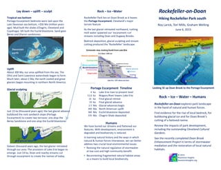
- 1. Lay down – uplift – sculpt Looking SE up Doan Brook to the Portage Escarpment Rockefeller-on-Doan explores park landscape in the hand of natural and human forces. Find evidence for the rise of local bedrock, for bulldozing glacial ice and for Doan Brook’s cutting of a beloved ravine. Review the impacts of park development, including the outstanding Cleveland Cultural Gardens. See the recently completed Doan Brook Enhancement Project in terms of stormwater mediation and the restoration of local natural habitats. Portage Escarpment bedrocks were laid upon the Late Devonian sea bottom, >350 Ma (million years ago). Mud built the shales (Chagrin, Cleveland and Cuyahoga). Silt built the Euclid bluestone. Sand gave Berea and Sharon sandstones. Rockefeller-on-DoanRock – Ice –Water Portage Escarpment Timeline Tropical sea bottom Glacial sculpting June 6, 2015 sandstone terrace bluestone terrace Glacial advance USGS LiDAR; Google Earth aerial viewer Hiking Rockefeller Park south © 2015 Bluestone Heights bluestoneheights.org Gesu School ka ka ka ka Ma Ma Ma Ma Lake Erie rises to present level Niagara River lowers Lake Erie Final glacial retreat Final glacial advance Glacial advances begin North American uplift Euclid bluestone deposited Chagrin Shale deposited • Reviving the natural regulation of stormwater at low cost and high community benefit. • Reconnecting fragmented natural habitat areas as a means to build local biodiversity. In learning natural history and the ways in which natural & human forces interweave, we can better address two crucial local environmental issues. Rockefeller Park lies on Doan Brook as it leaves the Portage Escarpment, Cleveland’s major terrain feature As the last glacier retreated northward, rushing melt water spawned our ‘escarpment run’ streams including Doan and Dugway Brooks. Bedrock deposition, glacial sculpting and stream cutting produced the ‘Rockefeller’ landscape. We have buried our streams and flattened our features. With development, environment is degraded and biodiversity is reduced. Humans Devonian earth LMichiganLMichigan L Huron L Huron About 300 Ma, our area uplifted from the sea. The Ohio and Saint Lawrence watersheds began to form. Much later, about 2 Ma, the earth cooled and great glaciers began mounting in northern North America. Lake Erie ~570’ above sea level Uplift we-are-stuff 4 12.6 16 23 2.5 300 360 370 pro-glacial lakes Roy Larick, Tori Mills, Graham Welling Rock – Ice – Water – Humans Blue Rock lake plain Just 23 ka (thousand years ago), the last glacial advance bulldozed the rock sandwich slope (Portage Escarpment) to create two terraces: one atop the Berea Sandstone and one atop the Euclid bluestone. Sixteen thousand years ago, the last glacier retreated through our area. The ancestors of Lake Erie began to emerge. Just 14 ka, Doan and nearby streams cut through escarpment to create the ravines of today.
- 2. © 2015 Bluestone Heights bluestoneheights.org glacial terrace – fossil beach – stream courses – springs Rockefeller Park, c. 1900 North K. Roberts K. Roberts USGS LiDAR underlay Google Earth aerial viewer Stream culvert data courtesy of NEORSD R. Larick Blue Rock spring, c. 1900 Rockefeller Park, 1897 R. Larick Rockefeller Park Spring, 1911 Rockefeller-on-Doan Cleveland Heights Cleveland Portage Escarpment, St Clair Terrace & lake plain Ambler spring, near Fairhill Rd Wade Park Spring. 1900 CMP CMP: Cleveland Memory Project ceveland.about.com Wade Oval, 1874 Rockefeller Park Rockefeller Park CMP CMP CMP CMP WRHS East Cleveland Early settlers valued clear (Wade, Rockefeller). Victorian water cure valued mineral (Ambler, Blue Rock). Eddy gristmill, 1809 Cozad gristmill, 1830s Crawford sawmill, 1830s Springs Mills E105th Wade Park Euclid D.J. Lake hike pathway