Capella Space Week 3 H4D Stanford 2016
•
1 j'aime•31,349 vues

agile, bmnt, business model, corporate innovation, customer development, diux, h4d, hacking for defense, lean, lean launchpad, lean startup, stanford, steve blank

Recommandé
Recommandé
Contenu connexe
Tendances
Tendances (20)
En vedette
En vedette (20)
Similaire à Capella Space Week 3 H4D Stanford 2016
Similaire à Capella Space Week 3 H4D Stanford 2016 (20)
Plus de Stanford University
Plus de Stanford University (20)
Dernier
Dernier (20)
Capella Space Week 3 H4D Stanford 2016
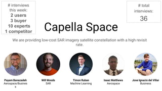
- 1. Capella Space We are providing low-cost SAR imagery satellite constellation with a high revisit rate. Payam Banazadeh Aerospace/Business Timon Ruban Machine Learning Isaac Matthews Aerospace Jose Ignacio del Villar Business Will Woods SAR # interviews this week: 2 users 3 buyer 10 experts 1 competitor # total interviews: 36 Redacted
- 2. Competitive Landscape (“Traditional Space”) Redacted Redacted Redacted
- 3. Competitive Landscape (“New Space”) Redacted Redacted Redacted
- 4. Capella (ROM) Price Capella first satellite price: 12 M (hardware, software, labor, development, launch) Capella n+1 satellite price: 5 M Capella 40 satellite constellation : < $200M Capella lead-time (if funded fully tomorrow): 12 months Capella initial milestone (next 5 months): $250k for demonstrating payload Redacted
- 5. Experiment #1 - dual-use case Hypothesis Experiment Result Action Government funding is not the proper channel for Capella Interviewed +5 experts and 1 competitor Confirmed. It’s easier to move from commercial to military than military to commercial. Finding strong supporters of the product is more important than getting funding from the government. We need to de-focus from finding “funding sources” within the government and focus on finding folks who can champion their needs to VCs for us
- 6. Experiment #2 - Coast guard is a big customer and needs high resolution imagery Hypothesis Experiment Result Action Coast guard is currently in dire need of situational awareness at high resolution Interviewed coast guard Size and inability to know what is going on in the sea is a major pain point. They currently use “flight tracker”-app to aid decisions. Big ships are not the main issues, the smaller vessels (40-50ft) are the main problem. Oil spill and SAR is what keeps them up at night Pursue this question more closely with coast guard to understand the exact needs. Specifically how often the small vessels need to be detected “The sea is vast” Redacted Redacted Redacted Redacted Redacted Redacted Redacted Redacted
- 7. Experiment #3 - Raw vs. Processed Data Hypothesis Experiment Result Action Military customer desires access to raw data; commercial customers highly value processed data for actionable insights. Interviewed coast guard and other stakeholders within the government and commercial sector Everyone is trying to get new data but very few are working on analyzing that data. Analyzing the data is extremely important when working directly with customers within DOD. Pursue this in more details with coast guard to understand what kind of analyzed data they need; determine data flow to decision maker Redacted Redacted Redacted Redacted Redacted Redacted Redacted Redacted
- 8. • Deploy 1 to 3 satellites and sell the images by September 2017. • Finish the deployment of 40 satellites by 2020. • Construction of payload for testing • Development of image analysis algorithms • Construction of satellite under required constraints • Data Analytics providers (Orbital Insight, Omni Earth, etc) • Sponsors (military and commercial) • Satellite structure providers • Satellite component providers • Orbital communication providers • Satellite launch providers • Get a customer in a country in the Equatorial orbit (Government) • Get commercial customers interested enough in our tech • The DHS and other government departments adopt our technology: • - USCG: to thwart drug trafficking from Ecuador and Colombia • Summer ground demonstration: $50k • First satellite: $6 million (including operations) • Subsequent satellites: $3 million each • Final constellation: $150 million total over 3 years • Funding to perform payload test during Summer 2016 • Government advocacy for our technology: DHS • Contacts in the Equatorial countries’ government agencies. Beneficiaries Mission AchievementMission Budget/Costs Buy-In/Support Deployment Value PropositionKey Activities Key Resources Commercial Satellite imagery resellers Illegal fishing in Indonesia Oil tankering in Nigeria Stop pirating at sea in Somalia Key Partners USCG Law Enforcement DO Information Watch Officer USCG - Stop more boats carrying drugs from Ecuador/Colombia - Reduce the cost of drug intervention operations NGA Provide better intelligence to other agencies/services Commercial Satellite Imagery Resellers: they can offer better and more diverse products Illegal fishing: tracking of ships that are doing suspicious activities at sea. Better law enforcement. NGA Intelligence Analysts Services in the DoD?? SOCOM Government sector driving demand (Indonesia, Nigeria, Ecuador, Colombia) Coast Guard Deputy Commandant for Operations (CG-DCO) Redacted Redacted Redacted Redacted Redacted Redacted Redacted Redacted Redacted
- 9. Products & Services Run counter-drug Operations Catch “bad guys on boats” Customer Jobs - “The sea is vast” -Low budget (=> cannot deploy to many resources) -Hard to know where to look/patrol Gains Pains Gain Creators Pain Relievers -Information on where boats are in patrol area lets duty officers deploy assets more strategically and more efficiently -High revisit rate enables duty officers to see smugglers even on quick runs (3-5h) - Stop more boats carrying drugs from Ecuador/Colombia - Reduce the cost of drug intervention operations Value Proposition Canvas - USCG Law Enforcement DO -provide locations of boats without AIS in desired area (extracted from SAR images) -web-based UI -modern machine learning/computer vision techniques can scan many images for boats and cover vast areas -locations of boats without AIS can queue where to send patrol vessels/aircrafts Redacted Redacted Redacted Redacted Redacted Redacted Redacted
- 10. Moving forward (week 3) Meeting at Skybox Meeting at Orbital Insight Meeting at NASA Ames Meeting (again) with coast guard Redacted
- 11. Products & Services Deliver geospatial intelligence to, warfighters, intelligence professionals and first responders Customer Jobs - Insufficient knowledge (images) of areas interesting for DoD services - Over-tasking of analysts - Backlog of un-extruded data Gains Pains Gain Creators Pain Relievers - Global Coverage - On-Demand SAR images made possible by a high revisit rate - Data conditioning alleviates analyst tasking - Extrusions may align with current tagging practices -Receive high-resolution imagery from arbitrary places on-demand to make it easy to deliver insight - ??? Value Proposition Canvas - NGA -radar satellites -high-resolution SAR and InSAR images Redacted Redacted Redacted Redacted Redacted Redacted Redacted
Notes de l'éditeur
- We have reached out to our assigned mentors, sponsors, and military liaisons and are leveraging the connections of this network to provide critical insights to open doors to contacts in the Navy 7th Fleet, and the military at large. Through our conversations, we have discovered that the US Navy and Coast Guard is interested in employing state of the art imaging platforms for wide area and continuous monitoring, specifically in the Arctic - SAR is a unique technology that affords the Navy and Coast Guard this capability. We have additionally discovered that the private sector, particularly companies in the Arctic region involved with the commerce, transportation, and exploitation of natural resources, may have an interest in the technology.