SlideShare une entreprise Scribd logo
1  sur  31
CYCLONES 
DEFINATION 
A cyclone is a low pressure area surrounded by high pressure 
area form all sides . It is a circular or elliptical in shape . 
Winds move from all sides to central low . They assume 
anticlockwise direction in the northern hemisphere and 
clockwise in the southern hemisphere due to cariolis effect. 
ITS OF TWO TYPES 
TEMPARERATE C YCLONE 
TROPICAL CYCLONE
CHARACTERSTICS OF CYCLONES 
To make the most efficient analysis of available data in the vicinity of typhoon, you must 
be familiar with the normal wind, pressure, temperature, clouds and weather pattern 
associated with these storms. 
1.SURFACE WINDS The surface winds blow inward in a counterclockwise 
direction toward the center. The winds in the left-rear quadrant have the 
greatest angle of inflow (in the Northern Hemisphere). The diameter of 
the area affected by hurricane or typhoon force winds may be in excess of 
100 miles in large storms or as small as 25 to 35 miles. Gale-force winds 
sometimes cover an area 500 to 800 miles or more. The maximum extent 
of strong winds is usually in the direction of the major subtropical high-pressure 
center, which is most frequently found to the right of the storm’s 
path in the Northern Hemisphere. Surface wind speeds of 140 knots have 
been successfully recorded, but accurate measurements of peak wind 
speeds in large mature storms have not been possible with any reliable 
degree of accuracy.
CHARACTERSTICS OF CYCLONES 
• SURFACE PRESSURE.— The sea-level isobars are 
an excellent tool with which to analyze these 
storms. The isobars take on a nearly symmetrical 
or elliptical shape, although deformations in the 
isobaric pattern are not uncommon. For instance, 
the tightest isobaric spacing (strongest pressure 
gradient) is found to the right of a storm’s line of 
movement, and a trough often extends 
southward from these storms. The central 
pressures of mature storms are well below 
average. Central pressures of 890 to 930 millibars 
are not uncommon.
CHARACTERSTICS OF CYCLONES 
• SURFACECE TEMPERATURE.— In contrast to extratropical cyclones, 
the tropical cyclone may show no cooling, or very little, toward the 
storm center. This indicates that the horizontal adiabatic cooling 
caused by lower pressures is largely offset by the heat added 
through the condensation process. Upper-air temperatures have 
been found warmer by 5 ‘C or more. 
• CLOUDS.— The cloud patterns of tropical cyclones also differ from 
those of extratropical cyclones. In mature tropical cyclones, almost 
all the cloud forms are present, but by and large the most 
significant clouds are the heavy cumulus and cumulonimbus which 
spiral inward toward the outer edge of the eye. These spiral bands, 
especially the leading ones, are also referred to as BARS. Cirrus and 
Cirrostratus occupy the largest portion of the sky over these storms. 
In fact, cirrus, becoming more dense, then changing to cirrostratus 
and lowering somewhat is more often than not a mariner’s first 
indication of an approaching distant storm or the development of 
one in the near vicinity. The appearance of the sky is very similar to 
that of an approaching warm front. A typical cloud distribution 
chart for a tropical cyclone is found in figure 9-3-7.
CHARACTERSTICS OF CYCLONES 
THE EYE.— The eye of a storm is one of the oddest 
phenomena known in meteorology. Precipitation 
ceases abruptly at the boundary of a well-developed 
eye; the sky partly clears; the sun or stars become 
visible; the wind subsides to less than 15 knots, and at 
times there is a dead calm. In mature storms, the eye’s 
diameter averages about 15 miles, but it may attain 40 
miles in large typhoons. The eye is not always circular; 
sometimes it becomes elongated and even diffuse 
with a double structure appearance. The eye is 
constantly undergoing transformation and does not 
stay in a steady state.
INTENSITY CLASSIFICATION 
• A tropical depression is the lowest category that the Japan Meteorological Agency 
uses and is the term used for a tropical system that has wind speeds not exceeding 
33 knots (38 mph; 61 km/h).[7] A tropical depression is upgraded to a tropical 
storm should its sustained wind speeds exceed 34 knots (39 mph; 63 km/h). 
Tropical storms also receive official names from RSMC Tokyo.[7] Should the storm 
intensify further and reach sustained wind speeds of 48 knots (55 mph; 89 km/h) 
then it will be classified as a severe tropical storm.[7] Once the system's maximum 
sustained winds reach wind speeds of 64 knots (74 mph; 119 km/h), the JMA will 
designate the tropical cyclone as a typhoon—the highest category on its scale.[7] 
• From 2009 the Hong Kong Observatory started to further divide typhoons into 
three different classifications: typhoon, severe typhoon and super typhoon.[8] A 
typhoon has wind speed of 64-79 knots (73-91 mph; 118-149 km/h), a severe 
typhoon has winds of at least 80 knots (92 mph; 150 km/h), and a super typhoon 
has winds of at least 100 knots (120 mph; 190 km/h).[8] The United States' Joint 
Typhoon Warning Center (JTWC) unofficially classifies typhoons with wind speeds 
of at least 130 knots (67 m/s; 150 mph; 241 km/h)—the equivalent of a strong 
Category 4 storm in the Saffir-Simpson scale—as super typhoons.[9] However, the 
maximum sustained wind speed measurements that the JTWC uses are based on a 
1-minute averaging period, akin to the U.S.' National Hurricane Center and Central 
Pacific Hurricane Center. As a result, the JTWC's wind reports are higher than 
JMA's measurements, as the latter are based on a 10-minute averaging 
interval.[10]
INTENSITY CLASSIFICATION 
CATEGORY SUBSTAINED WINDS 
TYPHOON 64 – 84 KNOTS 
118 - 156 KM/H 
SEVERE TROPICAL 
STORM 
48 - 63 KNOTS 
89 - 117 KM/H 
TROPICAL STORM 34 -47 KNOTS 
62 - 88 KM/H 
TROPICAL 
DISPERSION 
< 33 KNOTS 
< 61 KM/H
FORMATION OF CYCLONES 
• In tropical oceans, the water in the oceans' surface layer heated by the direct solar 
radiation. As a result, the air above the tropical oceans is characterized by high 
temperature and humidity, resulting in air inflation that easily leads to low density per 
unit volume of air. Weak wind near the equator causes the lighter air to soar and incur 
convection that further attracts inflow of surrounding cooler air. The intake air then 
warms up and soars again, creating a positive feedback cycle that eventually forms an air 
column with high temperature, light weight and low density. This is how the tropical 
depression forms. 
• The air flows from high pressure towards low pressure as if the water flows from high to 
low elevation. The surrounding air with higher pressure will flow towards where the 
pressure is lower, creating the "wind." As the area for direct solar radiation moves 
northward away from the equator in summer, the southeasterly trade wind in the 
Southern Hemisphere crosses the equator and penetrates into the Northern Hemisphere 
in the form of southwest monsoon, which has heads-on encounter with the 
northeasterly trade wind in the Northern Hemisphere and forces the air in this area to 
soar, creating more convection. Furthermore, the wind convergence resulting from the 
southwesterly and the northeasterly trade winds often cause air turbulence and 
whirlpool. These convergence effects, when continually enhanced by the convection 
activity, further deepens the existing low-pressure vortex, resulting in more and faster 
ambient air flow been drawing into the vortex center. Faster inflow corresponds to higher 
wind speed which, when the near-ground maximum speed reaches or exceeds 62 km per 
hour or 17.2 meter per second, is characteristic of a typhoon.
FORMATION OF CYCLONES
NAMING OF CYCLONES 
• Tropical cyclones have officially been named since 1945 and are named for 
a variety of reasons, which include to facilitate communications between 
forecasters and the public when forecasts, watches, and warnings are 
issued. Names also reduce confusion about what storm is being described, 
as more than one can occur in the same region at the same time.[1] The 
official practice of naming tropical cyclones started in 1945 within the 
Western Pacific and was gradually extended out until 2004, when the 
Indian Meteorological Department started to name cyclonic storms within 
the North Indian ocean. Names were first given to storms by Australian 
meteorologist Clement Wragge from 1887, Before the official practice of 
naming of tropical cyclones began, significant tropical cyclones were 
named after annoying politicians, mythological creatures, saints and place 
names. Names are drawn in order from predetermined lists (see Lists of 
tropical cyclone names) and are usually assigned to tropical cyclones with 
one-, three-, or ten-minute sustained wind speeds of more than 65 km/h 
(40 mph) depending on which area it originates. However, standards vary 
from basin to basin with some tropical depressions named in the Western 
Pacific, while within the Southern Hemisphere tropical cyclones have to 
have a significant amount of gale-force winds occurring around the center 
before they are named.
EFFECTS OF CYCLONES 
• The main effects of tropical cyclones include heavy rain, strong 
wind, large storm surges at landfall, and tornadoes. The destruction 
from a tropical cyclone depends mainly on its intensity, its size, and 
its location. Tropical cyclones act to remove forest canopy as well as 
change the landscape near coastal areas, by moving and reshaping 
sand dunes and causing extensive erosion along the coast. Even 
well inland, heavy rainfall can lead to mudslides and landslides in 
mountainous areas. Their effects can be sensed over time by 
studying the concentration of the Oxygen-18 isotope within caves 
within the vicinity of cyclones' paths. 
• After the cyclone has passed, devastation often continues. Standing 
water can cause the spread of disease, and transportation or 
communications infrastructure may have been destroyed, 
hampering clean-up and rescue efforts. Nearly two million people 
have died globally due to tropical cyclones. Despite their 
devastating effects, tropical cyclones are also beneficial, by 
potentially bringing rain to dry areas and moving heat from the 
tropics poleward. Out at sea, ships take advantage of their known 
characteristics by navigating through their weaker, western half.
EFFECTS OF CYCLONES 
AT SEA 
• A mature tropical cyclone can release heat at a rate upwards of 
6x10¹⁴ watts.[1] Tropical cyclones on the open sea cause large 
waves, heavy rain, and high winds, disrupting international shipping 
and, at times, causing shipwrecks.[2] Generally, after its passage, a 
tropical cyclone stirs up ocean water, lowering sea surface 
temperatures behind it.[3] This cool wake can cause the region to 
be less favorable for a subsequent tropical cyclone. On rare 
occasions, tropical cyclones may actually do the opposite. 2005's 
Hurricane Dennis blew warm water behind it, contributing to the 
unprecedented intensity of Hurricane Emily, which followed it 
closely.[4] Hurricanes help to maintain the global heat balance by 
moving warm, moist tropical air to the mid-latitudes and polar 
regions.[5] Were it not for the movement of heat poleward 
(through other means as well as hurricanes), the tropical regions 
would be unbearably hot.
EFFECTS OF CYCLONES 
STORM SURGE 
• The aftermath of Hurricane Katrina in Gulfport, Mississippi. 
Katrina was the costliest tropical cyclone in United States 
history. 
• See also: Storm surge 
• The storm surge, or the increase in sea level due to the 
cyclone, is typically the worst effect from landfalling 
tropical cyclones, historically resulting in 90% of tropical 
cyclone deaths.[13] The relatively quick surge in sea level 
can move miles/kilometers inland, flooding homes and 
cutting off escape routes. The storm surges and winds of 
hurricanes may be destructive to human-made structures, 
but they also stir up the waters of coastal estuaries, which 
are typically important fish breeding locales.
EFFECTS OF CYCLONES 
HEAVY RAINFALL 
• The thunderstorm activity in a tropical cyclone produces intense rainfall, 
potentially resulting in flooding, mudslides, and landslides. Inland areas are 
particularly vulnerable to freshwater flooding, due to residents not preparing 
adequately.[14] Heavy inland rainfall eventually flows into coastal estuaries, 
damaging marine life in coastal estuaries.[15] The wet environment in the 
aftermath of a tropical cyclone, combined with the destruction of sanitation 
facilities and a warm tropical climate, can induce epidemics of disease which claim 
lives long after the storm passes.[13] Infections of cuts and bruises can be greatly 
amplified by wading in sewage-polluted water. Large areas of standing water 
caused by flooding also contribute to mosquito-borne illnesses. Furthermore, 
crowded evacuees in shelters increase the risk of disease propagation.[13] 
• Flooding in Seminole County, Florida from Tropical Storm Fay (2008) 
• Although cyclones take an enormous toll in lives and personal property, they may 
be important factors in the precipitation regimes of places they affect and bring 
much-needed precipitation to otherwise dry regions. Hurricanes in the eastern 
north Pacific often supply moisture to the Southwestern United States and parts of 
Mexico.[16] Japan receives over half of its rainfall from typhoons.[17] Hurricane 
Camille averted drought conditions and ended water deficits along much of its 
path,[18] though it also killed 259 people and caused $9.14 billion (2005 USD) in 
damage.
EFFECTS OF CYCLONES 
DEATHS 
• During the last two centuries, tropical 
cyclones have been responsible for the deaths 
of about 1.9 million people worldwide. It is 
estimated that 10,000 people per year perish 
due to tropical cyclones.[21] The deadliest 
tropical cyclone was the 1970 Bhola cyclone, 
which had a death toll of anywhere from 
300,000 to 500,000 lives.
EFFECTS OF CYCLONES 
RECONSTURCTION AND REPOUPLATION 
• Aerial image of destroyed homes in Punta Gorda, Florida, following 
Hurricane Charley 
• While tropical cyclones may well seriously damage settlement, total 
destruction encourages rebuilding. For example, the destruction 
wrought by Hurricane Camille on the Gulf coast spurred 
redevelopment, greatly increasing local property values.[18] 
Research indicates that the typical hurricane strike raises real house 
prices for a number of years, with a maximum effect of between 3 
percent to 4 percent three years after occurrence.[25] However, 
disaster response officials point out that redevelopment 
encourages more people to live in clearly dangerous areas subject 
to future deadly storms. Hurricane Katrina is the most obvious 
example, as it devastated the region that had been revitalized after 
Hurricane Camille. Many former residents and businesses do 
relocate to inland areas away from the threat of future hurricanes 
as well.
EFFECTS OF CYCLONES
EFFECTS OF CYCLONES
TRACKS AND AREAS OF CYCLONES 
• Tropical cyclones are more active in summer . Their 
areas of activity is the tropical zone. 
• The following are some of the characteristics of the 
tracks of a cyclones : 
• 1. Between the equator and 15°latitude, these storms 
turn towards the west with the trades. 
• 2. Between 15° and 30° latitude the path is very 
uncertain. But these travel towards the north in the 
northern hemisphere and the south in the southern 
hemisphere. 
• 3. As these cross 30° latitude they turn towards the 
east and take much of the character of the temperate 
cyclone . Their terrific energy also declines.
DIFFERENT NAMES OF CYCLONES IN 
DIFFERENT COUNTRIES 
• The chief areas of activity for the cyclone are the following : 
• 1. West Indies and the Coast of Florida. In that region these 
are known as HURRICANES. 
• 2. Philippine Islands, the coasts of China and Japan. These 
are known as TYPHOONS. 
• 3. Bay of Bengal and the Arabian Sea, where these are 
known as CYCLONES. 
• 4. Madagascar and the coastal regions of East Africa. 
• 5. Northeast and Northwestern coasts of Australia, where 
they are called WELLY-WELLIES. 
• They are known as TORNADOES in the U.S.A. and Mexico.
HISTORIC LIST 
• Tropical cyclones are named for historical reasons and so to avoid confusion when 
communicating with the public as more than one tropical cyclone can exist at a 
time. Names are drawn in order from predetermined lists and are usually assigned 
to tropical cyclones with one, three or ten minute wind speeds of more than 65 
km/h (40 mph). However standards vary from basin to basin with some tropical 
depressions named in the Western Pacific whilst tropical cyclones have to have 
gale force winds occurring more than halfway around the center within the 
Australian and Southern Pacific regions. 
• The official practice of naming tropical cyclones started in 1945 within the Western 
Pacific. Naming continued through the next few years before in 1950, names also 
started to be assigned to tropical storms forming in the North Atlantic ocean. In 
the Atlantic, names were originally taken from the world war two version of the 
Phonetic Alphabet but this was changed in 1953 to use lists of women names 
which were drawn up yearly. Around this time naming of tropical cyclones also 
began within the Southern and Central parts of the Pacific. However naming didn't 
begin the Eastern Pacific until 1960 with the original naming lists designed to be 
used year after year in sequence. In 1960, naming also began in the Southwest 
Indian Ocean before in 1963 the Philippine Meteorological Service, started 
assigning names to tropical cyclones that moved into or formed in their area of 
responsibility. Later in 1963 warning centers within the Australian region also 
commenced naming tropical cyclones.
HISTORIC LIST 
• NORTH ATLANTIC 
• By 1950 tropical cyclones that were judged by the US Weather Bureau to have intensified into a 
tropical storm, started to be assigned names.[1][2] Storms were originally named in alphabetical 
order using the World War II version of the Phonetic Alphabet.[1] By 1952 a new phonetic alphabet 
had been developed and this led to confusion as some parties wanted to use the newer phonetic 
alphabet.[1] In 1953, to alleviate any confusion, forecasters decided to use a set of 23 feminine 
names.[1][2] After the 1953 Atlantic hurricane season, public reception to the idea seemed 
favorable, so the same list was adopted for the next year with one change; Gilda for Gail.[1] 
However after storms like Carol and Hazel got a lot of publicity during the 1953 season, forecasters 
agreed to develop a new set of names for 1955.[1] However before this could happen, a tropical 
storm was declared significant on January 2, 1955 and was named as Alice.[1] The new set of 
names were developed and used in 1955 beginning with Brenda continuing through the alphabet 
to Zelda.[1] For each season before 1960, a new set of names were developed.[1] In 1960 
forecasters decided to begin rotating names in a regular sequence and thus four alphabetical lists 
were established to be repeated every four years.[3] The sets followed the example of the western 
Pacific typhoon naming lists and excluded names beginning with the letters Q, U, X, Y and Z.[3] 
These four lists were used until 1972 when the National Oceanic and Atmospheric Administration 
(NOAA), replaced them with 9 lists designed to be used from 1972.[3] In 1977, NOAA made the 
decision to relinquish control over the name selection by allowing a regional committee of the 
World Meteorological Organization to select the new sets of names which would contain male 
names and some Spanish and French names in order to reflect all the cultures and languages within 
the Atlantic Ocean.[2][3] The World Meteorological Organization decided that the new lists of 
hurricane name would start to be used in 1979.[2][3] Since 1979 the same lists have been used, 
with names of significant tropical cyclones removed from the lists and replaced with new names.[2] 
In 2002 Subtropical Cyclones started to be assigned names from the main list of names set up for 
that year. In 2005 as all the names preselected for the season were exhausted, the contingency plan 
of using Greek letters for names had to be used.[4] Since then there have been a few attempts to 
get rid of the Greek names, as they are seen to be inconsistent with the standard naming 
convention used for tropical cyclones and are considered generally unknown and confusing to the 
public.[5] However the lists of preselected names for the year, are not expected to be used up 
frequently enough to warrant any change in the existing naming procedure and thus the Greek 
Alphabet will be used if the list of pre selected names should ever be used up again.[5][6][7]
HISTORIC LIST 
• EASTERN PACIFIC 
• Within the Eastern Pacific basin between the western coasts of the Americas and 140°W the 
naming of tropical cyclones started in 1960, with four lists of female names initially designed to be 
used consecutively before being repeated.[31][32] In 1965 after two lists of names had been used, 
it was decided to return to the top of the second list and to start recycling the sets of names on an 
annual basis.[32][33] 
• In 1977, after protests by various women's rights groups, NOAA made the decision to relinquish 
control over the name selection by allowing a regional committee of the World Meteorological 
Organization (WMO) to select new sets of names.[3] The WMO selected six lists of names which 
contained male names and rotated every six years.[3] They also decided that the new lists of 
hurricane name would start to be used in 1978 which was a year earlier than the Atlantic.[34] Since 
1978 the same lists of names have been used, with names of significant tropical cyclones removed 
from the lists and replaced with new names.[32] As in the Atlantic basin should the names 
preselected for the season be exhausted, the contingency plan of using Greek letters for names 
would be used.[32][35] However unlike in the Atlantic basin the contingency plan has never had to 
be used, although in 1985 to avoid using the contingency plan, the letters X, Y, and Z were added to 
the lists.[35] Since the contingency plan had to be used in the North Atlantic during 2005 there 
have been a few attempts to get rid of the Greek names as they are seen to be inconsistent with 
the standard naming convention used for tropical cyclones and are generally unknown and 
confusing to the public.[5][6] However none of the attempts have succeeded and thus the Greek 
letters will be used should the lists be used up.[5][6]
HISTORIC LIST 
WESTERN NORTH PACIFIC 
• In the Western North Pacific ocean, there are two sets of names 
generally used. The first are the international names assigned to a 
tropical cyclone by the Japan Meteorological Agency (JMA) or the 
Joint Typhoon Warning Center (JTWC). The second set of names are 
local names assigned to a tropical cyclone by the Philippine 
Atmospheric, Geophysical and Astronomical Services 
Administration. This system often ends up with a tropical cyclone 
being assigned two names, should a tropical storm threaten the 
Philippines. 
• On January 1, 2000 the Japan Meteorological Agency as the official 
Regional Specialized Meteorological Center took over the naming of 
Tropical storms. The names selected by the World Meteorological 
Organization's Typhoon Committee were from a pool of names 
submitted by the various countries that make up the Typhoon 
Committee.
HISTORIC LIST 
• CENTRAL NORTH PACIFIC 
• In 1950 a tropical cyclone that affected Hawaii was named Able, after a tropical 
cyclone had not affected Hawaii for a number of years.[40][41] The system 
subsequently became widely known as Hurricane Hiki, since Hiki is Hawaiian for 
Able.[40][41] Typhoons Olive and Della of 1952 and 1957 developed within the 
Central Pacific, but were not named until they had crossed the International 
Dateline and moved into the Western Pacific basin.[40][42] During 1957, two other 
tropical cyclones developed in the Central Pacific and were named Kanoa and 
Nina, by the Hawaiian military meteorological offices.[42] It was subsequently 
decided that future tropical cyclones, would be named by borrowing names from 
the Western Pacific naming lists.[42] During 1979, after ten names had been 
borrowed from the Western Pacific naming lists, Hawaiian names were reinstated 
for tropical cyclones developing into tropical storms forming in the Central 
Pacific.[33] Five sets of Hawaiian names, using only the 12 letters of the Hawaiian 
alphabet, were drafted with the intent being to use the sets of names on an 
annual rotation basis.[33] However, after no storms had developed in this region 
between 1979 and 1981, the annual lists were scrapped and replaced with four 
sets of names and designed to be used consecutively.[33] Ahead of the 2007 
hurricane season, the Central Pacific Hurricane Center (CPHC) introduced a revised 
set of Hawaiian names for the Central Pacific, after they had worked with the 
University of Hawaii Hawaiian Studies Department to ensure the correct meaning 
and appropriate historical and cultural use of the names.[43]
HISTORIC LIST 
• PHILIPPINES 
• Since 1963, the Philippine Atmospheric, Geophysical and 
Astronomical Services Administration (PAGASA), have assigned their 
own names to typhoons that pass through its area of 
responsibility.[45] Unlike the World Meteorological Organization's 
standard of assigning names to tropical cyclones when they reach 
wind-speeds of 65 km/h, (40 mph), PAGASA assigns a name to a 
tropical depression when they either form or move into their area 
of responsibility.[45][46] Four sets of tropical cyclone names are 
rotated annually with typhoon names stricken from the list should 
they do more than 1 billion Pesos worth of damage to the 
Philippines and/or cause 300 or more deaths.[47][48] Should the 
list of names for a given year prove insufficient, names are taken 
from an auxiliary list.[47]
HISTORIC LIST 
• NORTH INDIAN OCEAN 
• During its annual session in 2000 the WMO/ESCAP Panel on North Indian tropical cyclones, agreed 
in principle to start assigning names to Cyclonic Storms that developed within the North Indian 
Ocean.[61][62] As a result the panel requested that each member country submit a list of ten 
names to a rapporteur by the end of the year 2000.[62] At the 2001 session of the Panel, the 
rapporteur reported that seven of the eight countries had submitted their names.[62] However, 
India had refused to submit a list of names, as it had some reservations about assigning names to 
tropical cyclones, due to the regional, cultural and lingustic diverstiy of the panel members.[62] The 
panel subsquently studied the names and felt that some of the names would not be appealing to 
the public or the media, and requested that members submit new lists of names.[62] At the 
following years session the rapporteur reported that there had been a poor response by member 
countries in resubmitting their lists of names.[62] In response the panel felt that it was important 
that the work continued and urged the members to copperate and submit their names to the 
rapporteur.[62] The names were subsquently submitted in time for the 2004 session, however, 
India had still not submitted their names, despite promising to do so.[62] The rapporteur presented 
the 4 lists of names that would be used with a gap left for India's names and recommended that 
the India Meteorological Department's Regional Specialised Meterological Centre in New Delhi 
name the systems.[62] The rapporteur also recommended that the naming lists were used on an 
experimental basis during the season, starting in May or June 2004 and that the lists should only be 
used until 2009 when a new list would be drawn up for the following ten years.[62] The naming lists 
were then completed in May 2004, after India submitted their names, however the lists were not 
used until September 2004 when the first tropical cyclone was named Onil by India Meteorological 
Department.[61][63]
PLANS FOR DETECTION 
• Because of the forces that affect tropical cyclone tracks, accurate track predictions 
depend on determining the position and strength of high- and low-pressure areas, 
and predicting how those areas will change during the life of a tropical system. The 
deep layer mean flow, or average wind through the depth of the troposphere, is 
considered the best tool in determining track direction and speed. If storms are 
significantly sheared, use of wind speed measurements at a lower altitude, such as 
at the 70 kPa pressure surface (3,000 metres or 9,800 feet above sea level) will 
produce better predictions. Tropical forecasters also consider smoothing out short-term 
wobbles of the storm as it allows them to determine a more accurate long-term 
trajectory.[107] High-speed computers and sophisticated simulation software 
allow forecasters to produce computer models that predict tropical cyclone tracks 
based on the future position and strength of high- and low-pressure systems. 
Combining forecast models with increased understanding of the forces that act on 
tropical cyclones, as well as with a wealth of data from Earth-orbiting satellites and 
other sensors, scientists have increased the accuracy of track forecasts over recent 
decades.[108] However, scientists are not as skillful at predicting the intensity of 
tropical cyclones.[109] The lack of improvement in intensity forecasting is 
attributed to the complexity of tropical systems and an incomplete understanding 
of factors that affect their development.
MANAGEMENT OF CYCLONES 
• Cyclone, tropical cyclone, hurricane, and typhoon 
are different names for the same phenomenon a 
cyclonic storm system that forms over the 
oceans. The deadliest hurricane ever was the 
1970 Bhola cyclone; the deadliest Atlantic 
hurricane was the Great Hurricane of 1780 which 
devastated Martinique, St. Eustatius and 
Barbados. Another notable hurricane is Hurricane 
Katrina which devastated the Gulf Coast of the 
United States in 2005.
MANAGEMENT OF CYCLONES 
• An effective disaster management system consists of four main 
components — disaster prediction, disaster warning, disaster 
management and disaster relief. Disaster warning is a basic prerequisite 
for ensuring disaster preparedness and in some cases to help in the 
prevention of disaster itself. Clearly the most important application of 
satellites is in detecting, predicting and delivering early warning of 
impending disasters such as flood, drought, cyclone and even forest fires 
(Rao et al. 1987; Heath 1994). Continuous monitoring by both 
geostationary and low earth orbiting weather satellites like GOES, INSAT, 
METEOSAT and NOAA is capable of providing early warning on cyclones 
and floods. Forest fires, environmental hazards, volcanic eruptions and 
even propagation of desert locust phenomena can be detected well in 
time by remote sensing satellites like, LANDSAT, SPOT and IRS. Sustainable 
development strategy must address this important issue in order to 
provide stability and reasonable security to the vulnerable rural 
population in these countries. Remote sensing information are now 
operationally used to regularly monitor flood conditions, volume of water 
flow and damage assessment. From such a database collected over years, 
it is possible to identify different risk zones in the flood prone area based 
on the severity index for flood proneness of each zone. Optimal treatment 
of each zone on a long term basis, depending on the severity, can then be 
attempted to achieve reduction in flood damage without impairing 
environmental integrity (Rao 1993)
Cyclones

Contenu connexe

Tendances

Tropical cyclone
Tropical cycloneTropical cyclone
Tropical cycloneMercy Simon
 
Tornado Presentation , Formation of tornado , Causes , Types , Mitigation of ...
Tornado Presentation , Formation of tornado , Causes , Types , Mitigation of ...Tornado Presentation , Formation of tornado , Causes , Types , Mitigation of ...
Tornado Presentation , Formation of tornado , Causes , Types , Mitigation of ...Chandan Pradhan
 
Atmospheric circulation-Climatology Chapter
Atmospheric circulation-Climatology ChapterAtmospheric circulation-Climatology Chapter
Atmospheric circulation-Climatology ChapterKaium Chowdhury
 
Cyclones and anticyclones
Cyclones and anticyclonesCyclones and anticyclones
Cyclones and anticyclonesNaveenpadukone
 
Atmospheric stability
Atmospheric stabilityAtmospheric stability
Atmospheric stabilityYasir Hashmi
 
Meteorological hazards.pptx
Meteorological hazards.pptxMeteorological hazards.pptx
Meteorological hazards.pptxssuseraf2145
 
Indian Ocean Dipole (IOD)
Indian Ocean Dipole (IOD)Indian Ocean Dipole (IOD)
Indian Ocean Dipole (IOD)HarshitaPant6
 
What is Fog and Mechanism
What is Fog and MechanismWhat is Fog and Mechanism
What is Fog and Mechanismmnikzaad
 
Temperature and it’s distribution(ocean)
Temperature and it’s distribution(ocean)Temperature and it’s distribution(ocean)
Temperature and it’s distribution(ocean)Tanuj Joshi
 
Cyclones and western disturbances By Lohit Saini
Cyclones and western disturbances By Lohit SainiCyclones and western disturbances By Lohit Saini
Cyclones and western disturbances By Lohit Sainilohitsaini
 

Tendances (20)

Tropical cyclone
Tropical cycloneTropical cyclone
Tropical cyclone
 
Tornado Presentation , Formation of tornado , Causes , Types , Mitigation of ...
Tornado Presentation , Formation of tornado , Causes , Types , Mitigation of ...Tornado Presentation , Formation of tornado , Causes , Types , Mitigation of ...
Tornado Presentation , Formation of tornado , Causes , Types , Mitigation of ...
 
Atmospheric circulation-Climatology Chapter
Atmospheric circulation-Climatology ChapterAtmospheric circulation-Climatology Chapter
Atmospheric circulation-Climatology Chapter
 
Cyclones and anticyclones
Cyclones and anticyclonesCyclones and anticyclones
Cyclones and anticyclones
 
Tsunami
Tsunami Tsunami
Tsunami
 
CYCLONE
CYCLONECYCLONE
CYCLONE
 
Cylones ppt
Cylones pptCylones ppt
Cylones ppt
 
Meteorology
MeteorologyMeteorology
Meteorology
 
Atmospheric stability
Atmospheric stabilityAtmospheric stability
Atmospheric stability
 
Meteorological hazards.pptx
Meteorological hazards.pptxMeteorological hazards.pptx
Meteorological hazards.pptx
 
Thunderstorms
ThunderstormsThunderstorms
Thunderstorms
 
Indian Ocean Dipole (IOD)
Indian Ocean Dipole (IOD)Indian Ocean Dipole (IOD)
Indian Ocean Dipole (IOD)
 
What is Fog and Mechanism
What is Fog and MechanismWhat is Fog and Mechanism
What is Fog and Mechanism
 
Storm Surges
Storm SurgesStorm Surges
Storm Surges
 
Cyclone
CycloneCyclone
Cyclone
 
Temperature and it’s distribution(ocean)
Temperature and it’s distribution(ocean)Temperature and it’s distribution(ocean)
Temperature and it’s distribution(ocean)
 
Cyclones and western disturbances By Lohit Saini
Cyclones and western disturbances By Lohit SainiCyclones and western disturbances By Lohit Saini
Cyclones and western disturbances By Lohit Saini
 
Jet streams
Jet streamsJet streams
Jet streams
 
Energy budget of earth
Energy budget of earthEnergy budget of earth
Energy budget of earth
 
Air masses and fronts
Air masses and frontsAir masses and fronts
Air masses and fronts
 

En vedette

Cyclone power point
Cyclone power pointCyclone power point
Cyclone power pointStacey
 
The Physical Characteristics of Tropical Cyclones
The Physical Characteristics of Tropical CyclonesThe Physical Characteristics of Tropical Cyclones
The Physical Characteristics of Tropical Cyclonesbreannej35
 
How Cyclones Are Formed
How Cyclones Are FormedHow Cyclones Are Formed
How Cyclones Are Formedallstars
 
Tropical Cyclones (Science V )
Tropical Cyclones (Science V )Tropical Cyclones (Science V )
Tropical Cyclones (Science V )Ofhel Del Mundo
 
Cyclone and its types
Cyclone and its typesCyclone and its types
Cyclone and its typesMicrobiology
 
Cyclones
CyclonesCyclones
CyclonesTrev
 
Cyclone Nikhil & Mazar
Cyclone Nikhil & MazarCyclone Nikhil & Mazar
Cyclone Nikhil & Mazarsubzero64
 
2 Introduction To Tropical Cyclones
2 Introduction To Tropical Cyclones2 Introduction To Tropical Cyclones
2 Introduction To Tropical CyclonesEcumene
 
Natural Disasters Topic 10 (Cyclones)
Natural Disasters Topic 10 (Cyclones)Natural Disasters Topic 10 (Cyclones)
Natural Disasters Topic 10 (Cyclones)William W. Little
 
3 Bangladesh Case Study Intro
3 Bangladesh Case Study Intro3 Bangladesh Case Study Intro
3 Bangladesh Case Study IntroEcumene
 
Action Plan for Cyclone Disaster Management
Action Plan for Cyclone Disaster Management Action Plan for Cyclone Disaster Management
Action Plan for Cyclone Disaster Management Jahangirnagar University
 

En vedette (20)

Cyclones!!!!
Cyclones!!!!Cyclones!!!!
Cyclones!!!!
 
Cyclone power point
Cyclone power pointCyclone power point
Cyclone power point
 
Cyclone
CycloneCyclone
Cyclone
 
The Physical Characteristics of Tropical Cyclones
The Physical Characteristics of Tropical CyclonesThe Physical Characteristics of Tropical Cyclones
The Physical Characteristics of Tropical Cyclones
 
Cyclone
CycloneCyclone
Cyclone
 
How Cyclones Are Formed
How Cyclones Are FormedHow Cyclones Are Formed
How Cyclones Are Formed
 
Cyclones
CyclonesCyclones
Cyclones
 
Tropical Cyclones (Science V )
Tropical Cyclones (Science V )Tropical Cyclones (Science V )
Tropical Cyclones (Science V )
 
Cyclone and its types
Cyclone and its typesCyclone and its types
Cyclone and its types
 
Cyclones
CyclonesCyclones
Cyclones
 
Cyclone Nikhil & Mazar
Cyclone Nikhil & MazarCyclone Nikhil & Mazar
Cyclone Nikhil & Mazar
 
2 Introduction To Tropical Cyclones
2 Introduction To Tropical Cyclones2 Introduction To Tropical Cyclones
2 Introduction To Tropical Cyclones
 
Natural Disasters Topic 10 (Cyclones)
Natural Disasters Topic 10 (Cyclones)Natural Disasters Topic 10 (Cyclones)
Natural Disasters Topic 10 (Cyclones)
 
3 Bangladesh Case Study Intro
3 Bangladesh Case Study Intro3 Bangladesh Case Study Intro
3 Bangladesh Case Study Intro
 
Action Plan for Cyclone Disaster Management
Action Plan for Cyclone Disaster Management Action Plan for Cyclone Disaster Management
Action Plan for Cyclone Disaster Management
 
Cyclone
CycloneCyclone
Cyclone
 
floods
floodsfloods
floods
 
Earthquakes
EarthquakesEarthquakes
Earthquakes
 
Floods
FloodsFloods
Floods
 
Earthquake ppt
Earthquake pptEarthquake ppt
Earthquake ppt
 

Similaire à Cyclones

Climate: Hurricane Basic Detail
Climate: Hurricane Basic DetailClimate: Hurricane Basic Detail
Climate: Hurricane Basic Detailgeomillie
 
Natural Science: Weather and Storms
Natural Science: Weather and StormsNatural Science: Weather and Storms
Natural Science: Weather and StormsShamie Garcia
 
cyclone.pptx............................
cyclone.pptx............................cyclone.pptx............................
cyclone.pptx............................pauloalegria3
 
Cyclones Tropical and Mid-latitude .pptx
Cyclones Tropical and Mid-latitude .pptxCyclones Tropical and Mid-latitude .pptx
Cyclones Tropical and Mid-latitude .pptxBRYAN SHINGANGE
 
Typhoon Final Presentation.pptx
Typhoon Final Presentation.pptxTyphoon Final Presentation.pptx
Typhoon Final Presentation.pptxOrleanTroyAgad
 
CYCLONE NEW PPT TODAY.pptx
CYCLONE NEW PPT TODAY.pptxCYCLONE NEW PPT TODAY.pptx
CYCLONE NEW PPT TODAY.pptxBaDriGaMeR
 
Atmospheric Disturbances, Storms and Natural Hazards.pptx
Atmospheric Disturbances, Storms and Natural Hazards.pptxAtmospheric Disturbances, Storms and Natural Hazards.pptx
Atmospheric Disturbances, Storms and Natural Hazards.pptxRalphNavelino3
 
Tropical cyclones and temperate cyclones
Tropical cyclones and temperate cyclonesTropical cyclones and temperate cyclones
Tropical cyclones and temperate cyclonesgeovino
 
TROPICAL RVOLVING STORM.ppt
TROPICAL RVOLVING STORM.pptTROPICAL RVOLVING STORM.ppt
TROPICAL RVOLVING STORM.pptMoises Tenyosa
 
cyclone hazards pdf
cyclone hazards pdfcyclone hazards pdf
cyclone hazards pdfRishu Mishra
 
Hydrometeorological Hazards.pptx
Hydrometeorological Hazards.pptxHydrometeorological Hazards.pptx
Hydrometeorological Hazards.pptxRoxanneMaeDagotdot
 

Similaire à Cyclones (20)

Typhoon
TyphoonTyphoon
Typhoon
 
Climate: Hurricane Basic Detail
Climate: Hurricane Basic DetailClimate: Hurricane Basic Detail
Climate: Hurricane Basic Detail
 
Exogenous disasters cyclones
Exogenous disasters    cyclonesExogenous disasters    cyclones
Exogenous disasters cyclones
 
Cyclones as natural hazards
Cyclones as natural hazardsCyclones as natural hazards
Cyclones as natural hazards
 
Natural Science: Weather and Storms
Natural Science: Weather and StormsNatural Science: Weather and Storms
Natural Science: Weather and Storms
 
cyclone.pptx............................
cyclone.pptx............................cyclone.pptx............................
cyclone.pptx............................
 
Understanding Typhoon g8
Understanding Typhoon g8Understanding Typhoon g8
Understanding Typhoon g8
 
Cyclones Tropical and Mid-latitude .pptx
Cyclones Tropical and Mid-latitude .pptxCyclones Tropical and Mid-latitude .pptx
Cyclones Tropical and Mid-latitude .pptx
 
Typhoon Final Presentation.pptx
Typhoon Final Presentation.pptxTyphoon Final Presentation.pptx
Typhoon Final Presentation.pptx
 
Cyclone
CycloneCyclone
Cyclone
 
CYCLONE NEW PPT TODAY.pptx
CYCLONE NEW PPT TODAY.pptxCYCLONE NEW PPT TODAY.pptx
CYCLONE NEW PPT TODAY.pptx
 
Alarming Typhoons
Alarming TyphoonsAlarming Typhoons
Alarming Typhoons
 
Atmospheric Disturbances, Storms and Natural Hazards.pptx
Atmospheric Disturbances, Storms and Natural Hazards.pptxAtmospheric Disturbances, Storms and Natural Hazards.pptx
Atmospheric Disturbances, Storms and Natural Hazards.pptx
 
Tropical cyclones and temperate cyclones
Tropical cyclones and temperate cyclonesTropical cyclones and temperate cyclones
Tropical cyclones and temperate cyclones
 
TROPICAL RVOLVING STORM.ppt
TROPICAL RVOLVING STORM.pptTROPICAL RVOLVING STORM.ppt
TROPICAL RVOLVING STORM.ppt
 
Climatic extremes
Climatic extremesClimatic extremes
Climatic extremes
 
cyclone hazards pdf
cyclone hazards pdfcyclone hazards pdf
cyclone hazards pdf
 
Hydrometeorological Hazards.pptx
Hydrometeorological Hazards.pptxHydrometeorological Hazards.pptx
Hydrometeorological Hazards.pptx
 
DRR-Day 34.pptx
DRR-Day 34.pptxDRR-Day 34.pptx
DRR-Day 34.pptx
 
Prepared-by-G2.pptx
Prepared-by-G2.pptxPrepared-by-G2.pptx
Prepared-by-G2.pptx
 

Dernier

How to Manage Global Discount in Odoo 17 POS
How to Manage Global Discount in Odoo 17 POSHow to Manage Global Discount in Odoo 17 POS
How to Manage Global Discount in Odoo 17 POSCeline George
 
HMCS Vancouver Pre-Deployment Brief - May 2024 (Web Version).pptx
HMCS Vancouver Pre-Deployment Brief - May 2024 (Web Version).pptxHMCS Vancouver Pre-Deployment Brief - May 2024 (Web Version).pptx
HMCS Vancouver Pre-Deployment Brief - May 2024 (Web Version).pptxmarlenawright1
 
Spellings Wk 3 English CAPS CARES Please Practise
Spellings Wk 3 English CAPS CARES Please PractiseSpellings Wk 3 English CAPS CARES Please Practise
Spellings Wk 3 English CAPS CARES Please PractiseAnaAcapella
 
Google Gemini An AI Revolution in Education.pptx
Google Gemini An AI Revolution in Education.pptxGoogle Gemini An AI Revolution in Education.pptx
Google Gemini An AI Revolution in Education.pptxDr. Sarita Anand
 
ICT role in 21st century education and it's challenges.
ICT role in 21st century education and it's challenges.ICT role in 21st century education and it's challenges.
ICT role in 21st century education and it's challenges.MaryamAhmad92
 
Food safety_Challenges food safety laboratories_.pdf
Food safety_Challenges food safety laboratories_.pdfFood safety_Challenges food safety laboratories_.pdf
Food safety_Challenges food safety laboratories_.pdfSherif Taha
 
General Principles of Intellectual Property: Concepts of Intellectual Proper...
General Principles of Intellectual Property: Concepts of Intellectual  Proper...General Principles of Intellectual Property: Concepts of Intellectual  Proper...
General Principles of Intellectual Property: Concepts of Intellectual Proper...Poonam Aher Patil
 
2024-NATIONAL-LEARNING-CAMP-AND-OTHER.pptx
2024-NATIONAL-LEARNING-CAMP-AND-OTHER.pptx2024-NATIONAL-LEARNING-CAMP-AND-OTHER.pptx
2024-NATIONAL-LEARNING-CAMP-AND-OTHER.pptxMaritesTamaniVerdade
 
Beyond_Borders_Understanding_Anime_and_Manga_Fandom_A_Comprehensive_Audience_...
Beyond_Borders_Understanding_Anime_and_Manga_Fandom_A_Comprehensive_Audience_...Beyond_Borders_Understanding_Anime_and_Manga_Fandom_A_Comprehensive_Audience_...
Beyond_Borders_Understanding_Anime_and_Manga_Fandom_A_Comprehensive_Audience_...Pooja Bhuva
 
Kodo Millet PPT made by Ghanshyam bairwa college of Agriculture kumher bhara...
Kodo Millet  PPT made by Ghanshyam bairwa college of Agriculture kumher bhara...Kodo Millet  PPT made by Ghanshyam bairwa college of Agriculture kumher bhara...
Kodo Millet PPT made by Ghanshyam bairwa college of Agriculture kumher bhara...pradhanghanshyam7136
 
Key note speaker Neum_Admir Softic_ENG.pdf
Key note speaker Neum_Admir Softic_ENG.pdfKey note speaker Neum_Admir Softic_ENG.pdf
Key note speaker Neum_Admir Softic_ENG.pdfAdmir Softic
 
TỔNG ÔN TẬP THI VÀO LỚP 10 MÔN TIẾNG ANH NĂM HỌC 2023 - 2024 CÓ ĐÁP ÁN (NGỮ Â...
TỔNG ÔN TẬP THI VÀO LỚP 10 MÔN TIẾNG ANH NĂM HỌC 2023 - 2024 CÓ ĐÁP ÁN (NGỮ Â...TỔNG ÔN TẬP THI VÀO LỚP 10 MÔN TIẾNG ANH NĂM HỌC 2023 - 2024 CÓ ĐÁP ÁN (NGỮ Â...
TỔNG ÔN TẬP THI VÀO LỚP 10 MÔN TIẾNG ANH NĂM HỌC 2023 - 2024 CÓ ĐÁP ÁN (NGỮ Â...Nguyen Thanh Tu Collection
 
Making communications land - Are they received and understood as intended? we...
Making communications land - Are they received and understood as intended? we...Making communications land - Are they received and understood as intended? we...
Making communications land - Are they received and understood as intended? we...Association for Project Management
 
Wellbeing inclusion and digital dystopias.pptx
Wellbeing inclusion and digital dystopias.pptxWellbeing inclusion and digital dystopias.pptx
Wellbeing inclusion and digital dystopias.pptxJisc
 
Introduction to Nonprofit Accounting: The Basics
Introduction to Nonprofit Accounting: The BasicsIntroduction to Nonprofit Accounting: The Basics
Introduction to Nonprofit Accounting: The BasicsTechSoup
 
Accessible Digital Futures project (20/03/2024)
Accessible Digital Futures project (20/03/2024)Accessible Digital Futures project (20/03/2024)
Accessible Digital Futures project (20/03/2024)Jisc
 
ICT Role in 21st Century Education & its Challenges.pptx
ICT Role in 21st Century Education & its Challenges.pptxICT Role in 21st Century Education & its Challenges.pptx
ICT Role in 21st Century Education & its Challenges.pptxAreebaZafar22
 
Micro-Scholarship, What it is, How can it help me.pdf
Micro-Scholarship, What it is, How can it help me.pdfMicro-Scholarship, What it is, How can it help me.pdf
Micro-Scholarship, What it is, How can it help me.pdfPoh-Sun Goh
 
REMIFENTANIL: An Ultra short acting opioid.pptx
REMIFENTANIL: An Ultra short acting opioid.pptxREMIFENTANIL: An Ultra short acting opioid.pptx
REMIFENTANIL: An Ultra short acting opioid.pptxDr. Ravikiran H M Gowda
 
The basics of sentences session 3pptx.pptx
The basics of sentences session 3pptx.pptxThe basics of sentences session 3pptx.pptx
The basics of sentences session 3pptx.pptxheathfieldcps1
 

Dernier (20)

How to Manage Global Discount in Odoo 17 POS
How to Manage Global Discount in Odoo 17 POSHow to Manage Global Discount in Odoo 17 POS
How to Manage Global Discount in Odoo 17 POS
 
HMCS Vancouver Pre-Deployment Brief - May 2024 (Web Version).pptx
HMCS Vancouver Pre-Deployment Brief - May 2024 (Web Version).pptxHMCS Vancouver Pre-Deployment Brief - May 2024 (Web Version).pptx
HMCS Vancouver Pre-Deployment Brief - May 2024 (Web Version).pptx
 
Spellings Wk 3 English CAPS CARES Please Practise
Spellings Wk 3 English CAPS CARES Please PractiseSpellings Wk 3 English CAPS CARES Please Practise
Spellings Wk 3 English CAPS CARES Please Practise
 
Google Gemini An AI Revolution in Education.pptx
Google Gemini An AI Revolution in Education.pptxGoogle Gemini An AI Revolution in Education.pptx
Google Gemini An AI Revolution in Education.pptx
 
ICT role in 21st century education and it's challenges.
ICT role in 21st century education and it's challenges.ICT role in 21st century education and it's challenges.
ICT role in 21st century education and it's challenges.
 
Food safety_Challenges food safety laboratories_.pdf
Food safety_Challenges food safety laboratories_.pdfFood safety_Challenges food safety laboratories_.pdf
Food safety_Challenges food safety laboratories_.pdf
 
General Principles of Intellectual Property: Concepts of Intellectual Proper...
General Principles of Intellectual Property: Concepts of Intellectual  Proper...General Principles of Intellectual Property: Concepts of Intellectual  Proper...
General Principles of Intellectual Property: Concepts of Intellectual Proper...
 
2024-NATIONAL-LEARNING-CAMP-AND-OTHER.pptx
2024-NATIONAL-LEARNING-CAMP-AND-OTHER.pptx2024-NATIONAL-LEARNING-CAMP-AND-OTHER.pptx
2024-NATIONAL-LEARNING-CAMP-AND-OTHER.pptx
 
Beyond_Borders_Understanding_Anime_and_Manga_Fandom_A_Comprehensive_Audience_...
Beyond_Borders_Understanding_Anime_and_Manga_Fandom_A_Comprehensive_Audience_...Beyond_Borders_Understanding_Anime_and_Manga_Fandom_A_Comprehensive_Audience_...
Beyond_Borders_Understanding_Anime_and_Manga_Fandom_A_Comprehensive_Audience_...
 
Kodo Millet PPT made by Ghanshyam bairwa college of Agriculture kumher bhara...
Kodo Millet  PPT made by Ghanshyam bairwa college of Agriculture kumher bhara...Kodo Millet  PPT made by Ghanshyam bairwa college of Agriculture kumher bhara...
Kodo Millet PPT made by Ghanshyam bairwa college of Agriculture kumher bhara...
 
Key note speaker Neum_Admir Softic_ENG.pdf
Key note speaker Neum_Admir Softic_ENG.pdfKey note speaker Neum_Admir Softic_ENG.pdf
Key note speaker Neum_Admir Softic_ENG.pdf
 
TỔNG ÔN TẬP THI VÀO LỚP 10 MÔN TIẾNG ANH NĂM HỌC 2023 - 2024 CÓ ĐÁP ÁN (NGỮ Â...
TỔNG ÔN TẬP THI VÀO LỚP 10 MÔN TIẾNG ANH NĂM HỌC 2023 - 2024 CÓ ĐÁP ÁN (NGỮ Â...TỔNG ÔN TẬP THI VÀO LỚP 10 MÔN TIẾNG ANH NĂM HỌC 2023 - 2024 CÓ ĐÁP ÁN (NGỮ Â...
TỔNG ÔN TẬP THI VÀO LỚP 10 MÔN TIẾNG ANH NĂM HỌC 2023 - 2024 CÓ ĐÁP ÁN (NGỮ Â...
 
Making communications land - Are they received and understood as intended? we...
Making communications land - Are they received and understood as intended? we...Making communications land - Are they received and understood as intended? we...
Making communications land - Are they received and understood as intended? we...
 
Wellbeing inclusion and digital dystopias.pptx
Wellbeing inclusion and digital dystopias.pptxWellbeing inclusion and digital dystopias.pptx
Wellbeing inclusion and digital dystopias.pptx
 
Introduction to Nonprofit Accounting: The Basics
Introduction to Nonprofit Accounting: The BasicsIntroduction to Nonprofit Accounting: The Basics
Introduction to Nonprofit Accounting: The Basics
 
Accessible Digital Futures project (20/03/2024)
Accessible Digital Futures project (20/03/2024)Accessible Digital Futures project (20/03/2024)
Accessible Digital Futures project (20/03/2024)
 
ICT Role in 21st Century Education & its Challenges.pptx
ICT Role in 21st Century Education & its Challenges.pptxICT Role in 21st Century Education & its Challenges.pptx
ICT Role in 21st Century Education & its Challenges.pptx
 
Micro-Scholarship, What it is, How can it help me.pdf
Micro-Scholarship, What it is, How can it help me.pdfMicro-Scholarship, What it is, How can it help me.pdf
Micro-Scholarship, What it is, How can it help me.pdf
 
REMIFENTANIL: An Ultra short acting opioid.pptx
REMIFENTANIL: An Ultra short acting opioid.pptxREMIFENTANIL: An Ultra short acting opioid.pptx
REMIFENTANIL: An Ultra short acting opioid.pptx
 
The basics of sentences session 3pptx.pptx
The basics of sentences session 3pptx.pptxThe basics of sentences session 3pptx.pptx
The basics of sentences session 3pptx.pptx
 

Cyclones

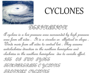
  • 1. CYCLONES DEFINATION A cyclone is a low pressure area surrounded by high pressure area form all sides . It is a circular or elliptical in shape . Winds move from all sides to central low . They assume anticlockwise direction in the northern hemisphere and clockwise in the southern hemisphere due to cariolis effect. ITS OF TWO TYPES TEMPARERATE C YCLONE TROPICAL CYCLONE
  • 2. CHARACTERSTICS OF CYCLONES To make the most efficient analysis of available data in the vicinity of typhoon, you must be familiar with the normal wind, pressure, temperature, clouds and weather pattern associated with these storms. 1.SURFACE WINDS The surface winds blow inward in a counterclockwise direction toward the center. The winds in the left-rear quadrant have the greatest angle of inflow (in the Northern Hemisphere). The diameter of the area affected by hurricane or typhoon force winds may be in excess of 100 miles in large storms or as small as 25 to 35 miles. Gale-force winds sometimes cover an area 500 to 800 miles or more. The maximum extent of strong winds is usually in the direction of the major subtropical high-pressure center, which is most frequently found to the right of the storm’s path in the Northern Hemisphere. Surface wind speeds of 140 knots have been successfully recorded, but accurate measurements of peak wind speeds in large mature storms have not been possible with any reliable degree of accuracy.
  • 3. CHARACTERSTICS OF CYCLONES • SURFACE PRESSURE.— The sea-level isobars are an excellent tool with which to analyze these storms. The isobars take on a nearly symmetrical or elliptical shape, although deformations in the isobaric pattern are not uncommon. For instance, the tightest isobaric spacing (strongest pressure gradient) is found to the right of a storm’s line of movement, and a trough often extends southward from these storms. The central pressures of mature storms are well below average. Central pressures of 890 to 930 millibars are not uncommon.
  • 4. CHARACTERSTICS OF CYCLONES • SURFACECE TEMPERATURE.— In contrast to extratropical cyclones, the tropical cyclone may show no cooling, or very little, toward the storm center. This indicates that the horizontal adiabatic cooling caused by lower pressures is largely offset by the heat added through the condensation process. Upper-air temperatures have been found warmer by 5 ‘C or more. • CLOUDS.— The cloud patterns of tropical cyclones also differ from those of extratropical cyclones. In mature tropical cyclones, almost all the cloud forms are present, but by and large the most significant clouds are the heavy cumulus and cumulonimbus which spiral inward toward the outer edge of the eye. These spiral bands, especially the leading ones, are also referred to as BARS. Cirrus and Cirrostratus occupy the largest portion of the sky over these storms. In fact, cirrus, becoming more dense, then changing to cirrostratus and lowering somewhat is more often than not a mariner’s first indication of an approaching distant storm or the development of one in the near vicinity. The appearance of the sky is very similar to that of an approaching warm front. A typical cloud distribution chart for a tropical cyclone is found in figure 9-3-7.
  • 5. CHARACTERSTICS OF CYCLONES THE EYE.— The eye of a storm is one of the oddest phenomena known in meteorology. Precipitation ceases abruptly at the boundary of a well-developed eye; the sky partly clears; the sun or stars become visible; the wind subsides to less than 15 knots, and at times there is a dead calm. In mature storms, the eye’s diameter averages about 15 miles, but it may attain 40 miles in large typhoons. The eye is not always circular; sometimes it becomes elongated and even diffuse with a double structure appearance. The eye is constantly undergoing transformation and does not stay in a steady state.
  • 6. INTENSITY CLASSIFICATION • A tropical depression is the lowest category that the Japan Meteorological Agency uses and is the term used for a tropical system that has wind speeds not exceeding 33 knots (38 mph; 61 km/h).[7] A tropical depression is upgraded to a tropical storm should its sustained wind speeds exceed 34 knots (39 mph; 63 km/h). Tropical storms also receive official names from RSMC Tokyo.[7] Should the storm intensify further and reach sustained wind speeds of 48 knots (55 mph; 89 km/h) then it will be classified as a severe tropical storm.[7] Once the system's maximum sustained winds reach wind speeds of 64 knots (74 mph; 119 km/h), the JMA will designate the tropical cyclone as a typhoon—the highest category on its scale.[7] • From 2009 the Hong Kong Observatory started to further divide typhoons into three different classifications: typhoon, severe typhoon and super typhoon.[8] A typhoon has wind speed of 64-79 knots (73-91 mph; 118-149 km/h), a severe typhoon has winds of at least 80 knots (92 mph; 150 km/h), and a super typhoon has winds of at least 100 knots (120 mph; 190 km/h).[8] The United States' Joint Typhoon Warning Center (JTWC) unofficially classifies typhoons with wind speeds of at least 130 knots (67 m/s; 150 mph; 241 km/h)—the equivalent of a strong Category 4 storm in the Saffir-Simpson scale—as super typhoons.[9] However, the maximum sustained wind speed measurements that the JTWC uses are based on a 1-minute averaging period, akin to the U.S.' National Hurricane Center and Central Pacific Hurricane Center. As a result, the JTWC's wind reports are higher than JMA's measurements, as the latter are based on a 10-minute averaging interval.[10]
  • 7. INTENSITY CLASSIFICATION CATEGORY SUBSTAINED WINDS TYPHOON 64 – 84 KNOTS 118 - 156 KM/H SEVERE TROPICAL STORM 48 - 63 KNOTS 89 - 117 KM/H TROPICAL STORM 34 -47 KNOTS 62 - 88 KM/H TROPICAL DISPERSION < 33 KNOTS < 61 KM/H
  • 8. FORMATION OF CYCLONES • In tropical oceans, the water in the oceans' surface layer heated by the direct solar radiation. As a result, the air above the tropical oceans is characterized by high temperature and humidity, resulting in air inflation that easily leads to low density per unit volume of air. Weak wind near the equator causes the lighter air to soar and incur convection that further attracts inflow of surrounding cooler air. The intake air then warms up and soars again, creating a positive feedback cycle that eventually forms an air column with high temperature, light weight and low density. This is how the tropical depression forms. • The air flows from high pressure towards low pressure as if the water flows from high to low elevation. The surrounding air with higher pressure will flow towards where the pressure is lower, creating the "wind." As the area for direct solar radiation moves northward away from the equator in summer, the southeasterly trade wind in the Southern Hemisphere crosses the equator and penetrates into the Northern Hemisphere in the form of southwest monsoon, which has heads-on encounter with the northeasterly trade wind in the Northern Hemisphere and forces the air in this area to soar, creating more convection. Furthermore, the wind convergence resulting from the southwesterly and the northeasterly trade winds often cause air turbulence and whirlpool. These convergence effects, when continually enhanced by the convection activity, further deepens the existing low-pressure vortex, resulting in more and faster ambient air flow been drawing into the vortex center. Faster inflow corresponds to higher wind speed which, when the near-ground maximum speed reaches or exceeds 62 km per hour or 17.2 meter per second, is characteristic of a typhoon.
  • 10. NAMING OF CYCLONES • Tropical cyclones have officially been named since 1945 and are named for a variety of reasons, which include to facilitate communications between forecasters and the public when forecasts, watches, and warnings are issued. Names also reduce confusion about what storm is being described, as more than one can occur in the same region at the same time.[1] The official practice of naming tropical cyclones started in 1945 within the Western Pacific and was gradually extended out until 2004, when the Indian Meteorological Department started to name cyclonic storms within the North Indian ocean. Names were first given to storms by Australian meteorologist Clement Wragge from 1887, Before the official practice of naming of tropical cyclones began, significant tropical cyclones were named after annoying politicians, mythological creatures, saints and place names. Names are drawn in order from predetermined lists (see Lists of tropical cyclone names) and are usually assigned to tropical cyclones with one-, three-, or ten-minute sustained wind speeds of more than 65 km/h (40 mph) depending on which area it originates. However, standards vary from basin to basin with some tropical depressions named in the Western Pacific, while within the Southern Hemisphere tropical cyclones have to have a significant amount of gale-force winds occurring around the center before they are named.
  • 11. EFFECTS OF CYCLONES • The main effects of tropical cyclones include heavy rain, strong wind, large storm surges at landfall, and tornadoes. The destruction from a tropical cyclone depends mainly on its intensity, its size, and its location. Tropical cyclones act to remove forest canopy as well as change the landscape near coastal areas, by moving and reshaping sand dunes and causing extensive erosion along the coast. Even well inland, heavy rainfall can lead to mudslides and landslides in mountainous areas. Their effects can be sensed over time by studying the concentration of the Oxygen-18 isotope within caves within the vicinity of cyclones' paths. • After the cyclone has passed, devastation often continues. Standing water can cause the spread of disease, and transportation or communications infrastructure may have been destroyed, hampering clean-up and rescue efforts. Nearly two million people have died globally due to tropical cyclones. Despite their devastating effects, tropical cyclones are also beneficial, by potentially bringing rain to dry areas and moving heat from the tropics poleward. Out at sea, ships take advantage of their known characteristics by navigating through their weaker, western half.
  • 12. EFFECTS OF CYCLONES AT SEA • A mature tropical cyclone can release heat at a rate upwards of 6x10¹⁴ watts.[1] Tropical cyclones on the open sea cause large waves, heavy rain, and high winds, disrupting international shipping and, at times, causing shipwrecks.[2] Generally, after its passage, a tropical cyclone stirs up ocean water, lowering sea surface temperatures behind it.[3] This cool wake can cause the region to be less favorable for a subsequent tropical cyclone. On rare occasions, tropical cyclones may actually do the opposite. 2005's Hurricane Dennis blew warm water behind it, contributing to the unprecedented intensity of Hurricane Emily, which followed it closely.[4] Hurricanes help to maintain the global heat balance by moving warm, moist tropical air to the mid-latitudes and polar regions.[5] Were it not for the movement of heat poleward (through other means as well as hurricanes), the tropical regions would be unbearably hot.
  • 13. EFFECTS OF CYCLONES STORM SURGE • The aftermath of Hurricane Katrina in Gulfport, Mississippi. Katrina was the costliest tropical cyclone in United States history. • See also: Storm surge • The storm surge, or the increase in sea level due to the cyclone, is typically the worst effect from landfalling tropical cyclones, historically resulting in 90% of tropical cyclone deaths.[13] The relatively quick surge in sea level can move miles/kilometers inland, flooding homes and cutting off escape routes. The storm surges and winds of hurricanes may be destructive to human-made structures, but they also stir up the waters of coastal estuaries, which are typically important fish breeding locales.
  • 14. EFFECTS OF CYCLONES HEAVY RAINFALL • The thunderstorm activity in a tropical cyclone produces intense rainfall, potentially resulting in flooding, mudslides, and landslides. Inland areas are particularly vulnerable to freshwater flooding, due to residents not preparing adequately.[14] Heavy inland rainfall eventually flows into coastal estuaries, damaging marine life in coastal estuaries.[15] The wet environment in the aftermath of a tropical cyclone, combined with the destruction of sanitation facilities and a warm tropical climate, can induce epidemics of disease which claim lives long after the storm passes.[13] Infections of cuts and bruises can be greatly amplified by wading in sewage-polluted water. Large areas of standing water caused by flooding also contribute to mosquito-borne illnesses. Furthermore, crowded evacuees in shelters increase the risk of disease propagation.[13] • Flooding in Seminole County, Florida from Tropical Storm Fay (2008) • Although cyclones take an enormous toll in lives and personal property, they may be important factors in the precipitation regimes of places they affect and bring much-needed precipitation to otherwise dry regions. Hurricanes in the eastern north Pacific often supply moisture to the Southwestern United States and parts of Mexico.[16] Japan receives over half of its rainfall from typhoons.[17] Hurricane Camille averted drought conditions and ended water deficits along much of its path,[18] though it also killed 259 people and caused $9.14 billion (2005 USD) in damage.
  • 15. EFFECTS OF CYCLONES DEATHS • During the last two centuries, tropical cyclones have been responsible for the deaths of about 1.9 million people worldwide. It is estimated that 10,000 people per year perish due to tropical cyclones.[21] The deadliest tropical cyclone was the 1970 Bhola cyclone, which had a death toll of anywhere from 300,000 to 500,000 lives.
  • 16. EFFECTS OF CYCLONES RECONSTURCTION AND REPOUPLATION • Aerial image of destroyed homes in Punta Gorda, Florida, following Hurricane Charley • While tropical cyclones may well seriously damage settlement, total destruction encourages rebuilding. For example, the destruction wrought by Hurricane Camille on the Gulf coast spurred redevelopment, greatly increasing local property values.[18] Research indicates that the typical hurricane strike raises real house prices for a number of years, with a maximum effect of between 3 percent to 4 percent three years after occurrence.[25] However, disaster response officials point out that redevelopment encourages more people to live in clearly dangerous areas subject to future deadly storms. Hurricane Katrina is the most obvious example, as it devastated the region that had been revitalized after Hurricane Camille. Many former residents and businesses do relocate to inland areas away from the threat of future hurricanes as well.
  • 19. TRACKS AND AREAS OF CYCLONES • Tropical cyclones are more active in summer . Their areas of activity is the tropical zone. • The following are some of the characteristics of the tracks of a cyclones : • 1. Between the equator and 15°latitude, these storms turn towards the west with the trades. • 2. Between 15° and 30° latitude the path is very uncertain. But these travel towards the north in the northern hemisphere and the south in the southern hemisphere. • 3. As these cross 30° latitude they turn towards the east and take much of the character of the temperate cyclone . Their terrific energy also declines.
  • 20. DIFFERENT NAMES OF CYCLONES IN DIFFERENT COUNTRIES • The chief areas of activity for the cyclone are the following : • 1. West Indies and the Coast of Florida. In that region these are known as HURRICANES. • 2. Philippine Islands, the coasts of China and Japan. These are known as TYPHOONS. • 3. Bay of Bengal and the Arabian Sea, where these are known as CYCLONES. • 4. Madagascar and the coastal regions of East Africa. • 5. Northeast and Northwestern coasts of Australia, where they are called WELLY-WELLIES. • They are known as TORNADOES in the U.S.A. and Mexico.
  • 21. HISTORIC LIST • Tropical cyclones are named for historical reasons and so to avoid confusion when communicating with the public as more than one tropical cyclone can exist at a time. Names are drawn in order from predetermined lists and are usually assigned to tropical cyclones with one, three or ten minute wind speeds of more than 65 km/h (40 mph). However standards vary from basin to basin with some tropical depressions named in the Western Pacific whilst tropical cyclones have to have gale force winds occurring more than halfway around the center within the Australian and Southern Pacific regions. • The official practice of naming tropical cyclones started in 1945 within the Western Pacific. Naming continued through the next few years before in 1950, names also started to be assigned to tropical storms forming in the North Atlantic ocean. In the Atlantic, names were originally taken from the world war two version of the Phonetic Alphabet but this was changed in 1953 to use lists of women names which were drawn up yearly. Around this time naming of tropical cyclones also began within the Southern and Central parts of the Pacific. However naming didn't begin the Eastern Pacific until 1960 with the original naming lists designed to be used year after year in sequence. In 1960, naming also began in the Southwest Indian Ocean before in 1963 the Philippine Meteorological Service, started assigning names to tropical cyclones that moved into or formed in their area of responsibility. Later in 1963 warning centers within the Australian region also commenced naming tropical cyclones.
  • 22. HISTORIC LIST • NORTH ATLANTIC • By 1950 tropical cyclones that were judged by the US Weather Bureau to have intensified into a tropical storm, started to be assigned names.[1][2] Storms were originally named in alphabetical order using the World War II version of the Phonetic Alphabet.[1] By 1952 a new phonetic alphabet had been developed and this led to confusion as some parties wanted to use the newer phonetic alphabet.[1] In 1953, to alleviate any confusion, forecasters decided to use a set of 23 feminine names.[1][2] After the 1953 Atlantic hurricane season, public reception to the idea seemed favorable, so the same list was adopted for the next year with one change; Gilda for Gail.[1] However after storms like Carol and Hazel got a lot of publicity during the 1953 season, forecasters agreed to develop a new set of names for 1955.[1] However before this could happen, a tropical storm was declared significant on January 2, 1955 and was named as Alice.[1] The new set of names were developed and used in 1955 beginning with Brenda continuing through the alphabet to Zelda.[1] For each season before 1960, a new set of names were developed.[1] In 1960 forecasters decided to begin rotating names in a regular sequence and thus four alphabetical lists were established to be repeated every four years.[3] The sets followed the example of the western Pacific typhoon naming lists and excluded names beginning with the letters Q, U, X, Y and Z.[3] These four lists were used until 1972 when the National Oceanic and Atmospheric Administration (NOAA), replaced them with 9 lists designed to be used from 1972.[3] In 1977, NOAA made the decision to relinquish control over the name selection by allowing a regional committee of the World Meteorological Organization to select the new sets of names which would contain male names and some Spanish and French names in order to reflect all the cultures and languages within the Atlantic Ocean.[2][3] The World Meteorological Organization decided that the new lists of hurricane name would start to be used in 1979.[2][3] Since 1979 the same lists have been used, with names of significant tropical cyclones removed from the lists and replaced with new names.[2] In 2002 Subtropical Cyclones started to be assigned names from the main list of names set up for that year. In 2005 as all the names preselected for the season were exhausted, the contingency plan of using Greek letters for names had to be used.[4] Since then there have been a few attempts to get rid of the Greek names, as they are seen to be inconsistent with the standard naming convention used for tropical cyclones and are considered generally unknown and confusing to the public.[5] However the lists of preselected names for the year, are not expected to be used up frequently enough to warrant any change in the existing naming procedure and thus the Greek Alphabet will be used if the list of pre selected names should ever be used up again.[5][6][7]
  • 23. HISTORIC LIST • EASTERN PACIFIC • Within the Eastern Pacific basin between the western coasts of the Americas and 140°W the naming of tropical cyclones started in 1960, with four lists of female names initially designed to be used consecutively before being repeated.[31][32] In 1965 after two lists of names had been used, it was decided to return to the top of the second list and to start recycling the sets of names on an annual basis.[32][33] • In 1977, after protests by various women's rights groups, NOAA made the decision to relinquish control over the name selection by allowing a regional committee of the World Meteorological Organization (WMO) to select new sets of names.[3] The WMO selected six lists of names which contained male names and rotated every six years.[3] They also decided that the new lists of hurricane name would start to be used in 1978 which was a year earlier than the Atlantic.[34] Since 1978 the same lists of names have been used, with names of significant tropical cyclones removed from the lists and replaced with new names.[32] As in the Atlantic basin should the names preselected for the season be exhausted, the contingency plan of using Greek letters for names would be used.[32][35] However unlike in the Atlantic basin the contingency plan has never had to be used, although in 1985 to avoid using the contingency plan, the letters X, Y, and Z were added to the lists.[35] Since the contingency plan had to be used in the North Atlantic during 2005 there have been a few attempts to get rid of the Greek names as they are seen to be inconsistent with the standard naming convention used for tropical cyclones and are generally unknown and confusing to the public.[5][6] However none of the attempts have succeeded and thus the Greek letters will be used should the lists be used up.[5][6]
  • 24. HISTORIC LIST WESTERN NORTH PACIFIC • In the Western North Pacific ocean, there are two sets of names generally used. The first are the international names assigned to a tropical cyclone by the Japan Meteorological Agency (JMA) or the Joint Typhoon Warning Center (JTWC). The second set of names are local names assigned to a tropical cyclone by the Philippine Atmospheric, Geophysical and Astronomical Services Administration. This system often ends up with a tropical cyclone being assigned two names, should a tropical storm threaten the Philippines. • On January 1, 2000 the Japan Meteorological Agency as the official Regional Specialized Meteorological Center took over the naming of Tropical storms. The names selected by the World Meteorological Organization's Typhoon Committee were from a pool of names submitted by the various countries that make up the Typhoon Committee.
  • 25. HISTORIC LIST • CENTRAL NORTH PACIFIC • In 1950 a tropical cyclone that affected Hawaii was named Able, after a tropical cyclone had not affected Hawaii for a number of years.[40][41] The system subsequently became widely known as Hurricane Hiki, since Hiki is Hawaiian for Able.[40][41] Typhoons Olive and Della of 1952 and 1957 developed within the Central Pacific, but were not named until they had crossed the International Dateline and moved into the Western Pacific basin.[40][42] During 1957, two other tropical cyclones developed in the Central Pacific and were named Kanoa and Nina, by the Hawaiian military meteorological offices.[42] It was subsequently decided that future tropical cyclones, would be named by borrowing names from the Western Pacific naming lists.[42] During 1979, after ten names had been borrowed from the Western Pacific naming lists, Hawaiian names were reinstated for tropical cyclones developing into tropical storms forming in the Central Pacific.[33] Five sets of Hawaiian names, using only the 12 letters of the Hawaiian alphabet, were drafted with the intent being to use the sets of names on an annual rotation basis.[33] However, after no storms had developed in this region between 1979 and 1981, the annual lists were scrapped and replaced with four sets of names and designed to be used consecutively.[33] Ahead of the 2007 hurricane season, the Central Pacific Hurricane Center (CPHC) introduced a revised set of Hawaiian names for the Central Pacific, after they had worked with the University of Hawaii Hawaiian Studies Department to ensure the correct meaning and appropriate historical and cultural use of the names.[43]
  • 26. HISTORIC LIST • PHILIPPINES • Since 1963, the Philippine Atmospheric, Geophysical and Astronomical Services Administration (PAGASA), have assigned their own names to typhoons that pass through its area of responsibility.[45] Unlike the World Meteorological Organization's standard of assigning names to tropical cyclones when they reach wind-speeds of 65 km/h, (40 mph), PAGASA assigns a name to a tropical depression when they either form or move into their area of responsibility.[45][46] Four sets of tropical cyclone names are rotated annually with typhoon names stricken from the list should they do more than 1 billion Pesos worth of damage to the Philippines and/or cause 300 or more deaths.[47][48] Should the list of names for a given year prove insufficient, names are taken from an auxiliary list.[47]
  • 27. HISTORIC LIST • NORTH INDIAN OCEAN • During its annual session in 2000 the WMO/ESCAP Panel on North Indian tropical cyclones, agreed in principle to start assigning names to Cyclonic Storms that developed within the North Indian Ocean.[61][62] As a result the panel requested that each member country submit a list of ten names to a rapporteur by the end of the year 2000.[62] At the 2001 session of the Panel, the rapporteur reported that seven of the eight countries had submitted their names.[62] However, India had refused to submit a list of names, as it had some reservations about assigning names to tropical cyclones, due to the regional, cultural and lingustic diverstiy of the panel members.[62] The panel subsquently studied the names and felt that some of the names would not be appealing to the public or the media, and requested that members submit new lists of names.[62] At the following years session the rapporteur reported that there had been a poor response by member countries in resubmitting their lists of names.[62] In response the panel felt that it was important that the work continued and urged the members to copperate and submit their names to the rapporteur.[62] The names were subsquently submitted in time for the 2004 session, however, India had still not submitted their names, despite promising to do so.[62] The rapporteur presented the 4 lists of names that would be used with a gap left for India's names and recommended that the India Meteorological Department's Regional Specialised Meterological Centre in New Delhi name the systems.[62] The rapporteur also recommended that the naming lists were used on an experimental basis during the season, starting in May or June 2004 and that the lists should only be used until 2009 when a new list would be drawn up for the following ten years.[62] The naming lists were then completed in May 2004, after India submitted their names, however the lists were not used until September 2004 when the first tropical cyclone was named Onil by India Meteorological Department.[61][63]
  • 28. PLANS FOR DETECTION • Because of the forces that affect tropical cyclone tracks, accurate track predictions depend on determining the position and strength of high- and low-pressure areas, and predicting how those areas will change during the life of a tropical system. The deep layer mean flow, or average wind through the depth of the troposphere, is considered the best tool in determining track direction and speed. If storms are significantly sheared, use of wind speed measurements at a lower altitude, such as at the 70 kPa pressure surface (3,000 metres or 9,800 feet above sea level) will produce better predictions. Tropical forecasters also consider smoothing out short-term wobbles of the storm as it allows them to determine a more accurate long-term trajectory.[107] High-speed computers and sophisticated simulation software allow forecasters to produce computer models that predict tropical cyclone tracks based on the future position and strength of high- and low-pressure systems. Combining forecast models with increased understanding of the forces that act on tropical cyclones, as well as with a wealth of data from Earth-orbiting satellites and other sensors, scientists have increased the accuracy of track forecasts over recent decades.[108] However, scientists are not as skillful at predicting the intensity of tropical cyclones.[109] The lack of improvement in intensity forecasting is attributed to the complexity of tropical systems and an incomplete understanding of factors that affect their development.
  • 29. MANAGEMENT OF CYCLONES • Cyclone, tropical cyclone, hurricane, and typhoon are different names for the same phenomenon a cyclonic storm system that forms over the oceans. The deadliest hurricane ever was the 1970 Bhola cyclone; the deadliest Atlantic hurricane was the Great Hurricane of 1780 which devastated Martinique, St. Eustatius and Barbados. Another notable hurricane is Hurricane Katrina which devastated the Gulf Coast of the United States in 2005.
  • 30. MANAGEMENT OF CYCLONES • An effective disaster management system consists of four main components — disaster prediction, disaster warning, disaster management and disaster relief. Disaster warning is a basic prerequisite for ensuring disaster preparedness and in some cases to help in the prevention of disaster itself. Clearly the most important application of satellites is in detecting, predicting and delivering early warning of impending disasters such as flood, drought, cyclone and even forest fires (Rao et al. 1987; Heath 1994). Continuous monitoring by both geostationary and low earth orbiting weather satellites like GOES, INSAT, METEOSAT and NOAA is capable of providing early warning on cyclones and floods. Forest fires, environmental hazards, volcanic eruptions and even propagation of desert locust phenomena can be detected well in time by remote sensing satellites like, LANDSAT, SPOT and IRS. Sustainable development strategy must address this important issue in order to provide stability and reasonable security to the vulnerable rural population in these countries. Remote sensing information are now operationally used to regularly monitor flood conditions, volume of water flow and damage assessment. From such a database collected over years, it is possible to identify different risk zones in the flood prone area based on the severity index for flood proneness of each zone. Optimal treatment of each zone on a long term basis, depending on the severity, can then be attempted to achieve reduction in flood damage without impairing environmental integrity (Rao 1993)