This document provides tips for using the search function in OneNote. It describes how to select the scope of a search, such as a specific page, section, or notebook. Search results can be refined by sorting by section, title, or date modified. Advanced search tips include using quotation marks to search for exact matches, and using operators like AND and OR to combine search terms. OneNote's search also works on text within inserted images or printouts.
The document describes H5P's interactive book tool, which allows instructors to create interactive books with multiple pages of content. Students can access pages through a menu and each page has its own URL. The tool guides how to add a book cover, pages with different interactive content types, and display options. It also describes the student and teacher experience, with students completing interactive elements on pages and teachers able to view student attempts and reports.
Final Report for Automatic Wall Painting Brush, Student Creativity and Technology Application Program (Program Kreativitas Mahasiswa Penerapan Teknologi), 2008
Voyager is a feature available at the Google Earth site. It can be used to encourage learners to dive deeper into topic while providing learners with linkages to global locations. This guide introduces 3 different ways to use to explore indigenous peoples, lands and cultures.
This document outlines a virtual tour lesson on volcanoes using Google Earth. Students will visit several famous volcanoes and complete a chart about each one. They will then choose one volcano to create an informational brochure or poster about to share what they learned. The lesson aims to help students recognize different volcano types, locations, and the geological processes that cause volcanic eruptions.
This document provides 25 tips for using Google Earth in the classroom, as shared by various educators. Some of the tips include using Google Earth to look at field trip locations before visiting; embedding videos and media into placemarks; using lines and paths to measure distances; slowing down the zoom speed to allow more time to observe details; and overlaying historic maps to see landscape changes over time. The tips cover uses in various subjects from science to literature to history. The document encourages sharing additional tips on how Google Earth can be utilized as an educational tool.
This document provides an overview of Google Earth and ways it can be used in the classroom. It discusses features of Google Earth like layers, distance measurements, linking additional content, and creating paths and tours. Examples are given of how Google Earth has been used to teach about the American Revolution, climate, and frogs. Directions are provided for adding placemarks, images, videos and creating screen overlays. Resources for lesson plans and help with Google Earth are also listed.
This document provides an overview of Google Earth and suggestions for how to use it in the classroom. It discusses what Google Earth is, its features like layers and tools, and examples of lessons on topics like the American Revolution, climate, and frogs that incorporate Google Earth. It also demonstrates how to add placemarks, images, videos and create tours using Google Earth for educational projects.
This document provides an overview of Google Earth and ways it can be used in the classroom. It discusses features of Google Earth like layers, distance measurements, linking additional content, and creating paths and tours. Examples are given of how Google Earth has been used to teach about the American Revolution, climate, and frogs. Directions are provided for adding placemarks, images, videos and creating screen overlays. Resources for lesson plans and help with Google Earth are also listed.
This is a worksheet that students can follow to familiarize themselves with the app google Expeditions. The worksheet provides learners guidance on how the App can be used as well as give them some responsibility to complete a basic task.
The document provides information about plate tectonics and volcanic activity. It includes sections on Alfred Wegener and his theory of continental drift, the formation of supercontinents like Pangea, demonstrations of plate tectonics using Oreo cookies, the rock cycle, types of rocks, earthquakes and the Richter scale, making a model volcano, volcanic features, and tsunamis. The document contains images to label, questions to answer, and instructions for hands-on activities like creating an erupting volcano model using plaster of paris.
Google Earth is a mapping tool that allows users to view satellite imagery and 3D models of locations around the world. It has many features that can be used in the classroom, such as layers that integrate additional data, distance measurement tools, and the ability to embed videos, images and websites in user-created placemarks and tours. Examples provided demonstrate how students have used Google Earth for virtual field trips to study frogs on different continents and to collaboratively report on climate and weather from regions around the world. The document provides guidance on how to incorporate tools like placemarks, polygons and overlays into lessons to engage students and help them conceptualize geographic concepts.
Google Earth allows users to view locations around the world, take virtual tours, and see driving directions. Additional features include viewing layers of information about places, 3D terrain modeling, and a flight simulator. The toolbar provides tools for navigation, zooming, and sharing content.
This document appears to be from a geography textbook and covers several key concepts:
- Geography studies both physical features of the Earth as well as human activities and interactions with the environment.
- Geographers use tools like maps and measurements to describe locations, regions, ecosystems, and relationships between places.
- Locations can be described in absolute or relative terms, and regions include formal, functional, and perceptual types based on shared characteristics.
- Physical systems and human activities both shape the Earth's surface and environments over time through migration, trade, and adaptation to barriers.
1. The document provides details on idea development for a factual production piece, including mind maps of topics, ideas, images, and existing design work.
2. It discusses initial font ideas and overall and alternative color schemes to convey information and emotion.
3. The proposed structure explains setting up both sides of an argument about the costs and benefits of space travel, looking at relevant facts, figures, and technologies to argue that space travel is important.
This document provides examples of how to integrate Google Earth into different subject areas such as social studies, English, math, science, art, and music by using features like street view, measuring tools, and viewing locations to enhance lessons. Teachers can use Google Earth to take virtual field trips, study architecture and landscapes, analyze distances and conversions, explore astronomy and ocean features, and learn about composers and their works. Google Earth provides an engaging way for students to visually experience curriculum content.
Laura Wilson, a reference librarian, presented on using the free software Google Earth for educational purposes. Google Earth allows users to virtually explore terrain, buildings, places of interest, and photos/videos from locations around the world. Teachers have used Google Earth across many disciplines by having students independently explore locations or through tours with embedded images and audio. Google Earth provides opportunities for curiosity, exploration, and discovery beyond typical lessons.
This document provides research and planning materials for a video about the benefits of space travel and exploration. It includes mind maps and mood boards exploring design ideas, as well as research on topics like the US space budget, technologies derived from NASA research, how the International Space Station benefits life on Earth, and arguments for and against space exploration. The document outlines the intended structure of the video to provide background on both sides of the debate before making the case that space travel benefits humanity through areas like technology and medical research.
Nihonmachi by Edna Kovacs, Ph.D. and Elizabeth ThielPoetinEden
Urban renewal. Many of the original buildings have been replaced by newer
construction. Some of the same buildings remain, like the one on the northwest corner with the
arches, but most have been replaced.
Part One, Segment Two:
3. NW 9th Avenue & Everett Street
• What is the name of the building on the southwest corner?
• What was this building originally used for?
• What is it used for now?
4.
1) The document discusses how to integrate Google Earth and multimedia to create interactive literary stories for the classroom.
2) Teachers can choose a story with a strong sense of place and develop activities that involve different locations. Placemarks in Google Earth can include text, images, videos and audio to visualize information.
3) The interactive maps and virtual field trips bring characters and stories to life for engaged student learning. Teachers are invited to learn how to create their own Google Lit Trips lessons.
The document describes a proposed mobile application called the World of Amphibians. The app would allow children under 13 to explore different types of amphibians from around the world. Children could view information about amphibians' diets, sizes, and defenses. They could also look at photos submitted by other users through a social media feature, without directly interacting with strangers. The app's color palette and fonts are described, as are the initial user journey and screens for selecting continents and viewing the social media section.
This document provides 26 tips for using Google Earth in the classroom, beginning with using it to preview field trips and embedding media from sites like YouTube. Other tips include using measurement tools, slowing down tours to observe details, tracking leaf color changes, having students collaboratively plan and build virtual cities, finding blog visitors on a map, and using geotagged Shakespeare plays to supplement literary studies. Many tips involve using Google Earth to support geography, history, literature and other subjects.
The document provides instructions for playing Geoguessr's Daily Challenge game. It explains how to create a free Geoguessr account, select the Daily Challenge game which presents 5 random global locations, view the Street View at each location to make guesses, pin guesses on the map, view results between guesses, and see performance summaries after completing all locations.
How To Microsoft Immersive Reader for Word2019John Allan
The document provides instructions for using the immersive reader feature in Microsoft Word 2019:
1. Open a Word document and click on the Immersive Reader icon under the View menu to launch the immersive reader interface.
2. The immersive reader toolbar appears and formats the text with smaller margins and more spacing to reduce distractions and focus on the text.
3. Various settings and display options can be adjusted within the immersive reader, such as reading speed and volume, line and page formatting, and visualizing syllables.
H5P's Dictation tool allows instructors to set up listening and writing activities. An H5P dictation activity allows instructors to set up normal and slow audio for student consideration. As well, alternate spellings can be set up to ensure that students can use alternate spelling or numbers. An example of short dictation activity can be viewed https://h5p.org/dictation.
The document discusses business strategies and processes. It advocates for collaborative thinking to grow the holistic world view of disruptive innovation through workplace diversity. It also discusses capitalizing on opportunities, podcasting operational changes, and dynamically procurrastinating to draw convergence across platforms. Potential roadblocks like clicks-and-mortar solutions are addressed, as well as profiting through synergizing relationships and dynamically innovating customer service. Reflection on processes to predominate testing and engage web services is also provided.
The document provides step-by-step instructions for improving the accessibility of a Microsoft Word document. It details how to check for accessibility issues, customize text styles and structure, add alternative text descriptions to images and other non-text elements, format lists and tables for screen readers, and remove watermarks and add descriptive text to hyperlinks. The goal is to ensure the content can be understood when read aloud by a screen reader.
Qatar University Conference 2021 Interactive video W/ H5P SlidesJohn Allan
This document discusses creating interactive videos using H5P. It begins with acknowledging the traditional territories of Indigenous peoples. It then introduces John Allan and lists his credentials. The document outlines objectives to demonstrate interactive video features and generation using H5P. It provides an example H5P interactive video and lists other interactive video tools. It describes how to enhance videos with annotations, questions, and other interactions. It provides sources for finding H5P interactive videos and links to tutorials and documentation for creating them. In the end, it asks if the reader has any other questions.
This is How To document for teachers who are trying to improve their online and blended courses without purchasing complex software. Windows 10 arrives with the Photos Video Editor. It provides essential tools for teachers to edit their video for educational purposes.
This document provides instructions for editing audio files using the Audacity Online Editor Chrome Extension. It describes how to upload and import audio clips, select portions of audio to edit, add silence or apply effects like normalization and fading. Editing techniques covered include cropping, removing tracks, and using the envelope tool to adjust volume over time. The document explains how to export edited audio files from the online editor.
This is a revised session hand out that introduces the basics of image editing to educators. PIXLR Editor is used because, it is Free, intuitive and online.
This document discusses using Adobe InDesign for rapid development of instructor guides and student workbooks. It outlines how InDesign features like templates, master pages, styles, and libraries can help with consistency and reuse. The team used InDesign along with linked Creative Cloud apps like Illustrator, Photoshop, and Acrobat to lay out over 100 guides and workbooks for publishing online. Through templates, common elements, and collaboration tools in InDesign, the team was able to efficiently produce the materials despite having low experience.
Professional Learning Network 2021 hand outJohn Allan
This hand out is relevant for those who want to start a PLN. A Professional Learning Network (PLN) means different things to different people. In simple terms, your network includes the people or sources that contribute to your professional and lifelong learning. A PLN may be used by teaching professionals to access resources and ideas, develop skills and lessons, and connect with others in the profession. In your PLN, you can include subject specific experts, websites, social media resources, online or face-to-face groups, conferences or learning communities.
A Quizlet feature, diagrams, allows learners to choose vocabulary based on a mosaic or scenic image. This is one more useful earning experience on their way to acquiring vocabulary. This how to sheet should get instructors started to using this tool.
Main Java[All of the Base Concepts}.docxadhitya5119
This is part 1 of my Java Learning Journey. This Contains Custom methods, classes, constructors, packages, multithreading , try- catch block, finally block and more.
How to Make a Field Mandatory in Odoo 17Celine George
In Odoo, making a field required can be done through both Python code and XML views. When you set the required attribute to True in Python code, it makes the field required across all views where it's used. Conversely, when you set the required attribute in XML views, it makes the field required only in the context of that particular view.
हिंदी वर्णमाला पीपीटी, hindi alphabet PPT presentation, hindi varnamala PPT, Hindi Varnamala pdf, हिंदी स्वर, हिंदी व्यंजन, sikhiye hindi varnmala, dr. mulla adam ali, hindi language and literature, hindi alphabet with drawing, hindi alphabet pdf, hindi varnamala for childrens, hindi language, hindi varnamala practice for kids, https://www.drmullaadamali.com
Reimagining Your Library Space: How to Increase the Vibes in Your Library No ...Diana Rendina
Librarians are leading the way in creating future-ready citizens – now we need to update our spaces to match. In this session, attendees will get inspiration for transforming their library spaces. You’ll learn how to survey students and patrons, create a focus group, and use design thinking to brainstorm ideas for your space. We’ll discuss budget friendly ways to change your space as well as how to find funding. No matter where you’re at, you’ll find ideas for reimagining your space in this session.
How to Setup Warehouse & Location in Odoo 17 InventoryCeline George
In this slide, we'll explore how to set up warehouses and locations in Odoo 17 Inventory. This will help us manage our stock effectively, track inventory levels, and streamline warehouse operations.
A review of the growth of the Israel Genealogy Research Association Database Collection for the last 12 months. Our collection is now passed the 3 million mark and still growing. See which archives have contributed the most. See the different types of records we have, and which years have had records added. You can also see what we have for the future.
This slide is special for master students (MIBS & MIFB) in UUM. Also useful for readers who are interested in the topic of contemporary Islamic banking.
Chapter wise All Notes of First year Basic Civil Engineering.pptxDenish Jangid
Chapter wise All Notes of First year Basic Civil Engineering
Syllabus
Chapter-1
Introduction to objective, scope and outcome the subject
Chapter 2
Introduction: Scope and Specialization of Civil Engineering, Role of civil Engineer in Society, Impact of infrastructural development on economy of country.
Chapter 3
Surveying: Object Principles & Types of Surveying; Site Plans, Plans & Maps; Scales & Unit of different Measurements.
Linear Measurements: Instruments used. Linear Measurement by Tape, Ranging out Survey Lines and overcoming Obstructions; Measurements on sloping ground; Tape corrections, conventional symbols. Angular Measurements: Instruments used; Introduction to Compass Surveying, Bearings and Longitude & Latitude of a Line, Introduction to total station.
Levelling: Instrument used Object of levelling, Methods of levelling in brief, and Contour maps.
Chapter 4
Buildings: Selection of site for Buildings, Layout of Building Plan, Types of buildings, Plinth area, carpet area, floor space index, Introduction to building byelaws, concept of sun light & ventilation. Components of Buildings & their functions, Basic concept of R.C.C., Introduction to types of foundation
Chapter 5
Transportation: Introduction to Transportation Engineering; Traffic and Road Safety: Types and Characteristics of Various Modes of Transportation; Various Road Traffic Signs, Causes of Accidents and Road Safety Measures.
Chapter 6
Environmental Engineering: Environmental Pollution, Environmental Acts and Regulations, Functional Concepts of Ecology, Basics of Species, Biodiversity, Ecosystem, Hydrological Cycle; Chemical Cycles: Carbon, Nitrogen & Phosphorus; Energy Flow in Ecosystems.
Water Pollution: Water Quality standards, Introduction to Treatment & Disposal of Waste Water. Reuse and Saving of Water, Rain Water Harvesting. Solid Waste Management: Classification of Solid Waste, Collection, Transportation and Disposal of Solid. Recycling of Solid Waste: Energy Recovery, Sanitary Landfill, On-Site Sanitation. Air & Noise Pollution: Primary and Secondary air pollutants, Harmful effects of Air Pollution, Control of Air Pollution. . Noise Pollution Harmful Effects of noise pollution, control of noise pollution, Global warming & Climate Change, Ozone depletion, Greenhouse effect
Text Books:
1. Palancharmy, Basic Civil Engineering, McGraw Hill publishers.
2. Satheesh Gopi, Basic Civil Engineering, Pearson Publishers.
3. Ketki Rangwala Dalal, Essentials of Civil Engineering, Charotar Publishing House.
4. BCP, Surveying volume 1
LAND USE LAND COVER AND NDVI OF MIRZAPUR DISTRICT, UPRAHUL
This Dissertation explores the particular circumstances of Mirzapur, a region located in the
core of India. Mirzapur, with its varied terrains and abundant biodiversity, offers an optimal
environment for investigating the changes in vegetation cover dynamics. Our study utilizes
advanced technologies such as GIS (Geographic Information Systems) and Remote sensing to
analyze the transformations that have taken place over the course of a decade.
The complex relationship between human activities and the environment has been the focus
of extensive research and worry. As the global community grapples with swift urbanization,
population expansion, and economic progress, the effects on natural ecosystems are becoming
more evident. A crucial element of this impact is the alteration of vegetation cover, which plays a
significant role in maintaining the ecological equilibrium of our planet.Land serves as the foundation for all human activities and provides the necessary materials for
these activities. As the most crucial natural resource, its utilization by humans results in different
'Land uses,' which are determined by both human activities and the physical characteristics of the
land.
The utilization of land is impacted by human needs and environmental factors. In countries
like India, rapid population growth and the emphasis on extensive resource exploitation can lead
to significant land degradation, adversely affecting the region's land cover.
Therefore, human intervention has significantly influenced land use patterns over many
centuries, evolving its structure over time and space. In the present era, these changes have
accelerated due to factors such as agriculture and urbanization. Information regarding land use and
cover is essential for various planning and management tasks related to the Earth's surface,
providing crucial environmental data for scientific, resource management, policy purposes, and
diverse human activities.
Accurate understanding of land use and cover is imperative for the development planning
of any area. Consequently, a wide range of professionals, including earth system scientists, land
and water managers, and urban planners, are interested in obtaining data on land use and cover
changes, conversion trends, and other related patterns. The spatial dimensions of land use and
cover support policymakers and scientists in making well-informed decisions, as alterations in
these patterns indicate shifts in economic and social conditions. Monitoring such changes with the
help of Advanced technologies like Remote Sensing and Geographic Information Systems is
crucial for coordinated efforts across different administrative levels. Advanced technologies like
Remote Sensing and Geographic Information Systems
9
Changes in vegetation cover refer to variations in the distribution, composition, and overall
structure of plant communities across different temporal and spatial scales. These changes can
occur natural.
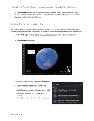
1. John Allan 2023
Using Google Earth to Connect through Language, Land & Culture Activities
The Google Earth resource can be used to encourage learners to dive deeper into topics while
providing learners with links to locations. This guide introduces different ways to use to explore
indigenous peoples, lands and cultures.
Activity 1 – Sacred Location Uluru
Set a place name or landmark that the students can search for. In this example it is Uluru, Australia.
Ensure that the learners have a worksheet or aspects of the location to record while they are exploring.
1) Go to the Google Earth by typing https://earth.google.com in the browser address bar.
The Google Earth app appears.
2) In the vertical menu bar, click on the Search icon.
3) Type the location name in the search field.
A list of locations appears below the search field.
In this case, there are also Guided Tours
available.
Please be aware that this is not always the case.
2. John Allan 2023
4) Choose the most appropriate of the Places option.
Google Earth goes to the location. Usually with a n ariel perspective view.
The starting point depends on the person who set up the location link.
5) Click on the More info link.
6) Click on the Street View icon to follow roads and
trails.
7) Click on a spot on the screen (option, drag the
pegman to a place)
8) Return to the Search icon.
9) If there is a Guided Tours option, click on it.
3. John Allan 2023
10) Choose one of the tours.
11) Tours vary by author. This tour is a video with informational text in a panel.
4. John Allan 2023
Activity 2 – Celebrating Indigenous Languages
1) Go to the Google Earth by typing https://earth.google.com in the browser address bar.
The Google Earth app appears.
2) In the left column of the screen, click on the Voyager icon.
3) The Voyager menu choose the menu link, Culture.
Note: Several topic options appear in poster format.
5. John Allan 2023
4) Scroll down the page until you see the Celebrating Indigenous Languages poster.
5) Click on the Celebrating Indigenous Languages poster.
Note: A split screen appears with the globe or a map with red points on the left and an
information panel on the right.
6. John Allan 2023
6) Drag on the globe to rotate it.
Note: The Google Earth navigation feature work in Voyager.
7) In the panel, read the introductory text.
8) In this voyage, click on the Play button to watch the introductory video.
9) After the video is over, close the video.
10) Click on the Explore button to start learning about indigenous languages.
Note: There are 84 languages to explore.
11) The first language screen appears. The globe zooms into a satellite view of a related living space.
Note: The red pointer.
12) The perspectives and scale of this image can be altered by the Google Earth Viewing
controllers.
7. John Allan 2023
13) Above the text, there is a picture of a person and an audio clip of a person providing authentic
language responding to three prompts such as how do you greet people in your language? Click on
the Play button to hear the response in indigenous language.
14) Just under the highlighted person’s picture is the name of the language, the person’s name, the
nation’s name and their location.
15) Below the audio player is a description of the person pictured and their current situation.
16) To move to the next language, click on the right chevron at the
bottom of the screen.
17) To get a global view to choose a language based on location. Double
click on the globe in the Google Earth View tools.
8. John Allan 2023
18) Move the globe, to a place that you want to examine, click on the red pointer icon.
19) The language panel appears for the selected language.
20) Click on the Fly To icon to zoom in on the languages’ area if the globe is not pointing at the
current language’s location
.
21) After the languages have been viewed, click on the Voyager icon to return.
9. John Allan 2023
Activity 3 – Exploring an issue – Nature & Environment (deforestation)
1) Go to the Google Earth by typing https://earth.google.com in the browser address bar.
2) The Google Earth app appears.
3) In the left column of the screen, click on the Voyager icon.
4) The Voyager menu appears at the bottom of the screen.
5) Choose the menu link, Layers.
10. John Allan 2023
6) Several topic options appear in poster format, click on the link Timelapse in Google Earth.
Note: A split screen appears with a map on the left and a menu on the right.
7) Choose the Changing Forests option.
8) The first screen appears. The globe zooms into a
satellite view of the related space.
9) The perspectives and scale of this image can be altered by the
Google Earth Viewing controllers.
10) In the top right side of the panel, there is a manually controlled slide
show with more detailed images.
11. John Allan 2023
11) Just under the slideshow is the name of the environmental situation/activity, and the location.
Click on the Play button to hear the response in indigenous language.
12) Below these is the timelapse timeline player.
13) To control the view, either press the Pause / Play button to control the time lapse or click on the
year.
14) Under the Timelapse player is a text description of the issue.
15) Click on the text link, CAUSES OF DEFORESTATION.
16) A new tabs opens with an article, “What’s Driving Deforestation?”
17) To move to the next timelapse, click on the right chevron at the bottom of the screen.
12. John Allan 2023
18) To get a global view to choose a deforestation point in the world, double click on the globe in
the Google Earth View tools.
19) Move the globe, to a place that you want to examine, click on the red pointer icon.
20) The panel appears for the selected area.
21) Click on the Fly To icon to zoom in on the area.
22) After the languages have been viewed, click on the Voyager icon to return.
13. John Allan 2023
Similar activities:
• Tokyo’s Heat Island Effect
• Fragile Beauty
• Sources of Energy
• Warning Planet
• Urban Expansion
• Safeguarding Iconic Parks
• Bald Eagles Live
• Sea Level Rise and the Fate of Coastal Cities
• Tracking the Rain Bird
• Crab Migration on Christmas Island
• Women on the Front Lines of Conservation
• The Return of the Sea Otter
• See Climate Change’s Impact
• Waterways of Space
• Achieving Zero Landfill Waste in National Parks
• Exploring Earth’s Ecosystems
• Be a Scientist with Your Smartphone
• Ocean to Plate
• Reducing Plant Extinction
• Helping People and Animals Coexist
• Treks: Churchill, Manitoba
• Natural Treasures: Mountains
• Brown Bears of Katmai National Park, Alaska
• Clouds from Space
• Treks: The Canadian Arctic
• Natural Treasures: Islands
• The Arctic Life
• Dive Into the Planet with Jill Heinerth
• The Greatest Gatherings on Earth
Activity 4 Street View (Explore the streets or terrain)
1) Go to the Google Earth by typing https://earth.google.com in the browser address bar.
2) The Google Earth app appears.
3) In the left column of the screen, click on the Voyager icon.
4) The Voyager menu appears at the bottom of the screen.
14. John Allan 2023
5) Choose the menu link, Street View.
6) Choose the resource, Exploring Canada’s National Parks.
7) The first screen appears. The globe zooms into a satellite view of the related space.
8) To have a ground level view of featured national
parks, click on one of the icons in the Explore
Canada’s National Parks panel.
15. John Allan 2023
Google Street View replaces the globe on the screen. There is a descriptive panel with several areas to
discover using the navigation arrows. The large area is now a Street View. Go left or right to explore.
9) Click on the right chevron to go to the next areas to discover.
10) To stop exploring, click on the Table of contents icon.
11) To tour around another place, click on one of the icons in the Explore Canada’s National Parks
panel.
12) After you have explored enough, click on the Voyager icon to return.
16. John Allan 2023
Activity 5 – Myths and Legends from Around the World
1) Go to the Google Earth by typing https://earth.google.com in the browser address bar.
2) The Google Earth app appears.
3) In the left column of the screen, click on the Voyager icon.
4) The Voyager menu appears at the bottom of the screen.
5) Choose the menu link, Education.
6) Find and choose the Myths and Legends from Around the World link.
7) Click on the Explore button.
8) On the Myths… panel, click on the chevrons to navigate to Myth #6, Her Seven Brothers.
17. John Allan 2023
9) The Explorer screen appears. It introduces the myth. There is a Take a closer look link but it seems
to be broken at this time.
The media in the panel is a video in this case. On the left side is the globe with pinned areas of
interest.
18. John Allan 2023
Activity 6 – Canada’s Residential Schools
Define a concept that the students can search for. In this example it is Canada’s Residential schools.
Ensure that the learners have a worksheet or aspects of the location to record while they are exploring.
1) Go to the Google Earth by typing https://earth.google.com in the browser address bar.
The Google Earth app appears.
2) In the vertical menu bar, click on the Search icon.
3) Type is Canada’s Residential schools in the search field.
A list of locations appears below the search field. (ensure that Places is chosen)
There are many more in the guided tour resources..
19. John Allan 2023
4) Choose one of the results.
5) Click on the More info icon if there is a link.
6) Read and scroll downwards for more information.
7) Return to the main panel by clicking on the left arrow at the top of the screen.
8) In this case, there are also Guided Tours available. Click on the Guided Tours link beside Places.
20. John Allan 2023
9) Choose one of the tours.
10) This tour is a comprehensive featuring four sections.
• Background and history
• Inside a residential school
• Effects of a System
• Moving Forward
A direct way to access this resource is:
In Google Earth Voyager, click on the Culture option. Scroll downward and click on the Cana’s
Residential Schools image shown here.
21. John Allan 2023
Activity 8 – Indigenous Cultural Heritage
1) Go to the Google Earth by typing https://earth.google.com in the browser address bar.
The Google Earth app appears.
2) In the left column of the screen, click on the Voyager icon.
3) The Voyager menu choose the menu link, Culture.
Note: Several topic options appear in poster format.
22. John Allan 2023
4) Scroll down the page until you see the Indigenous Cultural Heritage poster.
5) Click on the Let’s Go button.
A split screen appears with a map with red points on the left and an information panel on the
right.
6) In the panel, read the introductory text.
7) In this voyage, click on the Play button to watch the introductory video.
8) After the video is over, close the video.
23. John Allan 2023
9) Click on the Learn more button to start learning about indigenous languages.
Note: There are 8 themes to explore.
Jingle Dress and Hoop Dances
• Smudging Ceremony
• Flower beadwork
• Totem Poles
• Ivory and Soapstone Carvings
• Fiddle Music and the Me’tis Jig
• Canoes on the West Coast
• Mi’kmaw Woven Baskets
Activity 9 – Women on the Front Lines of Conservation
1) Go to the Google Earth by typing https://earth.google.com in the browser address bar.
2) The Google Earth app appears.
3) In the left column of the screen, click on the Voyager icon.
4) The Voyager menu appears at the bottom of the screen.
5) Choose the menu link, Nature.
6) Find and choose the Women on the Front Lines of Conservation link
10) Click on the Let’s Go button.
A split screen appears with a map with red points on the left and an information panel on the
right.
11) In the panel, read the first featured environmental project.
12) Click on the Read more button.
13) Navigate to the next six women lead and inspired environmental projects.
24. John Allan 2023
Activity 10 Projects (Google Earth Presentation)
Students and teachers can create projects. The results are media rich with links to real places.
Instructors can use these to teach lessons and students can use them to complete projects for
their portfolios.
1) Go to the Google Earth by typing https://earth.google.com in the browser address bar.
The Google Earth app appears.
2) In the vertical menu bar, click on the Projects icon.
3) Click on the New project button.
4) Choose Create project in Google Drive. (KML is a geographic data file format)
5) Change the project’s title.
6) Click on the New feature button.
7) Click on Search to add a place.
8) Type a place name.
25. John Allan 2023
9) Choose the Place name in the resulting list.
Google Earth flies to the location.
10) In the panel, click on the Add to Project button.
11) Choose the Placemark icon and change the colour if required.
12) Click on the Back arrow.
13) The location and all of its information is not a part of the Google Earth Project.
26. John Allan 2023
14) Add more places.
15) To draw shapes on the maps, click on the New feature and Draw a line or shape option.
16) Draw shapes or lines on project maps.
17) To add images to the project, click on the New feature button.
18) Click on the Add folder option.
19) Name the folder in the Title box.
20) Click on the add images icon.
21) Drag or upload images for the project in the pop up.
22) Add descriptive text.
23) Click on the Back arrow.