SlideShare une entreprise Scribd logo
1  sur  12
Télécharger pour lire hors ligne
Without maps we are spatially blind
Eng Arnold M Kilaini-kilaini1@gmail.com
Map Making using QGIS
1.0 Introduction
Cartoghraphy is the study and practice of making maps.
Cartoghraphy or mapmaking, has been an integral part of the human history for thousands of years.
From cave paintings to ancient maps of Babylon, Greece.
A map is a graphic representation or scale model of spatial concepts. It is a means for conveying
geographic information. Maps are a universal medium for communication, easily understood and
appreciated by most people, regardless of language or culture. Incorporated in a map is the
understanding that it is a "snapshot" of an idea, a single picture, a selection of concepts from a
constantly changing database of geographic information (Merriam 1996).
2.0 History of Cartography
The term cartography is modern, loaned into English from French cartographie in the 1840s, based
on Middle Latin carta meaning "map".
N.B:Good map design is learned
Standard Map Features.
1. Title
2. Scale
3. North Arrow/Orientation/direction.
4. Legend.
5. Source.
6. Author.
7. Date.
Without maps we are spatially blind
Eng Arnold M Kilaini-kilaini1@gmail.com
3.0 The Map making in QGIS
For Creation of Map there should be spatial data in the map canvas already
Click on Project>>>New Print Composer for Beginning on map composing.
Click on “OK”
Without maps we are spatially blind
Eng Arnold M Kilaini-kilaini1@gmail.com
The Menu Bar consists of File,Edit,View,Layout,atlas and Settings.
To Add the Panels if there are missing You Click VIEW>>>Panels>>>Then Tick composition,item
Properties,command Histroy,Atlas Generation and Items.
N.B If they are cheked there is no need of checking.
Below are the tools for working on during Map compostion or preparation of thematic map
Icon Pupose Icon Pupose
This is Used to Add new
Map.This reflects from what
is kept on Map Canvas
This zooms the Map.
Without maps we are spatially blind
Eng Arnold M Kilaini-kilaini1@gmail.com
Pan Composer.It enables you
to pan your map
This is typically for Texting label
normally termed as Add New Label.
i.e Writting text data in your map
frame.
This is known as Add new
Legend.This adds the Legend
or Key as in the layer panel.
This is used to Add New Scale bar.It
shows the Scale Bar
This Selects or Move item
with relation to the Map
frame.
Move Item Content.This moves the
item contents within the map.
Add Arrow.This Adds the
North Arrow,we all know that
direction is also the vital point
in cartography.
Adds Image.This adds image/ Picture
Adds Shape.It can add either
Triangle,Rectangle or Elipse
It Adds Nodes.
Exports the Map as
Image,SVG and Pdf
respectively
This Adds Attribute table.
Zooms in and Zooms out
icons respectively.
Printing tool.
They can be found on Layout or Side Tool bars as shown below:
Add new Map then use Move item Content to positon the map correctly in it’s data
frame.
Without maps we are spatially blind
Eng Arnold M Kilaini-kilaini1@gmail.com
Click the Add new Label/ Text Label for writting the Text data as in the “Title” or Data Source”
or “Author”
Add the Arrow for Direction by pointing from downwards to the top, for North direction.
Without maps we are spatially blind
Eng Arnold M Kilaini-kilaini1@gmail.com
Add Scale
Add Legend or Key
Legend can be adjusted if the Key has alot of values for good presentation of the map.
Without maps we are spatially blind
Eng Arnold M Kilaini-kilaini1@gmail.com
Add Photo or picture for wheather a National Logo,Council Logo or Company Logo
Without maps we are spatially blind
Eng Arnold M Kilaini-kilaini1@gmail.com
You can add background as in trying to beautify a map but it all depends with the audience
Adding Frame and Grids in the map as in Grids will eventually account with the Coordinates as per
cartography principles.
Note:It is activated after clicking (Select/Move item) the Map frame
Without maps we are spatially blind
Eng Arnold M Kilaini-kilaini1@gmail.com
Adjusting the intervals of X and Y to get the appropriate grid scale and Drawing cooridinates for
better presentation
Without maps we are spatially blind
Eng Arnold M Kilaini-kilaini1@gmail.com
Without maps we are spatially blind
Eng Arnold M Kilaini-kilaini1@gmail.com
Now we have finished with the Thematic Map Making we can now either Export the map as
Image,SVG or PDF.
We are done now you can share your beautiful map to ypour intended audience but,
Note that: The beauty of the map depends on the cartoghrapher as long as you follow the
cartographic principles.
Without maps we are spatially blind
Eng Arnold M Kilaini-kilaini1@gmail.com
4.0 References
Merriam, D.F. 1996. Kansas 19th century geologic maps. Kansas Academy of Science,
Transactions 99, p. 95-114.
UWFGISMOOC-MapDesign
History of Cartography-Wikipedia
THE END

Contenu connexe

Tendances

Image classification arc gis10
Image classification arc gis10Image classification arc gis10
Image classification arc gis10Ashok Peddi
 
Intro to GIS and Remote Sensing
Intro to GIS and Remote SensingIntro to GIS and Remote Sensing
Intro to GIS and Remote SensingJohn Reiser
 
3D GIS for urban development
3D GIS for urban development3D GIS for urban development
3D GIS for urban developmentYash Shah
 
Introduction to GIS
Introduction to GISIntroduction to GIS
Introduction to GISJoey Li
 
Introduction to WebGIS- Esri norsk BK 2014
Introduction to WebGIS- Esri norsk BK 2014Introduction to WebGIS- Esri norsk BK 2014
Introduction to WebGIS- Esri norsk BK 2014Geodata AS
 
Image classification and land cover mapping
Image classification and land cover mappingImage classification and land cover mapping
Image classification and land cover mappingKabir Uddin
 
Gis training ppt
Gis training pptGis training ppt
Gis training pptglobalp7
 
Learning assignment on geographic information system
Learning assignment on geographic information systemLearning assignment on geographic information system
Learning assignment on geographic information systemMuhammad Tahir Mehmood
 
Getting started with GIS
Getting started with GISGetting started with GIS
Getting started with GISEsri India
 
Data input and transformation
Data input and transformationData input and transformation
Data input and transformationMohsin Siddique
 
GIS and QGIS training notes
GIS and QGIS training notesGIS and QGIS training notes
GIS and QGIS training notesArnold Kilaini
 

Tendances (20)

Image classification arc gis10
Image classification arc gis10Image classification arc gis10
Image classification arc gis10
 
GIS
GISGIS
GIS
 
Intro to GIS and Remote Sensing
Intro to GIS and Remote SensingIntro to GIS and Remote Sensing
Intro to GIS and Remote Sensing
 
3D GIS for urban development
3D GIS for urban development3D GIS for urban development
3D GIS for urban development
 
Introduction to GIS
Introduction to GISIntroduction to GIS
Introduction to GIS
 
Introduction to WebGIS- Esri norsk BK 2014
Introduction to WebGIS- Esri norsk BK 2014Introduction to WebGIS- Esri norsk BK 2014
Introduction to WebGIS- Esri norsk BK 2014
 
Coordinate systems
Coordinate systemsCoordinate systems
Coordinate systems
 
Web GIS using Google Map and QGIS
Web GIS using Google Map and QGISWeb GIS using Google Map and QGIS
Web GIS using Google Map and QGIS
 
Image classification and land cover mapping
Image classification and land cover mappingImage classification and land cover mapping
Image classification and land cover mapping
 
Gis training ppt
Gis training pptGis training ppt
Gis training ppt
 
Learning assignment on geographic information system
Learning assignment on geographic information systemLearning assignment on geographic information system
Learning assignment on geographic information system
 
Mobile gis
Mobile gisMobile gis
Mobile gis
 
GIS - lecture-1.ppt
GIS - lecture-1.pptGIS - lecture-1.ppt
GIS - lecture-1.ppt
 
Network analysis in gis , part 1 introduction
Network analysis in gis , part 1 introductionNetwork analysis in gis , part 1 introduction
Network analysis in gis , part 1 introduction
 
functions of GIS
functions of GISfunctions of GIS
functions of GIS
 
Internet GIS
Internet GISInternet GIS
Internet GIS
 
Getting started with GIS
Getting started with GISGetting started with GIS
Getting started with GIS
 
Data input and transformation
Data input and transformationData input and transformation
Data input and transformation
 
GIS and QGIS training notes
GIS and QGIS training notesGIS and QGIS training notes
GIS and QGIS training notes
 
Three dimensional (3D) GIS
Three dimensional (3D) GISThree dimensional (3D) GIS
Three dimensional (3D) GIS
 

Similaire à Map making using qgis

Making Beautiful Maps: Oct 5 2011
Making Beautiful Maps: Oct 5 2011Making Beautiful Maps: Oct 5 2011
Making Beautiful Maps: Oct 5 2011Jake Levitas
 
Gis Tutorial Purnawan
Gis Tutorial PurnawanGis Tutorial Purnawan
Gis Tutorial PurnawanKodok Ngorex
 
1017 notes on maps and mapping
1017 notes on maps and mapping1017 notes on maps and mapping
1017 notes on maps and mappingJulian Swindell
 
Chapter 4 Design and Symbolization 4.1. Introduction .docx
Chapter 4 Design and Symbolization 4.1. Introduction .docxChapter 4 Design and Symbolization 4.1. Introduction .docx
Chapter 4 Design and Symbolization 4.1. Introduction .docxchristinemaritza
 
Google earth skills
Google earth skillsGoogle earth skills
Google earth skillsMr Cornish
 
Philadelphia's Mural Scene (1)
Philadelphia's Mural Scene (1)Philadelphia's Mural Scene (1)
Philadelphia's Mural Scene (1)Mitchell Walker
 
Map It! 090717
Map It! 090717Map It! 090717
Map It! 090717MADGIC
 
Using google-earth-to-make-a-map
Using google-earth-to-make-a-mapUsing google-earth-to-make-a-map
Using google-earth-to-make-a-mapAli Samari
 
ARC VIEW GEOGRAPHICAL INFORMATION SYSTEM (GIS)
ARC VIEW GEOGRAPHICAL INFORMATION SYSTEM (GIS)ARC VIEW GEOGRAPHICAL INFORMATION SYSTEM (GIS)
ARC VIEW GEOGRAPHICAL INFORMATION SYSTEM (GIS)Hussain Majid
 
Google earth skills
Google earth skillsGoogle earth skills
Google earth skillsMr Cornish
 
GEOG100--Lecture 03--Maps
GEOG100--Lecture 03--MapsGEOG100--Lecture 03--Maps
GEOG100--Lecture 03--Mapsangelaorr
 

Similaire à Map making using qgis (15)

Making Beautiful Maps: Oct 5 2011
Making Beautiful Maps: Oct 5 2011Making Beautiful Maps: Oct 5 2011
Making Beautiful Maps: Oct 5 2011
 
Gis Tutorial Purnawan
Gis Tutorial PurnawanGis Tutorial Purnawan
Gis Tutorial Purnawan
 
Building story maps
Building story mapsBuilding story maps
Building story maps
 
Map Layout.ppt
Map Layout.pptMap Layout.ppt
Map Layout.ppt
 
1017 notes on maps and mapping
1017 notes on maps and mapping1017 notes on maps and mapping
1017 notes on maps and mapping
 
Chapter 4 Design and Symbolization 4.1. Introduction .docx
Chapter 4 Design and Symbolization 4.1. Introduction .docxChapter 4 Design and Symbolization 4.1. Introduction .docx
Chapter 4 Design and Symbolization 4.1. Introduction .docx
 
Osm
OsmOsm
Osm
 
Google earth skills
Google earth skillsGoogle earth skills
Google earth skills
 
Philadelphia's Mural Scene (1)
Philadelphia's Mural Scene (1)Philadelphia's Mural Scene (1)
Philadelphia's Mural Scene (1)
 
Map It! 090717
Map It! 090717Map It! 090717
Map It! 090717
 
Using google-earth-to-make-a-map
Using google-earth-to-make-a-mapUsing google-earth-to-make-a-map
Using google-earth-to-make-a-map
 
Bromley Google Earth CPD
Bromley Google Earth CPDBromley Google Earth CPD
Bromley Google Earth CPD
 
ARC VIEW GEOGRAPHICAL INFORMATION SYSTEM (GIS)
ARC VIEW GEOGRAPHICAL INFORMATION SYSTEM (GIS)ARC VIEW GEOGRAPHICAL INFORMATION SYSTEM (GIS)
ARC VIEW GEOGRAPHICAL INFORMATION SYSTEM (GIS)
 
Google earth skills
Google earth skillsGoogle earth skills
Google earth skills
 
GEOG100--Lecture 03--Maps
GEOG100--Lecture 03--MapsGEOG100--Lecture 03--Maps
GEOG100--Lecture 03--Maps
 

Dernier

ICT role in 21st century education and it's challenges.
ICT role in 21st century education and it's challenges.ICT role in 21st century education and it's challenges.
ICT role in 21st century education and it's challenges.MaryamAhmad92
 
Making communications land - Are they received and understood as intended? we...
Making communications land - Are they received and understood as intended? we...Making communications land - Are they received and understood as intended? we...
Making communications land - Are they received and understood as intended? we...Association for Project Management
 
ICT Role in 21st Century Education & its Challenges.pptx
ICT Role in 21st Century Education & its Challenges.pptxICT Role in 21st Century Education & its Challenges.pptx
ICT Role in 21st Century Education & its Challenges.pptxAreebaZafar22
 
Understanding Accommodations and Modifications
Understanding  Accommodations and ModificationsUnderstanding  Accommodations and Modifications
Understanding Accommodations and ModificationsMJDuyan
 
How to Give a Domain for a Field in Odoo 17
How to Give a Domain for a Field in Odoo 17How to Give a Domain for a Field in Odoo 17
How to Give a Domain for a Field in Odoo 17Celine George
 
Sociology 101 Demonstration of Learning Exhibit
Sociology 101 Demonstration of Learning ExhibitSociology 101 Demonstration of Learning Exhibit
Sociology 101 Demonstration of Learning Exhibitjbellavia9
 
Salient Features of India constitution especially power and functions
Salient Features of India constitution especially power and functionsSalient Features of India constitution especially power and functions
Salient Features of India constitution especially power and functionsKarakKing
 
Accessible Digital Futures project (20/03/2024)
Accessible Digital Futures project (20/03/2024)Accessible Digital Futures project (20/03/2024)
Accessible Digital Futures project (20/03/2024)Jisc
 
Graduate Outcomes Presentation Slides - English
Graduate Outcomes Presentation Slides - EnglishGraduate Outcomes Presentation Slides - English
Graduate Outcomes Presentation Slides - Englishneillewis46
 
2024-NATIONAL-LEARNING-CAMP-AND-OTHER.pptx
2024-NATIONAL-LEARNING-CAMP-AND-OTHER.pptx2024-NATIONAL-LEARNING-CAMP-AND-OTHER.pptx
2024-NATIONAL-LEARNING-CAMP-AND-OTHER.pptxMaritesTamaniVerdade
 
Basic Civil Engineering first year Notes- Chapter 4 Building.pptx
Basic Civil Engineering first year Notes- Chapter 4 Building.pptxBasic Civil Engineering first year Notes- Chapter 4 Building.pptx
Basic Civil Engineering first year Notes- Chapter 4 Building.pptxDenish Jangid
 
Jual Obat Aborsi Hongkong ( Asli No.1 ) 085657271886 Obat Penggugur Kandungan...
Jual Obat Aborsi Hongkong ( Asli No.1 ) 085657271886 Obat Penggugur Kandungan...Jual Obat Aborsi Hongkong ( Asli No.1 ) 085657271886 Obat Penggugur Kandungan...
Jual Obat Aborsi Hongkong ( Asli No.1 ) 085657271886 Obat Penggugur Kandungan...ZurliaSoop
 
Sensory_Experience_and_Emotional_Resonance_in_Gabriel_Okaras_The_Piano_and_Th...
Sensory_Experience_and_Emotional_Resonance_in_Gabriel_Okaras_The_Piano_and_Th...Sensory_Experience_and_Emotional_Resonance_in_Gabriel_Okaras_The_Piano_and_Th...
Sensory_Experience_and_Emotional_Resonance_in_Gabriel_Okaras_The_Piano_and_Th...Pooja Bhuva
 
Kodo Millet PPT made by Ghanshyam bairwa college of Agriculture kumher bhara...
Kodo Millet  PPT made by Ghanshyam bairwa college of Agriculture kumher bhara...Kodo Millet  PPT made by Ghanshyam bairwa college of Agriculture kumher bhara...
Kodo Millet PPT made by Ghanshyam bairwa college of Agriculture kumher bhara...pradhanghanshyam7136
 
UGC NET Paper 1 Mathematical Reasoning & Aptitude.pdf
UGC NET Paper 1 Mathematical Reasoning & Aptitude.pdfUGC NET Paper 1 Mathematical Reasoning & Aptitude.pdf
UGC NET Paper 1 Mathematical Reasoning & Aptitude.pdfNirmal Dwivedi
 
Spellings Wk 3 English CAPS CARES Please Practise
Spellings Wk 3 English CAPS CARES Please PractiseSpellings Wk 3 English CAPS CARES Please Practise
Spellings Wk 3 English CAPS CARES Please PractiseAnaAcapella
 
HMCS Max Bernays Pre-Deployment Brief (May 2024).pptx
HMCS Max Bernays Pre-Deployment Brief (May 2024).pptxHMCS Max Bernays Pre-Deployment Brief (May 2024).pptx
HMCS Max Bernays Pre-Deployment Brief (May 2024).pptxEsquimalt MFRC
 
SOC 101 Demonstration of Learning Presentation
SOC 101 Demonstration of Learning PresentationSOC 101 Demonstration of Learning Presentation
SOC 101 Demonstration of Learning Presentationcamerronhm
 
Unit-V; Pricing (Pharma Marketing Management).pptx
Unit-V; Pricing (Pharma Marketing Management).pptxUnit-V; Pricing (Pharma Marketing Management).pptx
Unit-V; Pricing (Pharma Marketing Management).pptxVishalSingh1417
 
80 ĐỀ THI THỬ TUYỂN SINH TIẾNG ANH VÀO 10 SỞ GD – ĐT THÀNH PHỐ HỒ CHÍ MINH NĂ...
80 ĐỀ THI THỬ TUYỂN SINH TIẾNG ANH VÀO 10 SỞ GD – ĐT THÀNH PHỐ HỒ CHÍ MINH NĂ...80 ĐỀ THI THỬ TUYỂN SINH TIẾNG ANH VÀO 10 SỞ GD – ĐT THÀNH PHỐ HỒ CHÍ MINH NĂ...
80 ĐỀ THI THỬ TUYỂN SINH TIẾNG ANH VÀO 10 SỞ GD – ĐT THÀNH PHỐ HỒ CHÍ MINH NĂ...Nguyen Thanh Tu Collection
 

Dernier (20)

ICT role in 21st century education and it's challenges.
ICT role in 21st century education and it's challenges.ICT role in 21st century education and it's challenges.
ICT role in 21st century education and it's challenges.
 
Making communications land - Are they received and understood as intended? we...
Making communications land - Are they received and understood as intended? we...Making communications land - Are they received and understood as intended? we...
Making communications land - Are they received and understood as intended? we...
 
ICT Role in 21st Century Education & its Challenges.pptx
ICT Role in 21st Century Education & its Challenges.pptxICT Role in 21st Century Education & its Challenges.pptx
ICT Role in 21st Century Education & its Challenges.pptx
 
Understanding Accommodations and Modifications
Understanding  Accommodations and ModificationsUnderstanding  Accommodations and Modifications
Understanding Accommodations and Modifications
 
How to Give a Domain for a Field in Odoo 17
How to Give a Domain for a Field in Odoo 17How to Give a Domain for a Field in Odoo 17
How to Give a Domain for a Field in Odoo 17
 
Sociology 101 Demonstration of Learning Exhibit
Sociology 101 Demonstration of Learning ExhibitSociology 101 Demonstration of Learning Exhibit
Sociology 101 Demonstration of Learning Exhibit
 
Salient Features of India constitution especially power and functions
Salient Features of India constitution especially power and functionsSalient Features of India constitution especially power and functions
Salient Features of India constitution especially power and functions
 
Accessible Digital Futures project (20/03/2024)
Accessible Digital Futures project (20/03/2024)Accessible Digital Futures project (20/03/2024)
Accessible Digital Futures project (20/03/2024)
 
Graduate Outcomes Presentation Slides - English
Graduate Outcomes Presentation Slides - EnglishGraduate Outcomes Presentation Slides - English
Graduate Outcomes Presentation Slides - English
 
2024-NATIONAL-LEARNING-CAMP-AND-OTHER.pptx
2024-NATIONAL-LEARNING-CAMP-AND-OTHER.pptx2024-NATIONAL-LEARNING-CAMP-AND-OTHER.pptx
2024-NATIONAL-LEARNING-CAMP-AND-OTHER.pptx
 
Basic Civil Engineering first year Notes- Chapter 4 Building.pptx
Basic Civil Engineering first year Notes- Chapter 4 Building.pptxBasic Civil Engineering first year Notes- Chapter 4 Building.pptx
Basic Civil Engineering first year Notes- Chapter 4 Building.pptx
 
Jual Obat Aborsi Hongkong ( Asli No.1 ) 085657271886 Obat Penggugur Kandungan...
Jual Obat Aborsi Hongkong ( Asli No.1 ) 085657271886 Obat Penggugur Kandungan...Jual Obat Aborsi Hongkong ( Asli No.1 ) 085657271886 Obat Penggugur Kandungan...
Jual Obat Aborsi Hongkong ( Asli No.1 ) 085657271886 Obat Penggugur Kandungan...
 
Sensory_Experience_and_Emotional_Resonance_in_Gabriel_Okaras_The_Piano_and_Th...
Sensory_Experience_and_Emotional_Resonance_in_Gabriel_Okaras_The_Piano_and_Th...Sensory_Experience_and_Emotional_Resonance_in_Gabriel_Okaras_The_Piano_and_Th...
Sensory_Experience_and_Emotional_Resonance_in_Gabriel_Okaras_The_Piano_and_Th...
 
Kodo Millet PPT made by Ghanshyam bairwa college of Agriculture kumher bhara...
Kodo Millet  PPT made by Ghanshyam bairwa college of Agriculture kumher bhara...Kodo Millet  PPT made by Ghanshyam bairwa college of Agriculture kumher bhara...
Kodo Millet PPT made by Ghanshyam bairwa college of Agriculture kumher bhara...
 
UGC NET Paper 1 Mathematical Reasoning & Aptitude.pdf
UGC NET Paper 1 Mathematical Reasoning & Aptitude.pdfUGC NET Paper 1 Mathematical Reasoning & Aptitude.pdf
UGC NET Paper 1 Mathematical Reasoning & Aptitude.pdf
 
Spellings Wk 3 English CAPS CARES Please Practise
Spellings Wk 3 English CAPS CARES Please PractiseSpellings Wk 3 English CAPS CARES Please Practise
Spellings Wk 3 English CAPS CARES Please Practise
 
HMCS Max Bernays Pre-Deployment Brief (May 2024).pptx
HMCS Max Bernays Pre-Deployment Brief (May 2024).pptxHMCS Max Bernays Pre-Deployment Brief (May 2024).pptx
HMCS Max Bernays Pre-Deployment Brief (May 2024).pptx
 
SOC 101 Demonstration of Learning Presentation
SOC 101 Demonstration of Learning PresentationSOC 101 Demonstration of Learning Presentation
SOC 101 Demonstration of Learning Presentation
 
Unit-V; Pricing (Pharma Marketing Management).pptx
Unit-V; Pricing (Pharma Marketing Management).pptxUnit-V; Pricing (Pharma Marketing Management).pptx
Unit-V; Pricing (Pharma Marketing Management).pptx
 
80 ĐỀ THI THỬ TUYỂN SINH TIẾNG ANH VÀO 10 SỞ GD – ĐT THÀNH PHỐ HỒ CHÍ MINH NĂ...
80 ĐỀ THI THỬ TUYỂN SINH TIẾNG ANH VÀO 10 SỞ GD – ĐT THÀNH PHỐ HỒ CHÍ MINH NĂ...80 ĐỀ THI THỬ TUYỂN SINH TIẾNG ANH VÀO 10 SỞ GD – ĐT THÀNH PHỐ HỒ CHÍ MINH NĂ...
80 ĐỀ THI THỬ TUYỂN SINH TIẾNG ANH VÀO 10 SỞ GD – ĐT THÀNH PHỐ HỒ CHÍ MINH NĂ...
 

Map making using qgis

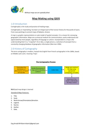
  • 1. Without maps we are spatially blind Eng Arnold M Kilaini-kilaini1@gmail.com Map Making using QGIS 1.0 Introduction Cartoghraphy is the study and practice of making maps. Cartoghraphy or mapmaking, has been an integral part of the human history for thousands of years. From cave paintings to ancient maps of Babylon, Greece. A map is a graphic representation or scale model of spatial concepts. It is a means for conveying geographic information. Maps are a universal medium for communication, easily understood and appreciated by most people, regardless of language or culture. Incorporated in a map is the understanding that it is a "snapshot" of an idea, a single picture, a selection of concepts from a constantly changing database of geographic information (Merriam 1996). 2.0 History of Cartography The term cartography is modern, loaned into English from French cartographie in the 1840s, based on Middle Latin carta meaning "map". N.B:Good map design is learned Standard Map Features. 1. Title 2. Scale 3. North Arrow/Orientation/direction. 4. Legend. 5. Source. 6. Author. 7. Date.
  • 2. Without maps we are spatially blind Eng Arnold M Kilaini-kilaini1@gmail.com 3.0 The Map making in QGIS For Creation of Map there should be spatial data in the map canvas already Click on Project>>>New Print Composer for Beginning on map composing. Click on “OK”
  • 3. Without maps we are spatially blind Eng Arnold M Kilaini-kilaini1@gmail.com The Menu Bar consists of File,Edit,View,Layout,atlas and Settings. To Add the Panels if there are missing You Click VIEW>>>Panels>>>Then Tick composition,item Properties,command Histroy,Atlas Generation and Items. N.B If they are cheked there is no need of checking. Below are the tools for working on during Map compostion or preparation of thematic map Icon Pupose Icon Pupose This is Used to Add new Map.This reflects from what is kept on Map Canvas This zooms the Map.
  • 4. Without maps we are spatially blind Eng Arnold M Kilaini-kilaini1@gmail.com Pan Composer.It enables you to pan your map This is typically for Texting label normally termed as Add New Label. i.e Writting text data in your map frame. This is known as Add new Legend.This adds the Legend or Key as in the layer panel. This is used to Add New Scale bar.It shows the Scale Bar This Selects or Move item with relation to the Map frame. Move Item Content.This moves the item contents within the map. Add Arrow.This Adds the North Arrow,we all know that direction is also the vital point in cartography. Adds Image.This adds image/ Picture Adds Shape.It can add either Triangle,Rectangle or Elipse It Adds Nodes. Exports the Map as Image,SVG and Pdf respectively This Adds Attribute table. Zooms in and Zooms out icons respectively. Printing tool. They can be found on Layout or Side Tool bars as shown below: Add new Map then use Move item Content to positon the map correctly in it’s data frame.
  • 5. Without maps we are spatially blind Eng Arnold M Kilaini-kilaini1@gmail.com Click the Add new Label/ Text Label for writting the Text data as in the “Title” or Data Source” or “Author” Add the Arrow for Direction by pointing from downwards to the top, for North direction.
  • 6. Without maps we are spatially blind Eng Arnold M Kilaini-kilaini1@gmail.com Add Scale Add Legend or Key Legend can be adjusted if the Key has alot of values for good presentation of the map.
  • 7. Without maps we are spatially blind Eng Arnold M Kilaini-kilaini1@gmail.com Add Photo or picture for wheather a National Logo,Council Logo or Company Logo
  • 8. Without maps we are spatially blind Eng Arnold M Kilaini-kilaini1@gmail.com You can add background as in trying to beautify a map but it all depends with the audience Adding Frame and Grids in the map as in Grids will eventually account with the Coordinates as per cartography principles. Note:It is activated after clicking (Select/Move item) the Map frame
  • 9. Without maps we are spatially blind Eng Arnold M Kilaini-kilaini1@gmail.com Adjusting the intervals of X and Y to get the appropriate grid scale and Drawing cooridinates for better presentation
  • 10. Without maps we are spatially blind Eng Arnold M Kilaini-kilaini1@gmail.com
  • 11. Without maps we are spatially blind Eng Arnold M Kilaini-kilaini1@gmail.com Now we have finished with the Thematic Map Making we can now either Export the map as Image,SVG or PDF. We are done now you can share your beautiful map to ypour intended audience but, Note that: The beauty of the map depends on the cartoghrapher as long as you follow the cartographic principles.
  • 12. Without maps we are spatially blind Eng Arnold M Kilaini-kilaini1@gmail.com 4.0 References Merriam, D.F. 1996. Kansas 19th century geologic maps. Kansas Academy of Science, Transactions 99, p. 95-114. UWFGISMOOC-MapDesign History of Cartography-Wikipedia THE END