
Recommandé
Recommandé
Contenu connexe
Tendances
Tendances (20)
En vedette
En vedette (10)
Similaire à Historical geology field assignment
Similaire à Historical geology field assignment (20)
Dernier
Dernier (20)
Historical geology field assignment
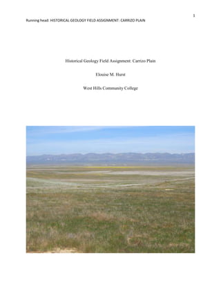
- 1. Historical Geology Field Assignment: Carrizo Plain<br />Elouise M. Hurst<br />West Hills Community College<br />Abstract<br />For the Historical Geology Field Assignement, I visited the Carrizo Plain National Monument in San Luis Obispo County, California. The five subjects I picked were the overall history of the Carrizo Plain, Soda Lake, saltbush plants, barn owls and the San Andreas Fault.<br />Historical Geology Field Assignment: Carrizo Plain<br />The Carrizo Plain National Monument, located approximately 100 miles north of Los Angeles, encompasses 250,000 acres of grassland valley. On its eastern side it is bordered by the Temblor Range and by the Caliente Range on its western side. The San Andreas Fault runs the length of the eastern margin; along the western edge of the Temblor Range (Figure 1). Soda Lake, a 3,000 acre seasonal alkali lake, lies in the northern portion of the plain. <br />This area was originally a shallow to intermediate depth marine basin which was uplifted during the Pleistocene. Marine sedimentary rock, both non-organic and organic, is the predominate rock of both the Temblor and Caliente Ranges (Geology, 1999).<br />Figure SEQ Figure ARABIC 1: Soda Lake with Temblor Range<br />552450311594500The entire Carrizo Plain area drains internally (Hildinger, 1995). The water from the western slopes of the Temblor Range and the eastern slopes of the Caliente Range all drain into the Carrizo Plain. This water collects on the valley floor and creates Soda Lake and many other small pools and ponds. Soda Lake (Figure 2) is not the remnant of a large ice age lake but was formed due to uplift associated with the San Andreas Fault. Between 3-1 million years ago the river formed from the runoff flowed southward out of the valley. Uplift to the south caused the river to change direction and flow northward. Uplift to the north then blocked the river and led to the formation of Soda Lake.<br />Figure 2: Soda Lake<br />During the late summer months or earlier in years of low precipitation, Soda Lake dries up. The crust (Figure 3) left behind is a mixture of salts; 82% sodium sulfate, 9% sodium chloride and 9% miscellaneous salts (Hildinger, 1995). The salts have accumulated from erosion of the surrounding mountains that were transported by runoff and evaporated on the valley floor.<br />Figure SEQ Figure ARABIC 2: Salt Crust<br />Figure 4: Saltbush<br />Saltbush (Figure 4) is a native plant of California and is found only from San Luis Obispo to Fresno, CA (Wilson, 2011). It is found lining the shores of Soda Lake and other low-lying areas on the Carrizo Plain where water collects in the spring. <br />This species, Atriplex spinifera, has evolved to thrive under harsh conditions. It does best under water-stress conditions such as drought and salt. Under extreme drought conditions it will shed its leaves. Saltbush removes the salt from the water and stores it in bladders located in its leaves (Wilson, 2011). When the leaves are shed or are eaten by animals, the salt is then removed from the plant. <br />Figure 5: Barn Owl<br />Figures 5 and 6 are photographs of Barn Owls. The Barn Owl (Tyto alba) is found on every continent except Antarctica. It is the most wide spread of all owl species and very adaptive to many environments. They prefer primarily open lowlands with some trees like farmland and semi-arid shrub lands but are also found in various forest types and urban areas (Behrman, 2011).<br />The fossil record of the barn-owl goes back to the Eocene and then showing a decline in the Neogene. The first time the barn owl was official described was in 1769 by Giovanni Scopoli, an Italian naturalist. There are currently 16 known species of barn owl in the world. <br />The Barn Owl has adapted to feed on a wide variety of food sources. While the Barn Owl feeds mostly on small mammals such as mice, voles, squirrels and skunks, they have also been documented to feed on lizards, fish, birds and insects.<br />Certain areas such as Connecticut have seen a decline in Barn Owl populations. This is due to loss of foraging and nesting habitat and the increased use of rodent poison which has reduced the owls’ food base. Currently the Barn Owl is listed as an endangered species in the state of Connecticut (Connecticut, 2011).<br />Figure 6: Barn Owl<br />Figure 7: Wallace Creek Offset<br />The San Andreas Fault is the longest fault in California; measuring nearly 800 miles. The fault runs along the western edge of the Carrizo Plain along the lower portion of the Temblor Range. The San Andreas Fault was formed during the Cenozoic Era by the collision of the Pacific plate with the North American plate (Levin, 2010). Instead of the Pacific plate being sub ducted under the North American plate, it started a lateral or strike-slip motion. The land mass west of the fault is moving in a generally northward direction at about 2 inches per year (Schulz, 1997). This rate is not fixed along the entire length of the fault as some sections slowly creep each year while others lay dormant for long periods of time and move with earthquakes. Geologists believe that since the formation of the San Andreas Fault 15-20 million years ago, the total movement of the fault is 350 miles (Schulz, 1997).<br />Figure 7 shows the offset caused by the San Andreas Fault. Wallace Creek flows across the fault and its path has been altered by the plate movement. During runoff, the water flows from right to left in the picture. In the last 3,800 years, Wallace Creek has been offset approximately 420 feet by the San Andreas Fault.<br />References<br />Behrman, L. (2011). Barn Owl. Retrieved from http://www.peregrinefund.org/explore_raptors/owls/barnowl.html<br />Carrizo Plain National Monument. (2011, April 25). Retrieved from http://www.blm.gov/ca/st/en/fo/bakersfield/Programs/carrizo.html<br />Connecticut Department of Environmental Protection. (2011). Barn Owl. Retrieved from http://www.ct.gov/dep/cwp/view.asp?q=325962 <br />Geology and Paleontology. (1999). Retrieved from http://www.blm.gov/pgdata/etc/medialib//blm/ca/pdf/pdfs/bakersfield_pdfs/bake_cpnaplan.Par.4e448b5d.File.pdf/GeologyPaleontology.pdf<br />Hildinger, J. (1995). Carrizo Plain Natural Area. Retrieved from http://www.scec.org/wallacecreek/guides/blm-cpna.pdf<br />Levin, H. (2010). The Earth Through Time. Hoboken, NJ: John Wiley & Sons, Inc.<br />Schulz, S. (1997, June 24). The San Andreas Fault. Retrieved from http://pubs.usgs.gov/gip/earthq3/safaultgip.html<br />Wilson, B. (2011). Atriplex spinifera. Retrieved from http://www.laspilitas.com/nature-of-california/plants/atriplex-spinifera<br />