Green Ike
•
1 j'aime•578 vues

as presented on April 17, 2009 at Gulf Coast Green - www.gulfcoastgreen.org

Recommandé
Contenu connexe
Tendances
Tendances (20)
En vedette
Similaire à Green Ike
Similaire à Green Ike (20)
Plus de Hayley Pallister
Plus de Hayley Pallister (20)
Dernier
Dernier (20)
Green Ike
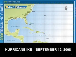
- 1. HURRICANE IKE – SEPTEMBER 12, 2008
- 6. Sept 12 on at 22nd & Strand Sept 12 at 22nd & Strand
- 8. Hurricane Ike Chinese FY1-D MVISR September 12, 2008 at 6:18 PM CDT
- 9. Storm Surge Captured by Spaceborne Radar Canadian RADARSAT 2 September 12, 2008, at 7:39:14 PM CDT Synthetic aperture radar data processed by the UT Center for Space Research Storm Surge in Progress
- 10. Synthetic aperture radar data processed by the UT Center for Space Research Storm Surge Captured by Spaceborne Radar European ESA ENVISAT ASAR September 12, 2008, at 11:23:04 PM CDT Ike Storm Surge in Progress
- 11. Storm Surge Captured by Spaceborne Radar Canadian RADARSAT 2 September 13, 2008, at 7:10:06 PM CDT Synthetic aperture radar data processed by the UT Center for Space Research Residual Storm Surge
- 32. F GALVESTON ISLAND GULF OF MEXICO West Bay San Luis Pass Development as of 2000
- 41. I CRITICAL INFRASTRUCTURE AND DEVELOPMENT THE HOUSTON GALVESTON AREA
- 42. SURGE SIMULATION Hurricane Carla September 5-11, 1961 A large, slow-moving storm that made landfall near Port Lavaca Sustained winds of 150 mph (Category 4) Peak wind gusts of 175 mph Storm surge of 22 feet (Matagorda Bay) 18.5 feet (Port Lavaca), 14.5 feet (Port O’Connor), 14.8 feet (Houston Ship Channel) Rainfall of 16.49 inches (Galveston), 6.25 inches (Victoria), 5.15 inches (Corpus Christi) 34 Deaths in Texas $400,000,000 of storm damage (1961 dollars) MODELING PREPARED BY U.T. CENTER FOR SPACE RESEARCH
- 43. Hurricane Carly Houston-Galveston Study Area Landfall
- 44. Hurricane Ike Chinese FY1-D MVISR September 12, 2008 at 6:18 PM CDT
- 45. Houston-Galveston Study Area Mean Sea Level HOUSTON Texas City Galveston La Porte League City Alvin Baytown JSC
- 46. HOUSTON Texas City Galveston La Porte League City Alvin Hurricane Carly 4/22 at 0800 CDT MEOW NW at 8 MPH Surge: 4.8 Feet Baytown JSC
- 47. HOUSTON Texas City Galveston La Porte League City Alvin Hurricane Carly 4/22 at 1200 CDT MEOW NW at 8 MPH Surge: 10.6 Feet Baytown JSC
- 48. HOUSTON Texas City Galveston La Porte League City Alvin Hurricane Carly 4/22 at 1700 CDT MEOW NW at 8 MPH Surge: 17.9 Feet Baytown JSC
- 49. HOUSTON Texas City Galveston La Porte League City Alvin Hurricane Carly 4/22 at 2000 CDT MEOW NW at 8 MPH Surge: 22.4 Feet Baytown JSC
- 50. Houston-Galveston Study Area Mean Sea Level HOUSTON La Porte Pasadena Baytown Webster Bacliff Deer Park JSC
- 51. Hurricane Carly 4/22 at 0800 CDT MEOW NW at 8 MPH Surge: 4.8 Feet HOUSTON La Porte Pasadena Baytown Webster Bacliff Deer Park JSC
- 52. Hurricane Carly 4/22 at 1200 CDT MEOW NW at 8 MPH Surge: 10.6 Feet HOUSTON La Porte Pasadena Baytown Webster Bacliff Deer Park JSC
- 53. Hurricane Carly 4/22 at 1700 CDT MEOW NW at 8 MPH Surge: 17.9 Feet HOUSTON La Porte Pasadena Baytown Webster Bacliff Deer Park JSC
- 54. Hurricane Carly 4/22 at 2000 CDT MEOW NW at 8 MPH Surge: 22.4 Feet HOUSTON La Porte Pasadena Baytown Webster Bacliff Deer Park JSC
- 55. Estimated Total Wind Damage from Hurricane Carly Hurricane Carly Houston-Galveston Study Area Landfall Counties Affected: 31 Population Affected: 5,425,334 Households Affected: 1,913,906 Residences Destroyed: 119,626 Debris Generated: 124,023,000 tons Damage Amount: $73,612,335,000
- 62. EVACUATION ZONE POPULATION PROJECTIONS ZONE 2005 2020 2035 A 104,159 131,129 166,144 B 297,467 384,850 474,065 C 622,292 747,933 921,388
- 64. Hazardous Waste
- 65. Landfills - (White) Closed / (Grey) Open
- 67. Outfalls – Municipal/Commercial (Green)
- 68. FLOOD PLAINS AND CRITICAL FACILITIES
- 70. Hurricane Carly 4/22 at 2000 CDT MEOW NW at 8 MPH Surge: 22.4 Feet HOUSTON La Porte Pasadena Baytown Webster Bacliff Deer Park JSC
- 72. Galveston Flooding Behind Seawall 4 ft rise in Galveston Bay
- 73. FUTURE OF U.S. 87?
- 74. FUTURE OF U.S. 87?
- 76. THE IKE DIKE
- 77. Bolivar Roads
- 78. Maeslant Barrier
- 79. Animation of the closing of a Maeslant Barrier
- 80. When the gates have closed, the barrier drops down
- 81. San Luis Pass
- 85. EXPAND NATIONAL WILDLIFE REFUGES
- 87. New Haz Waste and Storage Regulations Best Land Management Regulations and $ Expanded Wildlife Refuges Bolivar National Seashore and $ Strict Development Regulations Conceptual Future $
- 88. THANK YOU