Innovation transforms livelihoods of pastoralists in Ethiopia
•
0 j'aime•215 vues

Until the 1970s, traditional pastoralism used to be a successful livelihood strategy in drought-prone East African lowlands, where the rainfall regime is low and unreliable, and where mobility was essential for ensuring access to critical water and feed resources. It also provided space for the rangeland to regenerate. However, the traditional livelihood strategy has been increasingly constrained.

Recommandé
Contenu connexe
Tendances
Tendances (20)
Similaire à Innovation transforms livelihoods of pastoralists in Ethiopia
Similaire à Innovation transforms livelihoods of pastoralists in Ethiopia (20)
Plus de ICRISAT
Plus de ICRISAT (20)
Dernier
Dernier (20)
Innovation transforms livelihoods of pastoralists in Ethiopia
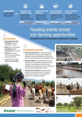
- 1. Innovation transforms livelihoods of pastoralists in Ethiopia QUICK IMPACT of pilot project in Afar region* Productive oasis created in 3 years: Harnessed flood water re-greens degraded rangelands Increased food self sufficiency: Growing food and forage led to less reliance on food aid More sustainable pastoral systems: Increased feed and water access around the year Proven potential for scaling up: Set for replication in entire Afar, Somali region and Omo-Gibe basin THE CHALLENGE Flooding events turned into farming opportunities AN INNOVATIVE SOLUTION • Water Spreading Weirs: To capture and spread the torrential flood emerging in the neighboring highlands to low-lying rangelands and crop fields, five weirs were built based on land suitability studies. • Working together: Joint planning and execution between community leaders, landscape and crop researchers and development agents using a combination of good agronomy, remote sensing and GIS-based maps yielded positive results. • Success draws attention: Seeing the results, pastoralists were willing to take up farming. It created local confidence, drew government attention and benefited pastoralists. Water Spreading Weirs 2015 Run-off from highland floods Pastoralists learn farming Growing food-feed crops •• Land degradation robs livelihoods of lowland pastoralists in Chifra. •• Floods from the highlands, dwindling rains and overgrazing make it worse. •• Conflicts over scarce resources and dependence on food aid increase. •• Urgent need for creating options for pastoralists. 3.5 M ha can benefit from this technology 10-12 t/ha biomass produced 8 food-feed crops introduced 46 ha of unproductive land turned to farms Implemented by 2018
- 2. 2 3 Magnitude of recurrent floods and droughts in Eastern and Southern Africa The major victims of recurrent drought and flood are predominantly pastoral and agropastoral communities, inhabiting low-lying downstream areas. Impact of drought Low-lying plains in East Africa receive limited and unreliable rainfall. The impact of drought has been already felt in the last three decades. The effect is aggravated by degradation of rangelands and limited capacity of pastoralists to respond to these extreme events. As recent as in 2016-2017, millions of people were under extreme risk of food deficit due to drought in Eastern and Southern Africa. Major countries affected include: • Kenya • South Sudan • Malawi • Zimbabwe • Ethiopia • Somalia Zambia, Malawi and Mozambique The 2019 flood has affected >260,000 people across the three countries. (The Guardian 19 March 2019). Recurrent floods in the Zambezi river have affected humans and livestock through drowning and landslides, reduction in crop production, displacement of people, and damage of assets and infrastructure. Impact of floods Factors that compelled communities to turn to agropastoral systems Ethiopia Kenya Impact of climate change: Disappearing seasons in Afar •• Kermawhichistheprimaryrainyseason,historically spanned four months from mid-June through mid- September. It is now limited to the month of mid- July and August. •• Dedaa which occurred as occasional rainfall in mid- December has disappeared. •• Segum which occurred in March and April as a minor rainy season has disappeared entirely. “What’s left is only the names of the seasons.” Ahmed Wogris, Lead agropastoralist Floods erode livelihoods regularly by: •• Destroying household assets •• Eroding fertile soils •• Creating large gullies •• Destroying farming and grazing lands. These extreme events are expected to get worse due to climate change and variability (Gummadi et al. 2017). 300,000 people, mainly in the regions of Gambella, Afar and Oromia were affected by flood in 2017 (UNICEF, 20 Sep 2017). >500,000 people are at risk of flooding on yearly basis as extreme events are expected to continue (GoE, 2018). >300,000 people were forced to flee and at least 186 people died due to incessant heavy rainfall in 2018. The rain caused overflow of dams and rivers, submerging crops and washing away homes (Reuters 4 July 2018). Providing alternatives for pastoralists seeking new livelihood options Until the 1970s, traditional pastoralism used to be a successful livelihood strategy in drought-prone East African lowlands, where the rainfall regime is low and unreliable, and where mobility was essential for ensuring access to critical water and feed resources. It also provided space for the rangeland to regenerate. However, the traditional livelihood strategy has been increasingly constrained by: •• Decreasing productivity of rangelands to supply required grazing and watering points; •• Local conflicts due to competition for vital resources; •• Increasing pressure on communal land by foreign agricultural investments; •• Increasingly sealed regional and country borders due to political tensions; •• Rangeland degradation resulting in negative impacts on the ecosystems, livestock production and livelihoods; •• Climate and market risks; •• Low resource base of the dry lowlands requires substantial time to provide ecological and economical services. Over the years, pastoralists have adopted and changed many management strategies: •• Burning and mobility were twin strategies, though burning is no more practiced. •• Participatory area enclosure, reseeding and fertilizer application was used to rehabilitate degraded rangelands. However, poor coordination between stakeholders servicing rangelands impaired progress. •• Water scarcity remained a major challenge, overriding all the other rangeland investments. Constraints of spate irrigation systems in use: •• High maintenance requirement, particularly in low-lying flat areas receiving floods with high intensity and high sediment load, especially of coarse material; •• High labor demand, particularly in peak seasons; •• Unpredictability of the runoff for downstream users; •• Destruction of farms and rangelands due to uneven flow and distribution; •• Frequent loss of top soils due to high flood; •• Agropastoral communities rarely benefit from spate irrigation due to their mobility. In the given scenario, the need for new rainwater management systems was strongly recognized Capacity building of pastoralists: Classroom and field training in agronomy and farm operations was given to willing and lead pastoralists. The challenge summary See page 6
- 3. Greening degraded rangelands using the Innovation System approach: Pilot project at Shekayboru kebele in Chifra woreda of the Afar region The big shift to agropastoralism OUTCOME Success of lead agropastoralists encourages others to shift to the new system Monitoring & Evaluation Learnings are ploughed back into project and upscaling endeavors AGRI-SCIENCE Cropping zones mapped based on soil moisture content and capacity building of pastoralists (ICRISAT & Agri-universities) INNOVATIVE TECHNOLOGY Water Spreading Weirs capture highland floods and spread to lowlands (Designed by GIZ-SDR) SOCIAL DYNAMICS Community chiefs (Kedoh Abbobti) coin byelaws, fine crop-grazing and facilitate the shift EXTENSION SYSTEM Pastoral Agriculture and Development Office (PADO) acts as law enforcer, community mobilizer and conflict mediator Future steps Flood analysis of Afar region shows flood-based farming potential: Pilot to be upscaled in Shebelle and Genalle basins in Somali region and Omo-Gibe basin *Amhara Regional Agricultural Research Institute 550,000 ha 1.2 million ha in Belg (Short rains) in Meher (Main rainy season) Impact of Water Spreading Weirs • Soil moisture is raised • Soil loss is arrested • Flood velocity reduced • Excess flood is drained SOCIAL IMPACT Social benefits Construction of schools and health post were taken up by the local administration as communities settled. Empowerment Local leaders were recognized and they participated in local administration meetings. Women play a greater role in farming. Influence on policy The success of the pilot project led to government interest in replicating it in the Afar region and beyond. Government cabinet ministers visited the project site more than once. Upscaling technologies Bureau of Pastoral Agriculture and Development is expected to take up the oversight and outscale to multiple communities. FARMING IMPACT Sorghum, maize, mungbean, cowpea and teff were grown in 24 ha 5 t/ha Maize yield 10 t/ha Biomass 2016 12 t/ha 2 t/ha 52 Elephant grass biomass Mung bean yield households take up farming Farming area expands to 46 ha. Elephant grass, pigeonpea and lablab crops introduced 2017 Mango seedlings were planted Capacity building outcome: Agropastoralists learn to gauge soil moisture and take their own cropping decisions. 2018 Law-abiding pastoralists Only 8 cases of penalty were reported in one year – unprecedented in a pastoral community! The byelaw stipulated that if fenced crop and fodder is damaged by animals, the owner of the animal would be fined 100, 200 and 300 birr per animal in the first, second and third incidences, respectively. Recurrent law breakers were referred to PADO for stronger action. ICRISAT prepared the GIS maps for the period 2015 -2018 for entire Afar region using Sentinel satellite data. Flood water analysis Afar region in Ethiopia Shekayboru kebele Crop systems for each moisture zone: ICRISAT, Wollo University, Woldya University and ARARI* developed a system to identify, prioritize and integrate best-bet agricultural practices and crops. MAZ: Maize EGR: Elephant grass NaGR: Napier grass NGR: Natural grass BLD: Bushland PAR: Parthenium weed CAT: Sedimented area FLD: Fallow land Weirs River Community road Gulley Waterway SOR: Sorghum TEF: Tef MUB: Mung bean CPE: Cowpea PPE: Pigeonpea SES: Sesame Chifra woreda 4 5
- 4. An alternate method of flood management using Water Spreading Weirs Technical innovations for adaptive management of flood-based land restoration Case study of pilot project at Shekayboru kebele in Chifra woreda of the Afar region Land Chifra district is located in Zone 1 of Afar regional state of Ethiopia near the base of the eastern escarpment of the Ethiopian highlands. People • Semi-settled pastoralists • Heavily relied on food aid School enrolment 27-32% Literacy > 85% are illiterate Climate Crop allocation based on moisture regime High moisture: Maize and sorghum Low moisture: Early-maturing legumes/grasses 2016: Local varieties of maize and sorghum were grown but they failed due to short flooding seasons. Construction of Water Spreading Weirs: Inspired by the ancient Nabataan system GIZ-SDR built five cascaded weirs with an average distance of 50 to 180 mts from each other, depending on contour, flood intensity and sediment load. The weirs were built in the foot slopes of Tehuledere mountains of the Amhara region in 2014-2015 to regulate seasonal floodwaters, reduce runoff and minimize erosion. Design of the weirs: •• Made of natural stone and cement •• Consist of a spillway in the dry riverbed •• Lateral abutments for stabilization •• Wing walls span the width of the valley. Given the high rainfall (950 mm per year) at Tehuldere and shallow soils, it produces seasonal high intensity flash floods. The run-off was collected from a large area of these watersheds and directed to flat plains in the lowlands. The weir ensures that soil moisture increased and soil loss arrested while making provision for draining excess water. GIS-based farm-level land suitability map Measuring soil moisture variability: The flow path and intensity of water spreading in the plain (above and below the weir) is controlled by the in-situ microrelief, slope, height difference between the valley and plain surface, and flood volume. These landscape characteristics contributed to varied soil moisture regimes, flow direction and intensity above and below the structures, which created huge soil variability. Recurrent measurements were made using soil moisture sensor (TDR-300, Spectrum technologies) at a soil depth of 0-20 cm and 21 to 40 cm in multiple directions from the weirs. The entire field was tracked using GPS in order to locate plots with similar soil moisture regime and soil nutrient levels, which was used to classify the landscape into different land-use categories. A GIS-based solution guide was designed to guide extension workers and farmers to target their farm plots with differing management options. Changing land quality due to floods The flood emerging from the highlands carry significant load of soil and sediment to downstream sinks. The sediment-laden flood create differing land quality within the landscape. The different land parcels which had significantly different crop performance and yield were grouped into at least four crop management zones depending on the water holding capacity of the soil, soil texture and crop performance. (see below) Zone 1: This parcel was located immediately above the weir (B & E), where flood velocity is very high and sediment load is highest. In this zone, crop and fodder choices were highly limited by waterlogging after floods and sediment loads afterwards. Zone 4: These areas (F) had a concentrated flow with high speed and volumes, extended submerged conditions as well as abrasive forces to sensitive species. Any crop or forage planted in this parcel could be washed away. 2017: Early-maturing, drought-resistant varieties of maize (Melkassa-4 and Melkassa 2) and sorghum (Girana) along with drought-resistant legumes, mainly mung bean and pigeonpea and drought-resistant forage grasses were grown with very good results. The area has as arid and semi-arid climate with low and erratic rainfall and high temperature. Extreme weather patterns like drought and intermittent dry spells are common. Project site (yearly average) Rainfall: 200-500mm Neighboring Amhara highlands: Receive about 1,000 mm rainfall in just two and half months’ time. Short rains (belg): March-April Long rains (meher): July-August Temperatures: 28-40°C Zone 3: These farms are located on the outskirts of the weirs (G) on patches with higher slope and in areas where the weir limited natural overflow of water (C). They received flood during high flows and rain showers. The zones were mostly well-drained, shallow and suitable only for drought-resistant and early-maturing crops as well as grasses. This zone covered the largest area with a potential of increasing in size in the future. This zone also requires improved flood management along with water-saving technologies and practices. Zone 2: It is predominantly a wet-zone (D & A). moistened mainly through flood reversal and subsurface lateral flows. A similar parcel of this category was located immediately below the WSW structures, which receive steady floods where the flow intensity is slowed down and spread by the structures. This part of the farm was found to be highly suitable for agricultural production. 6 7
- 5. ! !! ! ! !!! ! ! !!! ! !!! !! ! ! !! !! ! !!! !! !! ! !!! !! ! !! ! !!! ! ! !!! !! !! ! !! !!! ! !!!! ! !!! !! !!! !!! ! !!!! ! !! !!!! !!! !!! !!! ! !!! !! ! !! !!! ! !! ! !!! !!! ! !! !! !! ! ! !! !!!! !! !!! ! ! ! !!!! !!! ! ! !! !!! !!! !! ! !! !!!! !!! ! ! !! !!! !! !!!! !! !! !! ! ! ! !! ! ! !!! !! !! ! ! ! !! !!! ! !! !!! ! !! ! ! !! !! !!! ! ! !!! !! ! ! !! ! ! ! !!! ! !! !! !! !! ! ! !!! !!! !! !! !! !! !! ! ! !!!! !!! !! ! !!!! !! !! !! !!! !! !! !! !! !!!! ! !! !!! !! !!! !!! ! !! !! ! ! ! !!!!! !! !!!! !! !!! ! !! ! !! !! !!!!! !! !! ! !! ! !!! ! !!! !! ! ! !! !! !!!! ! !! !! !!! !!!!! ! !! ! !! ! !!! !! !!!! !! !!! ! !! !! !! ! ! ! ! ! ! ! ! ! 1 6 3 11 22 9 2 4 20 8 26 18 12 7 16 10 21 19 5 13 24 28 25 15 17 29 23 27 14 Conceptualization and editing: Jemima Mandapati Design: Meeravali SK; Strategic Marketing & Communication, ICRISAT Photos: GIZ/ICRISAT Contact: Dr Tilahun Amede (t.amede@cgiar.org) Address: ICRISAT-Ethiopia; (c/o ILRI) PO. Box 5689, Addis Ababa Scaling up technologies in other areas of Afar Yallo district: Three successive weirs were built in Yallo district, Wokriede kebele in Northern Afar in 2016 and 2017. Agricultural operations started in the main season of 2018. In Wokriede, excessive runoff was collected from drought-prone nearby local hills as it does not neighbor with highlands. There was no experience in agriculture (growing of food and feed crops) in the locality before the arrival of this project. It is inaccessible and far away from market opportunities. Ewa district: Three weirs were also built in Ewa district and agricultural operations started in the main season of 2018. All the crops grown in the Chifra project site are grown in these two regions. Flood analysis for entire Afar region was done from July- August (2015-18) using Sentinel-1 satellite data. The potential area for flood-based farming during belg and meher seasons was 550,000 and 1.2 million ha, respectively. Interventions in this area could make Afar food secure and reduce its vulnerability significantly. Opportunities in Somali and Omo-Gibe regions Geo-spatial products from ICRISAT to support similar initiatives include: •• Crop type/intensity maps •• Length of growing periods •• Spatial modeling (prioritization) •• Simulated yield estimations and impact •• Tracking adoption of NRM technologies •• Land-use changes •• Abiotic stresses •• Impact assessment Citation: Tilahun Amede, Elisabeth Van den Akker, Wolf Berdel, Christina Ketter, Gebeyaw Tilahun, Asmare Dejen, Gizachew Legesse, Hunegnaw Abebe and Mezgebu Getnet. 2019. Flooding events turned into farming opportunities: Innovation transforms livelihoods of pastoralists in Ethiopia. Policy Brief 13, ICRISAT. * Reference: Amede et al. 2019. Facilitating negotiated transformation from pastoral to sustainable agropastoral systems through flood-based land restoration in drought-prone regions of Afar, Ethiopia (under review). Dr Elisabeth Van den Akker GIZ SDR, elisabeth.akker-van@giz.de Funder and partner: Partners: This work was undertaken as part of the CRP Implemented by Teff Mung beanPigeonpea