SlideShare une entreprise Scribd logo
1  sur  4
Télécharger pour lire hors ligne
IJRET: International Journal of Research in Engineering and TechnologyISSN: 2319-1163
__________________________________________________________________________________________
Volume: 02 Issue: 05 | May-2013, Available @ http://www.ijret.org 783
A NOVEL APPROACH FOR GEOREFERENCED DATA ANALYSIS
USING HARD CLUSTERING ALGORITHM
Y.Sophiya Banu1
, Y.Soniya Banu2
, V.V. Karthikeyan3
1, 3
SNS College of Engineering, Coimbatore.,2
PSG College of Technology,Coimbatore
sophiyabanu05@gmail.com, soniyayusuffsai@gmail.com, karthi_maharaja@yahoo.com
Abstract
The process of defining its existence in physical space is called as Georeferenceing.That is establishing its terms of projections or
coordinate systems.When data from different sources need to be combined and then used in a GIS application.In this work
georeferenced data on soil map is clustered using a soft clustering algorithm. Most georeferencing tasks are undertaken to generate
new map. Thus a map generated using GIS software is clustered for data analysis of soil type and vegetation possibilities.Remotely
sensed data plays an important role in data collection,the platforms usually consist of aircraft and satellites.GIS is attached to many
operations and has many applications related to engineering, planning, management, telecommunications and business.
Keywords: Soil map, K-Means Clustering Algorithm,Geographic Information System.
------------------------------------------------------------------***------------------------------------------------------------------------
1. INTRODUCTION
A Geographic Information System (GIS) is a system designed
to capture, store,manage,manipulate,analyze,and present all
types of geographical data in a digital formatGreene et.al has
given a detailed description. GIS is merging of cartography
and computer science technologyHeywood et.al (2006) has
denoted its applications.GIS and location intelligence
applications can be the foundation for many location-enabled
services that rely on analysis and dissemination of results for
collaborative decision making.Remotely sensed data also
plays an important role in data collection. Itconsist of sensors
attached to a platformJ. Sun et.al (2010) has represented its
process and operation. Sensors include cameras, digital
scanners and LASER, while platforms usually consist of
aircraft and satellites. More advanced data processing can
occur with image processing techniques. It includes contrast
enhancement,falsecolor rendering and a variety of other
techniques including use of two dimensional Fourier
transforms.In this work spatial domain processing of the
georeferenced data analysis has been attempted.The satellite
data obtained by remote sensing is represented in Figure 2(a)
andGeoreferenced data are shown in Figure 2(b).The spatial
location of other geographical features is determined. The hard
clustering technique called K-means is adopted for the
clustering of the georeferenced data.
2 METHODOLOGY
The Flow chart of the proposed method of georeferenced data
analysis is shown in Figure 1. Preprocessing is considered as
very important task in the hard clustering analysis of
georeferenced data. Initially the image is converted intoa gray
scale image. In the second stage the image is resized to reduce
the computational complexity. At the third stage the image is
clustered into individual regions. The georeferenced image is
clustered into regions based on the flow chart shown in Figure
3.
FIGURE 1 Flow chart of Georeferenced data clustering
READ A GEOREFERENCED
IMAGE
IMAGE RESIZE
HARD CLUSTERING
START
RGB TO GRAY CONVERSION
STOP
IJRET: International Journal of Research in Engineering and TechnologyISSN: 2319-1163
__________________________________________________________________________________________
Volume: 02 Issue: 05 | May-2013, Available @ http://www.ijret.org 784
(a) (b)
FIGURE 2 (a) Satellite image (b) Georeferenced data
2.1 GeoreferncedData
Cartography isa branch of science that deals with the design
and production of maps Calvertet.al (2013) has mentioned its
importance.It is the visual representation of spatial data. The
vast majority of modern cartography is done with the help of
computersPerry et.al (2006) has denoted a detailed procedure
of georeferencing. GIS based maps are best in quality but
production of quality cartography is also achieved by
importing layers.A design program to refine it is
appliedFonseca andEgenhofer (1999) has given a brief
introduction to soil maps. Most GIS software gives the user
friendly control over the appearance of the data.A map
produced using a GIS software is considered as the input to
the soft clustering analysis of georeferenced data analysis
process. A soil map is a visual representation of an area. Soil
map is a map that is a geographical representationSarma and
Jean-Paul Legros (2005) has denoted its developments. It
shows the diversity of soil types and soil properties in the area
of interest. It is typically the end result of a soil survey
investigations Chang, K. T (1989) has denoted its importance.
Soil maps are most commonly used for land evaluation.Spatial
planning, agricultural extension, environmental protection and
similar process can also be applications of soil map. In this
work the soil map is read as an input through the Matlab
command. Many maps are static two-dimensional,
geometrically accurate representation of three dimensional
spacesClarke K. C (1986) has given its process and
applications. Soil maps are typically richer in context and
show higher spatial details than the traditional soil maps.
2.2 Image Resize
Image resize is the second task of the process flow as depicted
by the Figure 1. The imresize command in matlab without
altering the pixel values it resizes the image and also computes
the number of rows or columns automatically to preserve the
image aspect ratioBentoutou et.al (2002) has given detailed
procedure. Hence the georeferenced Image is resized to (256 x
256).
2.3 RGB to Gray Conversion
There are several established color models used in computer
graphics, but the two most common are the RGB model (Red-
Green-Blue) for computer display and the CMYK model
(Cyan-Magenta-Yellow-Black) for printing Gonzalez and
Woods (2008) has presented a detailed view about digital
image processing. When red, green and blue light is combined
it forms white. Thus to reduce the computational complexity
the georeferenced data that exists in RGB color model is
converted intoa gray scale image.The range of gray scale
image from black to white values can be calculated by
equation (1). Where L is Luminance, R is RED, G is Green
and B is Blue.
L = 0. 2989 ∗ R + 0.5870 ∗ G + 0.1140 ∗ B (1)
2.4 Hard Clustering Simulation Results
K-Means Clustering algorithm is also called as Hard
clustering technique. Clustering based image segmentation is a
pixel by pixel segmentation method, and it stops the process of
clustering when the image is segmented into predefined
number of clusters. The flow chart of hard clustering
technique is denoted in the Figure 3. A cluster is therefore a
collection of objects which are “similar” between them and are
“dissimilar” to the objects belonging to other clusters J. Wood
(1996) has denoted its results. The segmentation results of
georeferenced data are shown in Figure 3. The input image is
preprocessed and clustered into individual regions Tianand
Guo (2011) has presented the advantages of clustering the soil
maps and georeferenced data. In this work georeferenced soil
map is taken as input is represented in Figure 2(b). The Hard
clustering technique is initiated with cluster value 5. In this
work Image segmentation is carried using K-Means Clustering
algorithm. K-Means is a method of clustering which allows
one piece of data to belong to two or more clusters. It is based
on minimization of the distance between the clusters.
Partitioning is carried out through an iterative optimization of
the mean distance between the cluster centers.
Segmentation is the process of partitioning a digital image into
multiple segments Choi et al (2011) has denoted the
segmentation process. The goal of segmentation is to simplify
and change the representation of an image into something that
is more meaningful and easier to analyze. In this project
clustering technique is used for image segmentation of
chromosomal images. The segmentation results are
represented in Figure 4. The region by region segmented
IJRET: International Journal of Research in Engineering and TechnologyISSN: 2319-1163
__________________________________________________________________________________________
Volume: 02 Issue: 05 | May-2013, Available @ http://www.ijret.org 785
image are denoted in Figure 4((a),(b),(c),(d)). Figure
4((e)and(f)) are the segmented results of FCM. The segmented
image is coded with specific color for understanding using
Matlab commands.
FIGURE 3 Flow chart of hard clustering
ALGORITHM
STEP 1: Initialize the K with 5 (K=1,……………….N).
STEP 2: Initialize cluster center 𝒄 𝒏(n=1…..K)
STEP 3: Data grouping based on defined K values.
STEP4: Reshaping the clustered data and display the
segmented image.
STEP 5: Determine the presence and absence of data
remaining.
STEP 6: Increment the K value for further segmentation if the
remaining dataexist. If else stop the process
(a) (a) (b)
(c) (d)
(e) (f)
Figure 4Simulation results (a) Gray scale image,
((b),(c),(d),(e),(f))Regions segmented
START
INITIALIZATION
START WITH K CENTERS
DISPLAY AS IMAGE
IF DATA
LOSS
NO
STOP
YES
INCREASE
K value
IJRET: International Journal of Research in Engineering and TechnologyISSN: 2319-1163
__________________________________________________________________________________________
Volume: 02 Issue: 05 | May-2013, Available @ http://www.ijret.org 786
3. CONCLUSION AND FUTURE WORK
Georeferenced data analysis is one of the important tasks in
the field of Geospatial Information Studies. It denotes the
academic discipline or career of working with geographical
information. During the analyzing process complex image
retrieved from the satellite is georeferenced using GIS
software. In the similar manner the soil map thus received
using a resource satellite is the input to this proposed method
of Hard clustering technique. A Hard clustering technique
which is the other name of the K- Means Clustering algorithm
has been attempted with a soil map image. The segmented
results produced by K- Means are denoted in Figure 4. When
the complexity of the image increases the efficiency in
computing decreases. The proposed method of georeferenced
data analysis uses a preprocessing stage before clustering.
Thus it reduces the segmentation error. Georeferenced data
which are read as an input has been segmented into region by
region. The pixel by pixel clustering for georeferenced data
analysis is an ideal method even in the case of a noisy image
because the input image can be denoised using any of the
spatial domain or frequency domain filters. It would be less
complex to analyze the possibility of vegetation and the types
of soil with the help of a soft clustering technique by a
Geoinformatics scholar when compared with the hard
clustering results represented in Figure 4((c) and (d)). The K-
Means clustering algorithm techniques has been evolving with
its adaptive nature. Hence if such Adaptive nature of K-
Means clustering algorithm is used it would produce even
better quality of segmented result. A comparative study is
possible with the emerging algorithms of clustering. Thus
when compared with the soft clustering segmented result
shown in Figure 4((e) and (f)) the K- Means segmented
results are needed to be improved for further analysis. Hence
for georeferenced data analysis process using clustering
technique the soft clustering technique based on Fuzzy
clustering is advantageous than the hard clustering technique.
REFERENCES
[1] Greene, R., Devillers, R. and Luther, J. "GIS-based
multi-criteria analysis". Geography Compass 5/6,
412–432.
[2] Heywood, I., Cornelius, S., & Carver, S. “ An
Introduction to Geographical Information Systems”,
Third Edition. Essex, England: Prentice Hall, 2006.
[3] K. Calvert, J. M. Pearce, W.E. Mabee, “Toward
renewable energy geo-information infrastructures:
Applications of GIScience and remote sensing that
can build institutional capacity” Renewable and
Sustainable Energy Reviews 18, pp. 416–429, 2013.
[4] Chang, K. T. "A comparison of techniques for
calculating gradient and aspect from a gridded
digital elevation model".International Journal of
Geographical Information Science 3 (4): 323–334,
1989.
[5] Chang, K. T. “Introduction to Geographical
Information Systems”. New York: McGraw Hill.
pp. 184, 2008.
[6] Fu, P., and J. Sun,” Web GIS: Principles and
Applications” ESRI Press. Redlands, CA, 2010.
[7] Clarke, K. C., “ Advances in geographic information
systems, computers, environment and urban
systems”, Vol. 10, pp. 175–184,1986.
[8] Sarma and Jean-Paul Legros, “Mapping of the
soil cover”, Enfield, NH, USA, Science
Publishers,2005.
[9] Cao H. and Wang Y. “Segmentation of M-FISH
images for improved classification of chromosomes
with an adaptive Fuzzy C-Means Clustering
Algorithm”. IEEE Transaction on Biomedical
Imaging ,20(1), 1442–1445,2011.
[10] Rafel C. Gonzalez , and Richard E. Woods.”Digital
Image Processing”. Pearson Education Third
ed.2008.
[11] Perry, Matthew, Hakimpour, Farshad, Sheth and
Amit,” Analyzing Theme, Space and Time”, proc.
ACM International Symposium on GIS.pp.147-
154,2006.
[12] Fonseca Frederico, and Egenhofer, "Ontology-
Driven Geographic Information Systems". Proc.
ACM International Symposium on Geographic
Information Systems. pp. 14–19,1999.
[13] Ma, Y., Guo, Y.,andTian, X., "Distributed
Clustering-Based Aggregation Algorithm for Spatial
Correlated Sensor Networks".IEEE Sensors
Journal 11 ,2011.
[14] J. Wood, “Invariant pattern recognition: A
review,”PatternRecognit., vol. 29, no. 1, pp. 1–17,
Jan. 1996.
[15] Y. Bentoutou, N. Taleb, M. C. E. Mezouar, M. Taleb,
and L. Jetto, “An invariant approach for image
registration in digital subtraction
angiography,”PatternRecognit., vol. 35, no. 12, pp.
2853–2865, 2002.
[16] B. Mahdian and S. Saic, “Detection of copy-move
forgery using a method based on blur moment
invariants,”Forensic Sci. Int., vol. 171, no. 2/3, pp.
180–189, Sep. 2007.
[17] V. Ojansivu and J. Heikkilä, “A method for blur and
similarity transform invariant object
recognition,”inProc. ICIAP, R. Cucchiara, Ed., 2007,
pp. 583–588.

Contenu connexe

Tendances

A New Method for Indoor-outdoor Image Classification Using Color Correlated T...
A New Method for Indoor-outdoor Image Classification Using Color Correlated T...A New Method for Indoor-outdoor Image Classification Using Color Correlated T...
A New Method for Indoor-outdoor Image Classification Using Color Correlated T...CSCJournals
 
Object-Oriented Image Processing Of An High Resolution Satellite Imagery With...
Object-Oriented Image Processing Of An High Resolution Satellite Imagery With...Object-Oriented Image Processing Of An High Resolution Satellite Imagery With...
Object-Oriented Image Processing Of An High Resolution Satellite Imagery With...CSCJournals
 
Estimation, Detection & Comparison of Soil Nutrients using Matlab
Estimation, Detection & Comparison of Soil Nutrients using MatlabEstimation, Detection & Comparison of Soil Nutrients using Matlab
Estimation, Detection & Comparison of Soil Nutrients using MatlabIRJET Journal
 
Performance of RGB and L Base Supervised Classification Technique Using Multi...
Performance of RGB and L Base Supervised Classification Technique Using Multi...Performance of RGB and L Base Supervised Classification Technique Using Multi...
Performance of RGB and L Base Supervised Classification Technique Using Multi...IJERA Editor
 
An enhanced difference pair mapping steganography method to improve embedding...
An enhanced difference pair mapping steganography method to improve embedding...An enhanced difference pair mapping steganography method to improve embedding...
An enhanced difference pair mapping steganography method to improve embedding...eSAT Publishing House
 
Application of Image Retrieval Techniques to Understand Evolving Weather
Application of Image Retrieval Techniques to Understand Evolving WeatherApplication of Image Retrieval Techniques to Understand Evolving Weather
Application of Image Retrieval Techniques to Understand Evolving Weatherijsrd.com
 
IRJET-A Review on Implementation of High Dimension Colour Transform in Domain...
IRJET-A Review on Implementation of High Dimension Colour Transform in Domain...IRJET-A Review on Implementation of High Dimension Colour Transform in Domain...
IRJET-A Review on Implementation of High Dimension Colour Transform in Domain...IRJET Journal
 
Brain tumor segmentation using asymmetry based histogram thresholding and k m...
Brain tumor segmentation using asymmetry based histogram thresholding and k m...Brain tumor segmentation using asymmetry based histogram thresholding and k m...
Brain tumor segmentation using asymmetry based histogram thresholding and k m...eSAT Publishing House
 
A modified pso based graph cut algorithm for the selection of optimal regular...
A modified pso based graph cut algorithm for the selection of optimal regular...A modified pso based graph cut algorithm for the selection of optimal regular...
A modified pso based graph cut algorithm for the selection of optimal regular...IAEME Publication
 
A GIS ANCHORED TECHNIQUE TO OBTAIN OPTIMAL PATH THROUGH MINIMAL ALTERATION OF...
A GIS ANCHORED TECHNIQUE TO OBTAIN OPTIMAL PATH THROUGH MINIMAL ALTERATION OF...A GIS ANCHORED TECHNIQUE TO OBTAIN OPTIMAL PATH THROUGH MINIMAL ALTERATION OF...
A GIS ANCHORED TECHNIQUE TO OBTAIN OPTIMAL PATH THROUGH MINIMAL ALTERATION OF...cscpconf
 
A gis anchored technique to obtain optimal path through minimal alteration of...
A gis anchored technique to obtain optimal path through minimal alteration of...A gis anchored technique to obtain optimal path through minimal alteration of...
A gis anchored technique to obtain optimal path through minimal alteration of...csandit
 
CONTRAST ENHANCEMENT TECHNIQUES USING HISTOGRAM EQUALIZATION METHODS ON COLOR...
CONTRAST ENHANCEMENT TECHNIQUES USING HISTOGRAM EQUALIZATION METHODS ON COLOR...CONTRAST ENHANCEMENT TECHNIQUES USING HISTOGRAM EQUALIZATION METHODS ON COLOR...
CONTRAST ENHANCEMENT TECHNIQUES USING HISTOGRAM EQUALIZATION METHODS ON COLOR...IJCSEA Journal
 
SEGMENTATION AND CLASSIFICATION OF POINT CLOUDS FROM DENSE AERIAL IMAGE MATCHING
SEGMENTATION AND CLASSIFICATION OF POINT CLOUDS FROM DENSE AERIAL IMAGE MATCHINGSEGMENTATION AND CLASSIFICATION OF POINT CLOUDS FROM DENSE AERIAL IMAGE MATCHING
SEGMENTATION AND CLASSIFICATION OF POINT CLOUDS FROM DENSE AERIAL IMAGE MATCHINGijma
 
High Performance Computing for Satellite Image Processing and Analyzing – A ...
High Performance Computing for Satellite Image  Processing and Analyzing – A ...High Performance Computing for Satellite Image  Processing and Analyzing – A ...
High Performance Computing for Satellite Image Processing and Analyzing – A ...Editor IJCATR
 
satellite image processing
satellite image processingsatellite image processing
satellite image processingavhadlaxmikant
 

Tendances (20)

I04302068075
I04302068075I04302068075
I04302068075
 
A New Method for Indoor-outdoor Image Classification Using Color Correlated T...
A New Method for Indoor-outdoor Image Classification Using Color Correlated T...A New Method for Indoor-outdoor Image Classification Using Color Correlated T...
A New Method for Indoor-outdoor Image Classification Using Color Correlated T...
 
20120140504013
2012014050401320120140504013
20120140504013
 
Object-Oriented Image Processing Of An High Resolution Satellite Imagery With...
Object-Oriented Image Processing Of An High Resolution Satellite Imagery With...Object-Oriented Image Processing Of An High Resolution Satellite Imagery With...
Object-Oriented Image Processing Of An High Resolution Satellite Imagery With...
 
Estimation, Detection & Comparison of Soil Nutrients using Matlab
Estimation, Detection & Comparison of Soil Nutrients using MatlabEstimation, Detection & Comparison of Soil Nutrients using Matlab
Estimation, Detection & Comparison of Soil Nutrients using Matlab
 
Performance of RGB and L Base Supervised Classification Technique Using Multi...
Performance of RGB and L Base Supervised Classification Technique Using Multi...Performance of RGB and L Base Supervised Classification Technique Using Multi...
Performance of RGB and L Base Supervised Classification Technique Using Multi...
 
An enhanced difference pair mapping steganography method to improve embedding...
An enhanced difference pair mapping steganography method to improve embedding...An enhanced difference pair mapping steganography method to improve embedding...
An enhanced difference pair mapping steganography method to improve embedding...
 
Application of Image Retrieval Techniques to Understand Evolving Weather
Application of Image Retrieval Techniques to Understand Evolving WeatherApplication of Image Retrieval Techniques to Understand Evolving Weather
Application of Image Retrieval Techniques to Understand Evolving Weather
 
IJET-V2I6P17
IJET-V2I6P17IJET-V2I6P17
IJET-V2I6P17
 
Digital image processing
Digital image processingDigital image processing
Digital image processing
 
IRJET-A Review on Implementation of High Dimension Colour Transform in Domain...
IRJET-A Review on Implementation of High Dimension Colour Transform in Domain...IRJET-A Review on Implementation of High Dimension Colour Transform in Domain...
IRJET-A Review on Implementation of High Dimension Colour Transform in Domain...
 
Digital image processing
Digital image processingDigital image processing
Digital image processing
 
Brain tumor segmentation using asymmetry based histogram thresholding and k m...
Brain tumor segmentation using asymmetry based histogram thresholding and k m...Brain tumor segmentation using asymmetry based histogram thresholding and k m...
Brain tumor segmentation using asymmetry based histogram thresholding and k m...
 
A modified pso based graph cut algorithm for the selection of optimal regular...
A modified pso based graph cut algorithm for the selection of optimal regular...A modified pso based graph cut algorithm for the selection of optimal regular...
A modified pso based graph cut algorithm for the selection of optimal regular...
 
A GIS ANCHORED TECHNIQUE TO OBTAIN OPTIMAL PATH THROUGH MINIMAL ALTERATION OF...
A GIS ANCHORED TECHNIQUE TO OBTAIN OPTIMAL PATH THROUGH MINIMAL ALTERATION OF...A GIS ANCHORED TECHNIQUE TO OBTAIN OPTIMAL PATH THROUGH MINIMAL ALTERATION OF...
A GIS ANCHORED TECHNIQUE TO OBTAIN OPTIMAL PATH THROUGH MINIMAL ALTERATION OF...
 
A gis anchored technique to obtain optimal path through minimal alteration of...
A gis anchored technique to obtain optimal path through minimal alteration of...A gis anchored technique to obtain optimal path through minimal alteration of...
A gis anchored technique to obtain optimal path through minimal alteration of...
 
CONTRAST ENHANCEMENT TECHNIQUES USING HISTOGRAM EQUALIZATION METHODS ON COLOR...
CONTRAST ENHANCEMENT TECHNIQUES USING HISTOGRAM EQUALIZATION METHODS ON COLOR...CONTRAST ENHANCEMENT TECHNIQUES USING HISTOGRAM EQUALIZATION METHODS ON COLOR...
CONTRAST ENHANCEMENT TECHNIQUES USING HISTOGRAM EQUALIZATION METHODS ON COLOR...
 
SEGMENTATION AND CLASSIFICATION OF POINT CLOUDS FROM DENSE AERIAL IMAGE MATCHING
SEGMENTATION AND CLASSIFICATION OF POINT CLOUDS FROM DENSE AERIAL IMAGE MATCHINGSEGMENTATION AND CLASSIFICATION OF POINT CLOUDS FROM DENSE AERIAL IMAGE MATCHING
SEGMENTATION AND CLASSIFICATION OF POINT CLOUDS FROM DENSE AERIAL IMAGE MATCHING
 
High Performance Computing for Satellite Image Processing and Analyzing – A ...
High Performance Computing for Satellite Image  Processing and Analyzing – A ...High Performance Computing for Satellite Image  Processing and Analyzing – A ...
High Performance Computing for Satellite Image Processing and Analyzing – A ...
 
satellite image processing
satellite image processingsatellite image processing
satellite image processing
 

En vedette

En vedette (17)

Constitutional reform -economist
Constitutional reform -economistConstitutional reform -economist
Constitutional reform -economist
 
Sure Word Day 1 - Did God Really Say
Sure Word Day 1 - Did God Really SaySure Word Day 1 - Did God Really Say
Sure Word Day 1 - Did God Really Say
 
Dress and Deportment
Dress and DeportmentDress and Deportment
Dress and Deportment
 
Diari konsep asf
Diari konsep asfDiari konsep asf
Diari konsep asf
 
Manjistha Naidu Portfolio
Manjistha Naidu PortfolioManjistha Naidu Portfolio
Manjistha Naidu Portfolio
 
レース観戦入門
レース観戦入門レース観戦入門
レース観戦入門
 
KiddMitoRev,AMR05
KiddMitoRev,AMR05KiddMitoRev,AMR05
KiddMitoRev,AMR05
 
management
management management
management
 
Evaluation question 4
Evaluation question 4Evaluation question 4
Evaluation question 4
 
Executive Matchmaker
Executive MatchmakerExecutive Matchmaker
Executive Matchmaker
 
GetConnected - Azienda
GetConnected - AziendaGetConnected - Azienda
GetConnected - Azienda
 
Brosur heaven memorial park
Brosur heaven memorial parkBrosur heaven memorial park
Brosur heaven memorial park
 
Khawaja Muhammad Safdar Medical College Sialkot Merit List 2013
Khawaja Muhammad Safdar Medical College Sialkot Merit List 2013Khawaja Muhammad Safdar Medical College Sialkot Merit List 2013
Khawaja Muhammad Safdar Medical College Sialkot Merit List 2013
 
Health and Eating Spirituality
Health and Eating SpiritualityHealth and Eating Spirituality
Health and Eating Spirituality
 
Godhead 10: Ministry of angels
Godhead 10:   Ministry of angelsGodhead 10:   Ministry of angels
Godhead 10: Ministry of angels
 
Wp hands-on
Wp hands-onWp hands-on
Wp hands-on
 
CIP Report Deepesh
CIP Report DeepeshCIP Report Deepesh
CIP Report Deepesh
 

Similaire à A novel approach for georeferenced data analysis using hard clustering algorithm

An Improved Way of Segmentation and Classification of Remote Sensing Images U...
An Improved Way of Segmentation and Classification of Remote Sensing Images U...An Improved Way of Segmentation and Classification of Remote Sensing Images U...
An Improved Way of Segmentation and Classification of Remote Sensing Images U...ijsrd.com
 
A novel predicate for active region merging in automatic image segmentation
A novel predicate for active region merging in automatic image segmentationA novel predicate for active region merging in automatic image segmentation
A novel predicate for active region merging in automatic image segmentationeSAT Publishing House
 
A novel predicate for active region merging in automatic image segmentation
A novel predicate for active region merging in automatic image segmentationA novel predicate for active region merging in automatic image segmentation
A novel predicate for active region merging in automatic image segmentationeSAT Journals
 
Geospatial Data Acquisition Using Unmanned Aerial Systems
Geospatial Data Acquisition Using Unmanned Aerial SystemsGeospatial Data Acquisition Using Unmanned Aerial Systems
Geospatial Data Acquisition Using Unmanned Aerial SystemsIEREK Press
 
Importance of Mean Shift in Remote Sensing Segmentation
Importance of Mean Shift in Remote Sensing SegmentationImportance of Mean Shift in Remote Sensing Segmentation
Importance of Mean Shift in Remote Sensing SegmentationIOSR Journals
 
Object Classification of Satellite Images Using Cluster Repulsion Based Kerne...
Object Classification of Satellite Images Using Cluster Repulsion Based Kerne...Object Classification of Satellite Images Using Cluster Repulsion Based Kerne...
Object Classification of Satellite Images Using Cluster Repulsion Based Kerne...IOSR Journals
 
Arc gis concept
Arc gis conceptArc gis concept
Arc gis conceptArif Doel
 
Object-Oriented Approach of Information Extraction from High Resolution Satel...
Object-Oriented Approach of Information Extraction from High Resolution Satel...Object-Oriented Approach of Information Extraction from High Resolution Satel...
Object-Oriented Approach of Information Extraction from High Resolution Satel...iosrjce
 
IRJET- Land Cover Index Classification using Satellite Images with Different ...
IRJET- Land Cover Index Classification using Satellite Images with Different ...IRJET- Land Cover Index Classification using Satellite Images with Different ...
IRJET- Land Cover Index Classification using Satellite Images with Different ...IRJET Journal
 
A hybrid approach for analysis of dynamic changes in spatial data
A hybrid approach for analysis of dynamic changes in spatial dataA hybrid approach for analysis of dynamic changes in spatial data
A hybrid approach for analysis of dynamic changes in spatial dataijdms
 
IRJET- Geological Boundary Detection for Satellite Images using AI Technique
IRJET- Geological Boundary Detection for Satellite Images using AI TechniqueIRJET- Geological Boundary Detection for Satellite Images using AI Technique
IRJET- Geological Boundary Detection for Satellite Images using AI TechniqueIRJET Journal
 
IRJET- A Review on Plant Disease Detection using Image Processing
IRJET- A Review on Plant Disease Detection using Image ProcessingIRJET- A Review on Plant Disease Detection using Image Processing
IRJET- A Review on Plant Disease Detection using Image ProcessingIRJET Journal
 
An Automatic Neural Networks System for Classifying Dust, Clouds, Water, and ...
An Automatic Neural Networks System for Classifying Dust, Clouds, Water, and ...An Automatic Neural Networks System for Classifying Dust, Clouds, Water, and ...
An Automatic Neural Networks System for Classifying Dust, Clouds, Water, and ...Waqas Tariq
 
ADDITIVE NOISE REMOVAL FOR COLOR IMAGES USING FUZZY FILTERS
ADDITIVE NOISE REMOVAL FOR COLOR IMAGES USING FUZZY FILTERSADDITIVE NOISE REMOVAL FOR COLOR IMAGES USING FUZZY FILTERS
ADDITIVE NOISE REMOVAL FOR COLOR IMAGES USING FUZZY FILTERSIJCSEA Journal
 

Similaire à A novel approach for georeferenced data analysis using hard clustering algorithm (20)

An Improved Way of Segmentation and Classification of Remote Sensing Images U...
An Improved Way of Segmentation and Classification of Remote Sensing Images U...An Improved Way of Segmentation and Classification of Remote Sensing Images U...
An Improved Way of Segmentation and Classification of Remote Sensing Images U...
 
A novel predicate for active region merging in automatic image segmentation
A novel predicate for active region merging in automatic image segmentationA novel predicate for active region merging in automatic image segmentation
A novel predicate for active region merging in automatic image segmentation
 
A novel predicate for active region merging in automatic image segmentation
A novel predicate for active region merging in automatic image segmentationA novel predicate for active region merging in automatic image segmentation
A novel predicate for active region merging in automatic image segmentation
 
Fuzzy In Remote Classification
Fuzzy In Remote ClassificationFuzzy In Remote Classification
Fuzzy In Remote Classification
 
93 98
93 9893 98
93 98
 
Geospatial Data Acquisition Using Unmanned Aerial Systems
Geospatial Data Acquisition Using Unmanned Aerial SystemsGeospatial Data Acquisition Using Unmanned Aerial Systems
Geospatial Data Acquisition Using Unmanned Aerial Systems
 
Importance of Mean Shift in Remote Sensing Segmentation
Importance of Mean Shift in Remote Sensing SegmentationImportance of Mean Shift in Remote Sensing Segmentation
Importance of Mean Shift in Remote Sensing Segmentation
 
Object Classification of Satellite Images Using Cluster Repulsion Based Kerne...
Object Classification of Satellite Images Using Cluster Repulsion Based Kerne...Object Classification of Satellite Images Using Cluster Repulsion Based Kerne...
Object Classification of Satellite Images Using Cluster Repulsion Based Kerne...
 
Ijetcas14 474
Ijetcas14 474Ijetcas14 474
Ijetcas14 474
 
Arc gis concept
Arc gis conceptArc gis concept
Arc gis concept
 
Object-Oriented Approach of Information Extraction from High Resolution Satel...
Object-Oriented Approach of Information Extraction from High Resolution Satel...Object-Oriented Approach of Information Extraction from High Resolution Satel...
Object-Oriented Approach of Information Extraction from High Resolution Satel...
 
H017344752
H017344752H017344752
H017344752
 
IRJET- Land Cover Index Classification using Satellite Images with Different ...
IRJET- Land Cover Index Classification using Satellite Images with Different ...IRJET- Land Cover Index Classification using Satellite Images with Different ...
IRJET- Land Cover Index Classification using Satellite Images with Different ...
 
A hybrid approach for analysis of dynamic changes in spatial data
A hybrid approach for analysis of dynamic changes in spatial dataA hybrid approach for analysis of dynamic changes in spatial data
A hybrid approach for analysis of dynamic changes in spatial data
 
IRJET- Geological Boundary Detection for Satellite Images using AI Technique
IRJET- Geological Boundary Detection for Satellite Images using AI TechniqueIRJET- Geological Boundary Detection for Satellite Images using AI Technique
IRJET- Geological Boundary Detection for Satellite Images using AI Technique
 
IRJET- A Review on Plant Disease Detection using Image Processing
IRJET- A Review on Plant Disease Detection using Image ProcessingIRJET- A Review on Plant Disease Detection using Image Processing
IRJET- A Review on Plant Disease Detection using Image Processing
 
An Automatic Neural Networks System for Classifying Dust, Clouds, Water, and ...
An Automatic Neural Networks System for Classifying Dust, Clouds, Water, and ...An Automatic Neural Networks System for Classifying Dust, Clouds, Water, and ...
An Automatic Neural Networks System for Classifying Dust, Clouds, Water, and ...
 
Building Identification in Satellite Images Using ANFIS Classifier
Building Identification in Satellite Images Using ANFIS ClassifierBuilding Identification in Satellite Images Using ANFIS Classifier
Building Identification in Satellite Images Using ANFIS Classifier
 
ADDITIVE NOISE REMOVAL FOR COLOR IMAGES USING FUZZY FILTERS
ADDITIVE NOISE REMOVAL FOR COLOR IMAGES USING FUZZY FILTERSADDITIVE NOISE REMOVAL FOR COLOR IMAGES USING FUZZY FILTERS
ADDITIVE NOISE REMOVAL FOR COLOR IMAGES USING FUZZY FILTERS
 
Theme m 2
Theme   m 2Theme   m 2
Theme m 2
 

Plus de eSAT Publishing House

Likely impacts of hudhud on the environment of visakhapatnam
Likely impacts of hudhud on the environment of visakhapatnamLikely impacts of hudhud on the environment of visakhapatnam
Likely impacts of hudhud on the environment of visakhapatnameSAT Publishing House
 
Impact of flood disaster in a drought prone area – case study of alampur vill...
Impact of flood disaster in a drought prone area – case study of alampur vill...Impact of flood disaster in a drought prone area – case study of alampur vill...
Impact of flood disaster in a drought prone area – case study of alampur vill...eSAT Publishing House
 
Hudhud cyclone – a severe disaster in visakhapatnam
Hudhud cyclone – a severe disaster in visakhapatnamHudhud cyclone – a severe disaster in visakhapatnam
Hudhud cyclone – a severe disaster in visakhapatnameSAT Publishing House
 
Groundwater investigation using geophysical methods a case study of pydibhim...
Groundwater investigation using geophysical methods  a case study of pydibhim...Groundwater investigation using geophysical methods  a case study of pydibhim...
Groundwater investigation using geophysical methods a case study of pydibhim...eSAT Publishing House
 
Flood related disasters concerned to urban flooding in bangalore, india
Flood related disasters concerned to urban flooding in bangalore, indiaFlood related disasters concerned to urban flooding in bangalore, india
Flood related disasters concerned to urban flooding in bangalore, indiaeSAT Publishing House
 
Enhancing post disaster recovery by optimal infrastructure capacity building
Enhancing post disaster recovery by optimal infrastructure capacity buildingEnhancing post disaster recovery by optimal infrastructure capacity building
Enhancing post disaster recovery by optimal infrastructure capacity buildingeSAT Publishing House
 
Effect of lintel and lintel band on the global performance of reinforced conc...
Effect of lintel and lintel band on the global performance of reinforced conc...Effect of lintel and lintel band on the global performance of reinforced conc...
Effect of lintel and lintel band on the global performance of reinforced conc...eSAT Publishing House
 
Wind damage to trees in the gitam university campus at visakhapatnam by cyclo...
Wind damage to trees in the gitam university campus at visakhapatnam by cyclo...Wind damage to trees in the gitam university campus at visakhapatnam by cyclo...
Wind damage to trees in the gitam university campus at visakhapatnam by cyclo...eSAT Publishing House
 
Wind damage to buildings, infrastrucuture and landscape elements along the be...
Wind damage to buildings, infrastrucuture and landscape elements along the be...Wind damage to buildings, infrastrucuture and landscape elements along the be...
Wind damage to buildings, infrastrucuture and landscape elements along the be...eSAT Publishing House
 
Shear strength of rc deep beam panels – a review
Shear strength of rc deep beam panels – a reviewShear strength of rc deep beam panels – a review
Shear strength of rc deep beam panels – a revieweSAT Publishing House
 
Role of voluntary teams of professional engineers in dissater management – ex...
Role of voluntary teams of professional engineers in dissater management – ex...Role of voluntary teams of professional engineers in dissater management – ex...
Role of voluntary teams of professional engineers in dissater management – ex...eSAT Publishing House
 
Risk analysis and environmental hazard management
Risk analysis and environmental hazard managementRisk analysis and environmental hazard management
Risk analysis and environmental hazard managementeSAT Publishing House
 
Review study on performance of seismically tested repaired shear walls
Review study on performance of seismically tested repaired shear wallsReview study on performance of seismically tested repaired shear walls
Review study on performance of seismically tested repaired shear wallseSAT Publishing House
 
Monitoring and assessment of air quality with reference to dust particles (pm...
Monitoring and assessment of air quality with reference to dust particles (pm...Monitoring and assessment of air quality with reference to dust particles (pm...
Monitoring and assessment of air quality with reference to dust particles (pm...eSAT Publishing House
 
Low cost wireless sensor networks and smartphone applications for disaster ma...
Low cost wireless sensor networks and smartphone applications for disaster ma...Low cost wireless sensor networks and smartphone applications for disaster ma...
Low cost wireless sensor networks and smartphone applications for disaster ma...eSAT Publishing House
 
Coastal zones – seismic vulnerability an analysis from east coast of india
Coastal zones – seismic vulnerability an analysis from east coast of indiaCoastal zones – seismic vulnerability an analysis from east coast of india
Coastal zones – seismic vulnerability an analysis from east coast of indiaeSAT Publishing House
 
Can fracture mechanics predict damage due disaster of structures
Can fracture mechanics predict damage due disaster of structuresCan fracture mechanics predict damage due disaster of structures
Can fracture mechanics predict damage due disaster of structureseSAT Publishing House
 
Assessment of seismic susceptibility of rc buildings
Assessment of seismic susceptibility of rc buildingsAssessment of seismic susceptibility of rc buildings
Assessment of seismic susceptibility of rc buildingseSAT Publishing House
 
A geophysical insight of earthquake occurred on 21 st may 2014 off paradip, b...
A geophysical insight of earthquake occurred on 21 st may 2014 off paradip, b...A geophysical insight of earthquake occurred on 21 st may 2014 off paradip, b...
A geophysical insight of earthquake occurred on 21 st may 2014 off paradip, b...eSAT Publishing House
 
Effect of hudhud cyclone on the development of visakhapatnam as smart and gre...
Effect of hudhud cyclone on the development of visakhapatnam as smart and gre...Effect of hudhud cyclone on the development of visakhapatnam as smart and gre...
Effect of hudhud cyclone on the development of visakhapatnam as smart and gre...eSAT Publishing House
 

Plus de eSAT Publishing House (20)

Likely impacts of hudhud on the environment of visakhapatnam
Likely impacts of hudhud on the environment of visakhapatnamLikely impacts of hudhud on the environment of visakhapatnam
Likely impacts of hudhud on the environment of visakhapatnam
 
Impact of flood disaster in a drought prone area – case study of alampur vill...
Impact of flood disaster in a drought prone area – case study of alampur vill...Impact of flood disaster in a drought prone area – case study of alampur vill...
Impact of flood disaster in a drought prone area – case study of alampur vill...
 
Hudhud cyclone – a severe disaster in visakhapatnam
Hudhud cyclone – a severe disaster in visakhapatnamHudhud cyclone – a severe disaster in visakhapatnam
Hudhud cyclone – a severe disaster in visakhapatnam
 
Groundwater investigation using geophysical methods a case study of pydibhim...
Groundwater investigation using geophysical methods  a case study of pydibhim...Groundwater investigation using geophysical methods  a case study of pydibhim...
Groundwater investigation using geophysical methods a case study of pydibhim...
 
Flood related disasters concerned to urban flooding in bangalore, india
Flood related disasters concerned to urban flooding in bangalore, indiaFlood related disasters concerned to urban flooding in bangalore, india
Flood related disasters concerned to urban flooding in bangalore, india
 
Enhancing post disaster recovery by optimal infrastructure capacity building
Enhancing post disaster recovery by optimal infrastructure capacity buildingEnhancing post disaster recovery by optimal infrastructure capacity building
Enhancing post disaster recovery by optimal infrastructure capacity building
 
Effect of lintel and lintel band on the global performance of reinforced conc...
Effect of lintel and lintel band on the global performance of reinforced conc...Effect of lintel and lintel band on the global performance of reinforced conc...
Effect of lintel and lintel band on the global performance of reinforced conc...
 
Wind damage to trees in the gitam university campus at visakhapatnam by cyclo...
Wind damage to trees in the gitam university campus at visakhapatnam by cyclo...Wind damage to trees in the gitam university campus at visakhapatnam by cyclo...
Wind damage to trees in the gitam university campus at visakhapatnam by cyclo...
 
Wind damage to buildings, infrastrucuture and landscape elements along the be...
Wind damage to buildings, infrastrucuture and landscape elements along the be...Wind damage to buildings, infrastrucuture and landscape elements along the be...
Wind damage to buildings, infrastrucuture and landscape elements along the be...
 
Shear strength of rc deep beam panels – a review
Shear strength of rc deep beam panels – a reviewShear strength of rc deep beam panels – a review
Shear strength of rc deep beam panels – a review
 
Role of voluntary teams of professional engineers in dissater management – ex...
Role of voluntary teams of professional engineers in dissater management – ex...Role of voluntary teams of professional engineers in dissater management – ex...
Role of voluntary teams of professional engineers in dissater management – ex...
 
Risk analysis and environmental hazard management
Risk analysis and environmental hazard managementRisk analysis and environmental hazard management
Risk analysis and environmental hazard management
 
Review study on performance of seismically tested repaired shear walls
Review study on performance of seismically tested repaired shear wallsReview study on performance of seismically tested repaired shear walls
Review study on performance of seismically tested repaired shear walls
 
Monitoring and assessment of air quality with reference to dust particles (pm...
Monitoring and assessment of air quality with reference to dust particles (pm...Monitoring and assessment of air quality with reference to dust particles (pm...
Monitoring and assessment of air quality with reference to dust particles (pm...
 
Low cost wireless sensor networks and smartphone applications for disaster ma...
Low cost wireless sensor networks and smartphone applications for disaster ma...Low cost wireless sensor networks and smartphone applications for disaster ma...
Low cost wireless sensor networks and smartphone applications for disaster ma...
 
Coastal zones – seismic vulnerability an analysis from east coast of india
Coastal zones – seismic vulnerability an analysis from east coast of indiaCoastal zones – seismic vulnerability an analysis from east coast of india
Coastal zones – seismic vulnerability an analysis from east coast of india
 
Can fracture mechanics predict damage due disaster of structures
Can fracture mechanics predict damage due disaster of structuresCan fracture mechanics predict damage due disaster of structures
Can fracture mechanics predict damage due disaster of structures
 
Assessment of seismic susceptibility of rc buildings
Assessment of seismic susceptibility of rc buildingsAssessment of seismic susceptibility of rc buildings
Assessment of seismic susceptibility of rc buildings
 
A geophysical insight of earthquake occurred on 21 st may 2014 off paradip, b...
A geophysical insight of earthquake occurred on 21 st may 2014 off paradip, b...A geophysical insight of earthquake occurred on 21 st may 2014 off paradip, b...
A geophysical insight of earthquake occurred on 21 st may 2014 off paradip, b...
 
Effect of hudhud cyclone on the development of visakhapatnam as smart and gre...
Effect of hudhud cyclone on the development of visakhapatnam as smart and gre...Effect of hudhud cyclone on the development of visakhapatnam as smart and gre...
Effect of hudhud cyclone on the development of visakhapatnam as smart and gre...
 

Dernier

Hostel management system project report..pdf
Hostel management system project report..pdfHostel management system project report..pdf
Hostel management system project report..pdfKamal Acharya
 
Computer Lecture 01.pptxIntroduction to Computers
Computer Lecture 01.pptxIntroduction to ComputersComputer Lecture 01.pptxIntroduction to Computers
Computer Lecture 01.pptxIntroduction to ComputersMairaAshraf6
 
Minimum and Maximum Modes of microprocessor 8086
Minimum and Maximum Modes of microprocessor 8086Minimum and Maximum Modes of microprocessor 8086
Minimum and Maximum Modes of microprocessor 8086anil_gaur
 
Learn the concepts of Thermodynamics on Magic Marks
Learn the concepts of Thermodynamics on Magic MarksLearn the concepts of Thermodynamics on Magic Marks
Learn the concepts of Thermodynamics on Magic MarksMagic Marks
 
Online electricity billing project report..pdf
Online electricity billing project report..pdfOnline electricity billing project report..pdf
Online electricity billing project report..pdfKamal Acharya
 
Hazard Identification (HAZID) vs. Hazard and Operability (HAZOP): A Comparati...
Hazard Identification (HAZID) vs. Hazard and Operability (HAZOP): A Comparati...Hazard Identification (HAZID) vs. Hazard and Operability (HAZOP): A Comparati...
Hazard Identification (HAZID) vs. Hazard and Operability (HAZOP): A Comparati...soginsider
 
HOA1&2 - Module 3 - PREHISTORCI ARCHITECTURE OF KERALA.pptx
HOA1&2 - Module 3 - PREHISTORCI ARCHITECTURE OF KERALA.pptxHOA1&2 - Module 3 - PREHISTORCI ARCHITECTURE OF KERALA.pptx
HOA1&2 - Module 3 - PREHISTORCI ARCHITECTURE OF KERALA.pptxSCMS School of Architecture
 
Thermal Engineering-R & A / C - unit - V
Thermal Engineering-R & A / C - unit - VThermal Engineering-R & A / C - unit - V
Thermal Engineering-R & A / C - unit - VDineshKumar4165
 
Computer Networks Basics of Network Devices
Computer Networks  Basics of Network DevicesComputer Networks  Basics of Network Devices
Computer Networks Basics of Network DevicesChandrakantDivate1
 
data_management_and _data_science_cheat_sheet.pdf
data_management_and _data_science_cheat_sheet.pdfdata_management_and _data_science_cheat_sheet.pdf
data_management_and _data_science_cheat_sheet.pdfJiananWang21
 
COST-EFFETIVE and Energy Efficient BUILDINGS ptx
COST-EFFETIVE  and Energy Efficient BUILDINGS ptxCOST-EFFETIVE  and Energy Efficient BUILDINGS ptx
COST-EFFETIVE and Energy Efficient BUILDINGS ptxJIT KUMAR GUPTA
 
Design For Accessibility: Getting it right from the start
Design For Accessibility: Getting it right from the startDesign For Accessibility: Getting it right from the start
Design For Accessibility: Getting it right from the startQuintin Balsdon
 
Air Compressor reciprocating single stage
Air Compressor reciprocating single stageAir Compressor reciprocating single stage
Air Compressor reciprocating single stageAbc194748
 
Work-Permit-Receiver-in-Saudi-Aramco.pptx
Work-Permit-Receiver-in-Saudi-Aramco.pptxWork-Permit-Receiver-in-Saudi-Aramco.pptx
Work-Permit-Receiver-in-Saudi-Aramco.pptxJuliansyahHarahap1
 
notes on Evolution Of Analytic Scalability.ppt
notes on Evolution Of Analytic Scalability.pptnotes on Evolution Of Analytic Scalability.ppt
notes on Evolution Of Analytic Scalability.pptMsecMca
 
S1S2 B.Arch MGU - HOA1&2 Module 3 -Temple Architecture of Kerala.pptx
S1S2 B.Arch MGU - HOA1&2 Module 3 -Temple Architecture of Kerala.pptxS1S2 B.Arch MGU - HOA1&2 Module 3 -Temple Architecture of Kerala.pptx
S1S2 B.Arch MGU - HOA1&2 Module 3 -Temple Architecture of Kerala.pptxSCMS School of Architecture
 
Standard vs Custom Battery Packs - Decoding the Power Play
Standard vs Custom Battery Packs - Decoding the Power PlayStandard vs Custom Battery Packs - Decoding the Power Play
Standard vs Custom Battery Packs - Decoding the Power PlayEpec Engineered Technologies
 
Unleashing the Power of the SORA AI lastest leap
Unleashing the Power of the SORA AI lastest leapUnleashing the Power of the SORA AI lastest leap
Unleashing the Power of the SORA AI lastest leapRishantSharmaFr
 
DC MACHINE-Motoring and generation, Armature circuit equation
DC MACHINE-Motoring and generation, Armature circuit equationDC MACHINE-Motoring and generation, Armature circuit equation
DC MACHINE-Motoring and generation, Armature circuit equationBhangaleSonal
 

Dernier (20)

Hostel management system project report..pdf
Hostel management system project report..pdfHostel management system project report..pdf
Hostel management system project report..pdf
 
Computer Lecture 01.pptxIntroduction to Computers
Computer Lecture 01.pptxIntroduction to ComputersComputer Lecture 01.pptxIntroduction to Computers
Computer Lecture 01.pptxIntroduction to Computers
 
Minimum and Maximum Modes of microprocessor 8086
Minimum and Maximum Modes of microprocessor 8086Minimum and Maximum Modes of microprocessor 8086
Minimum and Maximum Modes of microprocessor 8086
 
Learn the concepts of Thermodynamics on Magic Marks
Learn the concepts of Thermodynamics on Magic MarksLearn the concepts of Thermodynamics on Magic Marks
Learn the concepts of Thermodynamics on Magic Marks
 
Online electricity billing project report..pdf
Online electricity billing project report..pdfOnline electricity billing project report..pdf
Online electricity billing project report..pdf
 
Hazard Identification (HAZID) vs. Hazard and Operability (HAZOP): A Comparati...
Hazard Identification (HAZID) vs. Hazard and Operability (HAZOP): A Comparati...Hazard Identification (HAZID) vs. Hazard and Operability (HAZOP): A Comparati...
Hazard Identification (HAZID) vs. Hazard and Operability (HAZOP): A Comparati...
 
HOA1&2 - Module 3 - PREHISTORCI ARCHITECTURE OF KERALA.pptx
HOA1&2 - Module 3 - PREHISTORCI ARCHITECTURE OF KERALA.pptxHOA1&2 - Module 3 - PREHISTORCI ARCHITECTURE OF KERALA.pptx
HOA1&2 - Module 3 - PREHISTORCI ARCHITECTURE OF KERALA.pptx
 
Cara Menggugurkan Sperma Yang Masuk Rahim Biyar Tidak Hamil
Cara Menggugurkan Sperma Yang Masuk Rahim Biyar Tidak HamilCara Menggugurkan Sperma Yang Masuk Rahim Biyar Tidak Hamil
Cara Menggugurkan Sperma Yang Masuk Rahim Biyar Tidak Hamil
 
Thermal Engineering-R & A / C - unit - V
Thermal Engineering-R & A / C - unit - VThermal Engineering-R & A / C - unit - V
Thermal Engineering-R & A / C - unit - V
 
Computer Networks Basics of Network Devices
Computer Networks  Basics of Network DevicesComputer Networks  Basics of Network Devices
Computer Networks Basics of Network Devices
 
data_management_and _data_science_cheat_sheet.pdf
data_management_and _data_science_cheat_sheet.pdfdata_management_and _data_science_cheat_sheet.pdf
data_management_and _data_science_cheat_sheet.pdf
 
COST-EFFETIVE and Energy Efficient BUILDINGS ptx
COST-EFFETIVE  and Energy Efficient BUILDINGS ptxCOST-EFFETIVE  and Energy Efficient BUILDINGS ptx
COST-EFFETIVE and Energy Efficient BUILDINGS ptx
 
Design For Accessibility: Getting it right from the start
Design For Accessibility: Getting it right from the startDesign For Accessibility: Getting it right from the start
Design For Accessibility: Getting it right from the start
 
Air Compressor reciprocating single stage
Air Compressor reciprocating single stageAir Compressor reciprocating single stage
Air Compressor reciprocating single stage
 
Work-Permit-Receiver-in-Saudi-Aramco.pptx
Work-Permit-Receiver-in-Saudi-Aramco.pptxWork-Permit-Receiver-in-Saudi-Aramco.pptx
Work-Permit-Receiver-in-Saudi-Aramco.pptx
 
notes on Evolution Of Analytic Scalability.ppt
notes on Evolution Of Analytic Scalability.pptnotes on Evolution Of Analytic Scalability.ppt
notes on Evolution Of Analytic Scalability.ppt
 
S1S2 B.Arch MGU - HOA1&2 Module 3 -Temple Architecture of Kerala.pptx
S1S2 B.Arch MGU - HOA1&2 Module 3 -Temple Architecture of Kerala.pptxS1S2 B.Arch MGU - HOA1&2 Module 3 -Temple Architecture of Kerala.pptx
S1S2 B.Arch MGU - HOA1&2 Module 3 -Temple Architecture of Kerala.pptx
 
Standard vs Custom Battery Packs - Decoding the Power Play
Standard vs Custom Battery Packs - Decoding the Power PlayStandard vs Custom Battery Packs - Decoding the Power Play
Standard vs Custom Battery Packs - Decoding the Power Play
 
Unleashing the Power of the SORA AI lastest leap
Unleashing the Power of the SORA AI lastest leapUnleashing the Power of the SORA AI lastest leap
Unleashing the Power of the SORA AI lastest leap
 
DC MACHINE-Motoring and generation, Armature circuit equation
DC MACHINE-Motoring and generation, Armature circuit equationDC MACHINE-Motoring and generation, Armature circuit equation
DC MACHINE-Motoring and generation, Armature circuit equation
 

A novel approach for georeferenced data analysis using hard clustering algorithm

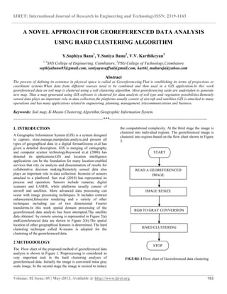
  • 1. IJRET: International Journal of Research in Engineering and TechnologyISSN: 2319-1163 __________________________________________________________________________________________ Volume: 02 Issue: 05 | May-2013, Available @ http://www.ijret.org 783 A NOVEL APPROACH FOR GEOREFERENCED DATA ANALYSIS USING HARD CLUSTERING ALGORITHM Y.Sophiya Banu1 , Y.Soniya Banu2 , V.V. Karthikeyan3 1, 3 SNS College of Engineering, Coimbatore.,2 PSG College of Technology,Coimbatore sophiyabanu05@gmail.com, soniyayusuffsai@gmail.com, karthi_maharaja@yahoo.com Abstract The process of defining its existence in physical space is called as Georeferenceing.That is establishing its terms of projections or coordinate systems.When data from different sources need to be combined and then used in a GIS application.In this work georeferenced data on soil map is clustered using a soft clustering algorithm. Most georeferencing tasks are undertaken to generate new map. Thus a map generated using GIS software is clustered for data analysis of soil type and vegetation possibilities.Remotely sensed data plays an important role in data collection,the platforms usually consist of aircraft and satellites.GIS is attached to many operations and has many applications related to engineering, planning, management, telecommunications and business. Keywords: Soil map, K-Means Clustering Algorithm,Geographic Information System. ------------------------------------------------------------------***------------------------------------------------------------------------ 1. INTRODUCTION A Geographic Information System (GIS) is a system designed to capture, store,manage,manipulate,analyze,and present all types of geographical data in a digital formatGreene et.al has given a detailed description. GIS is merging of cartography and computer science technologyHeywood et.al (2006) has denoted its applications.GIS and location intelligence applications can be the foundation for many location-enabled services that rely on analysis and dissemination of results for collaborative decision making.Remotely sensed data also plays an important role in data collection. Itconsist of sensors attached to a platformJ. Sun et.al (2010) has represented its process and operation. Sensors include cameras, digital scanners and LASER, while platforms usually consist of aircraft and satellites. More advanced data processing can occur with image processing techniques. It includes contrast enhancement,falsecolor rendering and a variety of other techniques including use of two dimensional Fourier transforms.In this work spatial domain processing of the georeferenced data analysis has been attempted.The satellite data obtained by remote sensing is represented in Figure 2(a) andGeoreferenced data are shown in Figure 2(b).The spatial location of other geographical features is determined. The hard clustering technique called K-means is adopted for the clustering of the georeferenced data. 2 METHODOLOGY The Flow chart of the proposed method of georeferenced data analysis is shown in Figure 1. Preprocessing is considered as very important task in the hard clustering analysis of georeferenced data. Initially the image is converted intoa gray scale image. In the second stage the image is resized to reduce the computational complexity. At the third stage the image is clustered into individual regions. The georeferenced image is clustered into regions based on the flow chart shown in Figure 3. FIGURE 1 Flow chart of Georeferenced data clustering READ A GEOREFERENCED IMAGE IMAGE RESIZE HARD CLUSTERING START RGB TO GRAY CONVERSION STOP
  • 2. IJRET: International Journal of Research in Engineering and TechnologyISSN: 2319-1163 __________________________________________________________________________________________ Volume: 02 Issue: 05 | May-2013, Available @ http://www.ijret.org 784 (a) (b) FIGURE 2 (a) Satellite image (b) Georeferenced data 2.1 GeoreferncedData Cartography isa branch of science that deals with the design and production of maps Calvertet.al (2013) has mentioned its importance.It is the visual representation of spatial data. The vast majority of modern cartography is done with the help of computersPerry et.al (2006) has denoted a detailed procedure of georeferencing. GIS based maps are best in quality but production of quality cartography is also achieved by importing layers.A design program to refine it is appliedFonseca andEgenhofer (1999) has given a brief introduction to soil maps. Most GIS software gives the user friendly control over the appearance of the data.A map produced using a GIS software is considered as the input to the soft clustering analysis of georeferenced data analysis process. A soil map is a visual representation of an area. Soil map is a map that is a geographical representationSarma and Jean-Paul Legros (2005) has denoted its developments. It shows the diversity of soil types and soil properties in the area of interest. It is typically the end result of a soil survey investigations Chang, K. T (1989) has denoted its importance. Soil maps are most commonly used for land evaluation.Spatial planning, agricultural extension, environmental protection and similar process can also be applications of soil map. In this work the soil map is read as an input through the Matlab command. Many maps are static two-dimensional, geometrically accurate representation of three dimensional spacesClarke K. C (1986) has given its process and applications. Soil maps are typically richer in context and show higher spatial details than the traditional soil maps. 2.2 Image Resize Image resize is the second task of the process flow as depicted by the Figure 1. The imresize command in matlab without altering the pixel values it resizes the image and also computes the number of rows or columns automatically to preserve the image aspect ratioBentoutou et.al (2002) has given detailed procedure. Hence the georeferenced Image is resized to (256 x 256). 2.3 RGB to Gray Conversion There are several established color models used in computer graphics, but the two most common are the RGB model (Red- Green-Blue) for computer display and the CMYK model (Cyan-Magenta-Yellow-Black) for printing Gonzalez and Woods (2008) has presented a detailed view about digital image processing. When red, green and blue light is combined it forms white. Thus to reduce the computational complexity the georeferenced data that exists in RGB color model is converted intoa gray scale image.The range of gray scale image from black to white values can be calculated by equation (1). Where L is Luminance, R is RED, G is Green and B is Blue. L = 0. 2989 ∗ R + 0.5870 ∗ G + 0.1140 ∗ B (1) 2.4 Hard Clustering Simulation Results K-Means Clustering algorithm is also called as Hard clustering technique. Clustering based image segmentation is a pixel by pixel segmentation method, and it stops the process of clustering when the image is segmented into predefined number of clusters. The flow chart of hard clustering technique is denoted in the Figure 3. A cluster is therefore a collection of objects which are “similar” between them and are “dissimilar” to the objects belonging to other clusters J. Wood (1996) has denoted its results. The segmentation results of georeferenced data are shown in Figure 3. The input image is preprocessed and clustered into individual regions Tianand Guo (2011) has presented the advantages of clustering the soil maps and georeferenced data. In this work georeferenced soil map is taken as input is represented in Figure 2(b). The Hard clustering technique is initiated with cluster value 5. In this work Image segmentation is carried using K-Means Clustering algorithm. K-Means is a method of clustering which allows one piece of data to belong to two or more clusters. It is based on minimization of the distance between the clusters. Partitioning is carried out through an iterative optimization of the mean distance between the cluster centers. Segmentation is the process of partitioning a digital image into multiple segments Choi et al (2011) has denoted the segmentation process. The goal of segmentation is to simplify and change the representation of an image into something that is more meaningful and easier to analyze. In this project clustering technique is used for image segmentation of chromosomal images. The segmentation results are represented in Figure 4. The region by region segmented
  • 3. IJRET: International Journal of Research in Engineering and TechnologyISSN: 2319-1163 __________________________________________________________________________________________ Volume: 02 Issue: 05 | May-2013, Available @ http://www.ijret.org 785 image are denoted in Figure 4((a),(b),(c),(d)). Figure 4((e)and(f)) are the segmented results of FCM. The segmented image is coded with specific color for understanding using Matlab commands. FIGURE 3 Flow chart of hard clustering ALGORITHM STEP 1: Initialize the K with 5 (K=1,……………….N). STEP 2: Initialize cluster center 𝒄 𝒏(n=1…..K) STEP 3: Data grouping based on defined K values. STEP4: Reshaping the clustered data and display the segmented image. STEP 5: Determine the presence and absence of data remaining. STEP 6: Increment the K value for further segmentation if the remaining dataexist. If else stop the process (a) (a) (b) (c) (d) (e) (f) Figure 4Simulation results (a) Gray scale image, ((b),(c),(d),(e),(f))Regions segmented START INITIALIZATION START WITH K CENTERS DISPLAY AS IMAGE IF DATA LOSS NO STOP YES INCREASE K value
  • 4. IJRET: International Journal of Research in Engineering and TechnologyISSN: 2319-1163 __________________________________________________________________________________________ Volume: 02 Issue: 05 | May-2013, Available @ http://www.ijret.org 786 3. CONCLUSION AND FUTURE WORK Georeferenced data analysis is one of the important tasks in the field of Geospatial Information Studies. It denotes the academic discipline or career of working with geographical information. During the analyzing process complex image retrieved from the satellite is georeferenced using GIS software. In the similar manner the soil map thus received using a resource satellite is the input to this proposed method of Hard clustering technique. A Hard clustering technique which is the other name of the K- Means Clustering algorithm has been attempted with a soil map image. The segmented results produced by K- Means are denoted in Figure 4. When the complexity of the image increases the efficiency in computing decreases. The proposed method of georeferenced data analysis uses a preprocessing stage before clustering. Thus it reduces the segmentation error. Georeferenced data which are read as an input has been segmented into region by region. The pixel by pixel clustering for georeferenced data analysis is an ideal method even in the case of a noisy image because the input image can be denoised using any of the spatial domain or frequency domain filters. It would be less complex to analyze the possibility of vegetation and the types of soil with the help of a soft clustering technique by a Geoinformatics scholar when compared with the hard clustering results represented in Figure 4((c) and (d)). The K- Means clustering algorithm techniques has been evolving with its adaptive nature. Hence if such Adaptive nature of K- Means clustering algorithm is used it would produce even better quality of segmented result. A comparative study is possible with the emerging algorithms of clustering. Thus when compared with the soft clustering segmented result shown in Figure 4((e) and (f)) the K- Means segmented results are needed to be improved for further analysis. Hence for georeferenced data analysis process using clustering technique the soft clustering technique based on Fuzzy clustering is advantageous than the hard clustering technique. REFERENCES [1] Greene, R., Devillers, R. and Luther, J. "GIS-based multi-criteria analysis". Geography Compass 5/6, 412–432. [2] Heywood, I., Cornelius, S., & Carver, S. “ An Introduction to Geographical Information Systems”, Third Edition. Essex, England: Prentice Hall, 2006. [3] K. Calvert, J. M. Pearce, W.E. Mabee, “Toward renewable energy geo-information infrastructures: Applications of GIScience and remote sensing that can build institutional capacity” Renewable and Sustainable Energy Reviews 18, pp. 416–429, 2013. [4] Chang, K. T. "A comparison of techniques for calculating gradient and aspect from a gridded digital elevation model".International Journal of Geographical Information Science 3 (4): 323–334, 1989. [5] Chang, K. T. “Introduction to Geographical Information Systems”. New York: McGraw Hill. pp. 184, 2008. [6] Fu, P., and J. Sun,” Web GIS: Principles and Applications” ESRI Press. Redlands, CA, 2010. [7] Clarke, K. C., “ Advances in geographic information systems, computers, environment and urban systems”, Vol. 10, pp. 175–184,1986. [8] Sarma and Jean-Paul Legros, “Mapping of the soil cover”, Enfield, NH, USA, Science Publishers,2005. [9] Cao H. and Wang Y. “Segmentation of M-FISH images for improved classification of chromosomes with an adaptive Fuzzy C-Means Clustering Algorithm”. IEEE Transaction on Biomedical Imaging ,20(1), 1442–1445,2011. [10] Rafel C. Gonzalez , and Richard E. Woods.”Digital Image Processing”. Pearson Education Third ed.2008. [11] Perry, Matthew, Hakimpour, Farshad, Sheth and Amit,” Analyzing Theme, Space and Time”, proc. ACM International Symposium on GIS.pp.147- 154,2006. [12] Fonseca Frederico, and Egenhofer, "Ontology- Driven Geographic Information Systems". Proc. ACM International Symposium on Geographic Information Systems. pp. 14–19,1999. [13] Ma, Y., Guo, Y.,andTian, X., "Distributed Clustering-Based Aggregation Algorithm for Spatial Correlated Sensor Networks".IEEE Sensors Journal 11 ,2011. [14] J. Wood, “Invariant pattern recognition: A review,”PatternRecognit., vol. 29, no. 1, pp. 1–17, Jan. 1996. [15] Y. Bentoutou, N. Taleb, M. C. E. Mezouar, M. Taleb, and L. Jetto, “An invariant approach for image registration in digital subtraction angiography,”PatternRecognit., vol. 35, no. 12, pp. 2853–2865, 2002. [16] B. Mahdian and S. Saic, “Detection of copy-move forgery using a method based on blur moment invariants,”Forensic Sci. Int., vol. 171, no. 2/3, pp. 180–189, Sep. 2007. [17] V. Ojansivu and J. Heikkilä, “A method for blur and similarity transform invariant object recognition,”inProc. ICIAP, R. Cucchiara, Ed., 2007, pp. 583–588.