L'impact des métaux lourds sur la santé et le bien-être et comment les éliminerHyacinthe Toure
Nous ingérons chaque jour des métaux lourds par l’air que nous respirons, l’eau que nous buvons, la nourriture que nous mangeons, les cosmétiques que nous utilisons et notre mode de vie (cigarettes, boite de nuit, etc.). Ces métaux lourds sont à la base de nombreuses maladies, mais difficile à déloger. Découvrez un supplément naturel qui est capable de les éliminer de votre organisme.
effet de l'incorporation d'ajuvant minéraux sur les propriétés des ciments g...Noël Djobo
Volcanic ashes are raw materials with variable chemical and mineralogical compositions from one deposit to another. When combined with suitable alkali activators they can be converted to geopolymer cements at ambient temperature. In this study we investigate the possibility of use bauxite and calcined oyster shell powders as mineral additives to volcanic ashes in other to enhance the properties of the resulted geopolymers. Different methods of analyses such as Fourier Transform Infrared Spectroscopy, X- Ray Diffractometry and Scanning Electron Microscopy were used to assess the variations of setting time, linear shrinkage and 28 days compressive strength of geopolymer pastes. Also, chemical and mineralogical compositions of bauxite and calcined oyster shell were determined. It appeared that bauxite and calcined oyster shell are respectively sources of Al2O3 and CaO and can compensate the deficiency of these oxides in volcanic ashes. These mineral additives are weakly dissolved in alkaline medium due to their high crystalline phase content. Addition of about 20 % of bauxite or 10 % calcined oyster shell lead to the decreasing of the setting time respectively from 415 to 275 min (bauxite) and 195 min (calcined oyster shell). Addition of any percentage of these minerals lead to the decrease of linear shrinkage and 10 % of bauxite is enough to prevent efflorescence. The increasing of the 28 days compressive strength of the geopolymers synthesized is trivial up to 10 to 20% addition of bauxite and calcined oyster shell respectively. More than these percentages additives have deleterious effect on the compressive strength.
Travail bibliographique sur l'AG dans les sulfoselsIbrahim Hajdari
Le groupe de sulfures et de sulfosels et composé d’éléments métalliques ou de métalloïdes en association avec le soufre et a, économiquement parlant, une grande importance car de nombreux gisements métalliques lui appartiennent.
La plupart d’entre eux peuvent être très facilement identifiés grâce à leur éclat métallique. Alors que les minéraux natifs sont très fragiles, les sulfures ne le sont pas. Quelques-uns d’entre eux résistent bien aux agents atmosphériques ; ils peuvent aussi donner des minéraux secondaires. Dans les gisements, on ne les rencontre que dans les zones les plus profondes.
On les divise en composés simples qui résultent de l’association d’un élément métallique avec le soufre : ce sont les sulfures, et en composés plus complexes résultant de l’association d’un élément métallique avec le soufre et contenant en outre un métalloïde (As, Sb ou Bi) : ce sont des sulfosels.
Developing inclusive visions for transforming value chains Catherine Pfeifer
Developing inclusive vision for transforming livestock value chains using participatory modelling and serious gaming in Sub-Saharan Africa, presentation OSM 2019 in Bern.
CLEANED tool : Live spatial simulation to develop a shared vision for a susta...Catherine Pfeifer
This slides were presented at FOSS4G meeting in Dar Es Salaam. It shows how open source technology and open source data can be used as a neutral entity in the multi-stakeholder negotiation to solve complex societal problem.
- CLEANED-R is a landscape scale and spatially explicit tool for integrating open geographical data to assess the environmental impacts of land use changes. It has 5 core modules (production, greenhouse gases, water, soil, biodiversity) and a land use change module.
- The tool is being used and tested within the ResLess project to facilitate social learning around sustainable land use scenarios. It provides environmental scorecards to compare scenarios and identify tradeoffs.
- Preliminary results from applying the tool in Burkina Faso show that a negotiated scenario between agro-pastoralists and mixed farmers increased some socioeconomic indicators while reducing environmental impacts compared to the initial scenarios. The tool helped facilitate agreement by providing a neutral
Presentation given at the Animal Health Delivery workshop co-hosted by ILRI and Technoserve. This presentation shows on going work and discusses the potential of drones.
This document discusses using Demographic and Health Survey (DHS) data to conduct livestock research in several areas:
1) Agricultural population mapping and poor livestock keeper mapping can be done by extracting cluster-level livestock ownership and wealth index data.
2) Gender context maps for value chains can be created by combining DHS women's survey data with other sources to map factors like education and asset ownership.
3) Understanding the linkage between livestock ownership, poverty, and consumption of animal-sourced foods can provide insights for the poor by analyzing wealth index, livestock ownership, and nutrition data.
4) Potential future research includes creating absolute poverty maps, further investigating the linkage between livestock ownership and nutrition, and assessing relationships between
This one-day training introduces participants to GPS and GIS. It will teach them how a GPS works, different GIS software options, and how to collect and map their own spatial data. The program includes an introduction to GIS concepts, setting up a GPS, collecting points, lines and areas with the GPS, downloading the data, and mapping it in ArcGIS, QGIS or Google Earth. Participants will then discuss their work and the differences between software. The goal is for participants to understand GPS and be able to set one up, collect their own spatial data, and map it in a GIS program suited to their needs.
This one-day training introduces participants to GPS and GIS software. The objectives are to learn how GPS works, understand different GIS software options, and be able to collect spatial data using a GPS. The program includes an introduction to GIS concepts, setting up a GPS, collecting point, line and area data, downloading the data, and mapping it in software like ArcGIS, QGIS or Google Earth. Participants will discuss the software options and differences.
La valorisation des eaux usées: Pratiques et représentations relatives à l'eau, à l'eau usée et aux combustibles de cuisine dans le village sahélien de Ndem
hrpfeifer.blogspot.ch/p/conferences.html
The document discusses water management challenges in the Ethiopian Blue Nile Basin and presents approaches to address them. It outlines that while rainwater management is a known solution, interventions are not reaching communities due to issues like lack of targeting and scaling. The Nile Basin Challenge Program aims to create tools like a GIS-based suitability mapping tool and game to better target and scale rainwater management practices through research partnerships with local institutions. The goal is to improve resilience through landscape-scale integrated water management and make Ethiopia's water resources sufficient to potentially feed other parts of Africa.
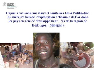
1. Impacts environnementaux et sanitaires liés à l’utilisation
du mercure lors de l’exploitation artisanale de l’or dans
les pays en voie de développement : cas de la région de
Kédougou ( Sénégal )
4. 2. Objectifs
Contamination
Quel est le niveau de contamination des différents
compartiments de l’écosystème aquatique de la région?
Les sols : sont-ils un stock ou une source de Hg (et de
méthylmercure, MeHg)?
Accumulation
Quel est le niveau d imprégnation de l ichtyofaune et
des habitants locaux en général toutes professions
confondues?
5. 2. Objectifs
Méthylation
Quels sont les processus qui contrôlent la méthylation
biotique comme abiotique notamment au sud du
Sahara?
Risques sanitaires
A court terme, quel est le risque de contamination pour
les populations se nourrissant essentiellement des
produits de la pêche du fleuve Gambie?
11. 4.2 Analyses
Dosage des métaux : ICP-MS
Microbiologie : Identification, quantification et caractérisation des
bactéries, Pcr real time
Dosage du mercure total, réactif et gazeux dissous, méthylmercure
! Spectrométrie de fluorescence atomique à vapeur froide (CV-AFS)
(Bloom et Crecelius.,1983; Mason et al., 1999;Cossa et al.,2002;2003)
! Spectrométrie d’absorption atomique (AAS, AMA-254)
! Couplage chromatographie en phase gazeuse et spectrométrie de
fluorescence atomique CG-SFA
Détermination des phases porteuses par extraction sélective
13. 5.2 Mercure dans les sédiments
Bravo et al, 2009
RomanieKédougou (Sénégal)
14. 5.3 Comparaison des teneurs en métaux avec le SQGS-PEC de
MacDonald et al. 2000
15. 5.4 Facteur d’enrichissement géologique du mercure en fonction des
sites d’échantillonnage
Sutherland,,2000,;,
Acevedos,et,al.,,2006,
EF#=#100*#[([Y]sed/[X]sed)#*([X]Ref/[Y]Ref)#4#1)#]#
,
!
16. 5.5 Teneur en mercure dans les muscles de divers espèces de
poisson
n Poids (g) THg (mg/Kg_dw)
Hepsetus odoe 1 50 1.603
Schilbe intermedius 2 450 1.229
Sarotherodon melanotheron 2 175 0.498
Alestes dentex 1 200 0.482
Orechromis niloticus 1 750 0.144
Norme : OMS/FAO 0.5
17. 5.6 Teneur en mercure au niveau des cheveux en fonction
des différents sites
18. 5.6 Teneur en mercure au niveau des cheveux en fonction
de la consommation de poisson par semaine
consommation de poisson par semaine
19. 6 Conclusions
! Les sédiments des sites d’orpaillage présentent des teneurs en THg
supérieures au PEC et sont susceptibles de causer des effets
probables pour l’ichtyofaune.
! Le facteur d’enrichissement montre que les sédiments au niveau
des sites d’orpaillage connaissent une contamination sévère tandis
que celui de Sabodala est extrêmement sévère.
! Certains poissons au niveau du fleuve présentent des taux de THg
supérieurs aux normes OMS/FAO.
! Il faut penser à des changements dans les techniques d’orpaillage
avec l’introduction de rotors.
20. MERCI
Prof. Robert Moritz
Prof. Hans-Ruedi Pfeifer (Unil), Dr. Stéphane Guédron (U.J.F),
Prof. Papa Malick Ngom (Ucad), Dr. John Poté (Unige)