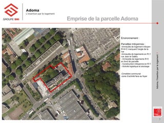
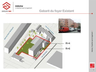
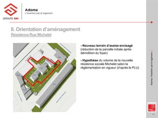
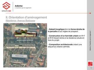
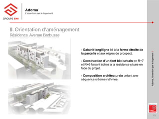
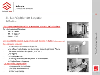
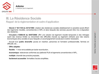
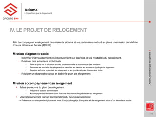
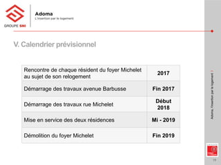
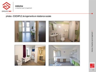
Réunion publique du 12 avril 2017 portant sur la présentation du projet d’évolution du Foyer Michelet, géré par le bailleur Adoma. Ce projet prévoit la transformation du foyer actuel en résidences sociales situées au 4B-6 avenue Henri Barbusse et au 4-14 rue Michelet avec une reconstitution de l’offre existante (256 logements)
Clarence Perry was an American urban planner from the early 20th century. He is considered a pioneer in neighborhood unit planning. The key aspects of Perry's neighborhood unit model include centering an elementary school in the middle, placing arterial streets along the perimeter, designing a hierarchy of internal streets, and restricting local shopping to the perimeter. The goal was to create self-contained neighborhoods that promoted community and protected residents, especially children, from traffic.
The document discusses the key elements of urban design including buildings, building blocks, and streets. It explains that urban design involves coordinating these elements to create a coherent physical structure for cities. Buildings are designed at different scales from individual structures to neighborhoods. Building blocks are groups of buildings surrounded by streets that give areas a distinctive character. Street design must balance traffic flow with creating attractive pedestrian spaces incorporating streetscape elements. The example of Calle Crisologo in Vigan, Philippines highlights how coordinating these elements can preserve historical beauty.
An Urban Design Approach to a Sustainable Compact City in New Growth Potentia...drboon
Existence of Cities always depends on the region for the resources-land, food, water, energy or maybe cheap labor. The resource base is vital for the survival of the cities. With increasing urban sprawl there is a great impact on the future of cities and their sustenance. The primary intent of the study is to demonstrate an Urban Design approach towards a sustainable compact urban model in new growth potential areas (case of Cyberabad, Hyderabad, India) as a means to counteract city’s faceless sprawl and environmental degradation by generating compact high density, low energy, mixed-use living and integrating it with the existing city fabric reducing the ecological footprint for future generations. As the selected site offers good natural features, ecologically sensitive areas of the site i.e. Steep slope areas, catchment channels and climatically unsuitable areas from the open space system of the development. The sustainable compact city design approach balances the environmental loads and the growth of city saving resources, conserving energy and enhancing the quality of life.
Presentation on townplanning of irfhaa fathe (1)Shiek Fathe
The document discusses four main concepts in town planning and development introduced in the early 19th century:
1) The Garden City Concept focused on overcoming problems of congestion and increasing population through satellite towns around a central city.
2) The Neighborhood Unit concept aimed to improve social conditions and the physical layout of towns through neighborhood design.
3) The Parallel Town Concept emphasized developing towns along main transportation corridors with housing and green spaces on either side.
4) Urban Land Use Models proposed concentric zoning of land uses including central business districts, industrial zones, and residential zones for different income levels.
National greening program inspection reportRdc Cordillera
This report contains the status, basic information and findings and recommendations on the recently concluded project inspection of the National Greening Program
The document discusses types of urban design as presented by Nguyen Dang Phuong Linh at Hanoi Architectural University in 2014. It focuses on Le Corbusier's master plan for Chandigarh, India, which was conceived as a "Garden City" with 30% of land allocated to parks. The plan included overall urban design with sectors and superblocks, all-of-a-piece design to capture unity and variety, infrastructure like roads designed for pedestrians and cyclists, and urban guidelines to accommodate future growth in a human-scaled way.
The document discusses planned unit developments (PUDs). It provides background on the evolution of PUDs in the 1960s-1970s as a way to comprehensively plan large parcels of land rather than individual lots. PUDs aim to mix uses and create more interesting developments than traditional zoning allows. The document defines PUDs and outlines their objectives, classification, design principles, steps for development, and advantages and disadvantages compared to traditional zoning. Case studies are also mentioned.
Proposed Garden City Zoning in Kawit, CaviteShayne Galo
The document proposes an urban planning concept called "Revitalization" for Kawit, Cavite. It involves three main strategies: Revitalize, Revive, and Relight. Revitalize reconfigures streets with center parking and landscaping. Revive makes sidewalk extensions for pedestrian safety. Relight installs new energy-efficient street lighting. It also discusses the Garden City Movement, which promotes planned, self-sufficient towns surrounded by greenbelts that integrate residences, industry and agriculture. Applying this model to Kawit could provide social and economic benefits through compact, walkable and mixed-use development.
A Case study in context of heritage in Bhaktapur and Patan, Kathmandu valleyAmit Pokharel
The existing legislative measures in Nepal are insufficient to preserve vernacular architecture in the Bhaktapur and Patan monument zones, which are part of the UNESCO World Heritage Site of the Kathmandu Valley. Key issues include a lack of identification and protection of privately owned traditional residential buildings, as well as overlapping responsibilities between governing authorities. Recommendations include revising laws to provide incentives for owners to maintain historic structures, improving coordination between organizations, and developing sustainable funding strategies focused on community participation to help conserve architectural heritage in these areas.
Jane Jacobs was an influential writer and activist in urban planning in the mid-20th century. She opposed the widespread replacement of urban communities with high-rise buildings and advocated for mixed-use neighborhoods with a focus on walkability. Along with Lewis Mumford, she is considered a founder of the New Urbanist movement. New Urbanism aims to reduce car dependence and create livable, walkable neighborhoods with a mix of housing, jobs, and commercial areas. Some examples of New Urbanist developments include Seaside, Florida, the first fully New Urbanist town, and Stapleton in Denver, Colorado. However, New Urbanism has also faced some criticisms around issues like lack of privacy and questions about how well it achieves
Human Settlements Planning In The Philippines.pptxCarmela857185
The document summarizes several key Philippine government offices and laws related to housing and human settlements. It outlines the government agencies that oversee housing development and finance, including the Department of Human Settlements and Urban Development, Home Development Mutual Fund, Human Settlements Adjudication Commission, National Housing Authority, and National Home Mortgage Finance Corporation. It also briefly describes several laws such as the Urban Development and Housing Act of 1992, Subdivision and Condominium Buyer's Protective Decree, and Realty Installment Buyer Protection Act that regulate land use planning, subdivision/condo development and sales, and protect buyers/owners.
The Miami Beach Soundscape project redesigned a 2.5 acre site adjacent to Frank Gehry's New World Symphony building to create an open green space for the community. West 8 designed undulating topography, meandering pathways, seating walls, and pergolas providing shade. The design was intended to attract younger generations to classical music through outdoor movies and concerts. Since opening, the space has seen great success in attracting the local community and transforming the area into a cultural destination through the day and night.
The document discusses India's Pradhan Mantri Awas Yojana (PMAY) housing program. It was launched in 2015 to achieve the goal of "Housing for All" by 2022. The program aims to build 20 million affordable housing units across urban and rural areas. It has four components: slum rehabilitation with private developers; affordable housing through credit-linked subsidies; affordable housing through public-private partnerships; and subsidies for individual home construction. Implementation has faced challenges with only 82,048 units constructed as of 2017. Stakeholders are working with the PMO to address issues like land and clearances to accelerate progress and achieve the program targets.
The document discusses four key concepts in town planning development:
1) The Garden City Concept from 1902 aims to address overpopulation and congestion through self-sufficient, planned communities of around 32,000 people surrounded by greenbelts.
2) The Neighborhood Unit from the 1920s arranges residential areas around a central hub to improve social conditions and infrastructure, with schools and shops at the center serving around 5,000 people.
3) Parallel Towns from the 1930s focus development along major transportation corridors with housing, industry, and green spaces arranged on either side.
4) Urban Land Use Models from the 19th century propose concentric zoning of land uses from the city center outward, separating residential,
Urban Design at different levels of PlanningYajush Sonar
This document provides guidelines for urban design in several areas:
1. It discusses the basics of urban design including its multi-disciplinary nature and focus on designing places for people.
2. Guidelines are given for massing and intensity in urban fringe and rural areas, including respecting the natural environment and providing linkages between urban and rural spaces.
3. Recommendations are made for development height profiles including stepping down heights from city centers to edges and maintaining view corridors.
The document discusses various international charters, conventions and legislations related to urban conservation and heritage protection. It outlines strategies like urban renewal, redevelopment and regeneration which aim to address issues like urban decay, obsolescence and blight. Sustainable approaches to urban conservation involve balancing development needs with preserving built heritage through master planning and policies controlling land use, density and traffic management while prioritizing pedestrianization. Brownfield and greenfield development options are also compared.
Brgy. Labangon, Cebu City and the Threat to its Territorial IntegrityHarve Abella
the people have spoken, NO to the creation of Banawa-Englis.
by the way, Tony Cuenco (author of the Banawa-Englis law fiasco) has bowed out of the congressional race (or so he claims.) do we really need recycled politicians???
Bonifacio Global City is a 240-hectare business district in Taguig City that was developed from a former military base. It has a master plan that includes mixed-use developments, pedestrian-friendly design, ample open spaces and landscaping, and access to public transit. The grid system and centralized parking help make the area easily navigable and traffic-free.
1996 presentation by Nick Wates on community architecture explaining what it is, how it works, why it works and what has been achieved so far. Shown in Pittsburgh, Poland, Tokyo and Richmond, Virginia.
The document discusses building great neighbourhoods in Red Deer through careful planning and design. It outlines nine principles for creating neighbourhoods that are sustainable, walkable, vibrant, and livable. These include considering natural areas, a mix of land uses, connectivity through various transportation options, compact urban form and density, parks and community spaces, housing variety, resilience and sustainability, safety, and unique identity. The standards provide guidance for both new neighbourhood developments and smaller redevelopment within existing areas to achieve well-designed neighbourhoods that improve quality of life.
This document discusses urban design and its definition. It defines urban design as the design of towns and cities, addressing both aesthetic and functional issues. Urban design involves the design of public spaces like streets, sidewalks, and plazas between buildings. It also discusses definitions of urban areas in the Philippines, including population density and presence of basic services criteria used to define urban barangays.
PD 1067 Philippine Water Code of the Philippines- DAO 2021-07 Easement.pptxCymagneDonnaAquino2
This document provides guidelines for establishing legal easements along seas, rivers, lakes, esteros and creeks in the Philippines according to existing laws and regulations. It defines key terms and sets the following standards for easement zones: 3 meters for urban areas, 20 meters for agricultural areas, and 40 meters for forest areas, national parks, and reclaimed areas. The easements are measured from mean high water lines, shorelines, or normal high water marks. Regional DENR offices will monitor compliance and enforce relocation or demolition of non-compliant structures.
The document discusses the emergence and development of urban communities and metropolitan areas. It defines key terms like urban area, urbanization, metropolis, exurban, and suburban. It then describes the history of early cities appearing thousands of years ago along fertile river valleys. It also outlines the origin of urbanization in places like Mesopotamia, India, China, and how most rapid urbanization occurred in America, Europe in the 20th century. The document also discusses the classification of cities in the Philippines and identifies 12 metropolitan areas as the country's leading industrial and economic centers.
A green building aims to minimize its environmental impact over its lifecycle. It conserves energy and resources during construction and operation through various design strategies. These include efficient site planning, building materials selection, renewable energy integration, water and waste management practices, and indoor environmental quality maintenance. Green buildings provide environmental benefits like reduced pollution and energy usage while creating healthier spaces for occupants.
This document provides a brief history of urban planning from the late 19th century to today. It describes how planning emerged in response to health and social crises in cities during the Industrial Revolution. Early influences included Marxism, the Romantic and Progressive movements, and public health reformers seeking to address overcrowding, pollution and disease through parks, infrastructure and zoning. Notable figures who shaped early planning ideas and projects included Frederick Law Olmsted, Ebenezer Howard, Le Corbusier and Frank Lloyd Wright, though their utopian visions did not always match reality. Zoning and master plans became common planning tools in the 20th century, though zoning often exacerbated social inequities and sprawl remains a challenge
Restructuration de l‘ ancien hôpital Jean Rostand implantation d'une résidence intergénérationnelle et de locaux d’activités. construction d'un ensemble résidentiel neuf "Villa d'Ivry" réunion publique du 10 mai 2016
The document contains architectural plans for a residential building project called "Le Julia" located in Ivry-sur-Seine, France. The plans include site plans, floor plans, elevations, sections, and renderings. They show the layout of horizontal and vertical circulations, common areas, residential units, and vehicle areas across multiple levels of the building. Sunlight studies are also presented to analyze sunlight exposure at different times of day and seasons.
la Maison Africaine est agréée pour l’accueil et l’hébergement d’étudiants étrangers. L’équipe de la Maison Africaine met tout en œuvre pour apporter une qualité d’accueil.
Dans le cadre de la politique générale menée par le gouvernement de Sa Majesté Le Roi visant l’encouragement des investissements nationaux et étrangers dans divers secteurs de diverses d’activités socio-économiques, et dans le cadre de développement socio-économique que connaît actuellement la wilaya de chaouia ouardigha et plus particulièrement l’intensification des projet d’investissement dans la province de Berrechid nouvellement créée et en particulier dans le territoire de la commune de deroua.
C’est dans ce contexte que le promoteur investisseur : la société « Isi Group Italia » envisage de réaliser le projet de construction d’un ensemble d’immeubles socio-collectifs d’habitations et de commerces « EL WAHA », qui contribuera au développement de cette commune et participera et à l’absorption de manque des logements sociaux dans cette région.
Dossier : la Concertation ZAC Part-Dieu Ouest (Lyon, janvier 2015)xavierPN
Depuis le 5 janvier, les habitants sont appelés à participer à la concertation organisée par la mission Part-Dieu au sujet de la Zone d'Aménagement Concerté Part-Dieu Ouest, qui couvre un territoire de 38 ha.
De part son emplacement (boulevard Deruelle au Nord, boulevard Vivier-Merle à l'Est, la rue Paul Bert au Sud et la rue Garibaldi à l'Ouest), la ZAC Part-Dieu Ouest), le Conseil de Quartier doit s'impliquer et participer activement à cette concertation pour le moins discrète !
Similaire à Projet d'évolution du foyer Michelet - Ivry-sur-Seine (20)
2. 2
Adoma,l’insertionparlelogementI
Présence d’Adoma
sur le territoire
Français
Adoma, société anonyme d’économie mixte créée en 1956
Nombre total général de logements : 71 616
Dont en IDF : 30 000 logements
Nombre de salariés : 2 400
Dont en IDF : 760
4. 4
Adoma,l’insertionparlelogementI
Sommaire
I. Etat des lieux du foyer actuel et contexte
II. Présentation des orientations d’aménagement
III. Définition d’une résidence sociale
IV. Politique de relogement : l’accompagnement des
résidents
V. Calendrier prévisionnel
VI. Exemples de réalisation
5. 5
Adoma,l’insertionparlelogementI
I. Etat des lieux du foyer actuel
Le Foyer est implanté 4 – 14 rue Michelet, proche des services et des commerces,
à 400 mètres de la station de métro « Mairie d’Ivry » (ligne 7).
Situé en Quartier Prioritaire de la Ville.
Edifié en 1972 et il a été en service en 1974
Il est actuellement composé de :
• 256 chambres de 7,5 m² organisées en unité de vie
• de 7 logements autonomes (studios)
• d’un parking de 38 places.
Et des locaux suivants :
• D’un bureau pour le responsable de résidence,
• D’un local pour le personnel,
• D’un atelier pour l’ouvrier de maintenance
• D’une lingerie.
Le foyer se compose de 2 corps de bâtiments en R+6 et R+4 et d’un niveau semi-enterré
7. 7
Adoma,l’insertionparlelogementI
Environnement :
Parcelles mitoyennes :
-Immeuble de logement mitoyen
R+4+C marquant l’angle de la
rue
-Immeuble de logements en R+1
rue Jean le Galleu
- Immeuble de logements R+5
en fond de parcelle
- Construction mitoyenne en R+1
- Activité logistique et stockage
-Cimetière communal
-zone d’activité face au foyer
Emprise de la parcelleAdoma
9. 9
Adoma,l’insertionparlelogementI
Le foyer de travailleur migrant tel que présenté aujourd’hui ne répond plus à la demande
actuelle.
La quasi-totalité des logements n’étant pas autonome et le foyer présentant un état général
dégradé un traitement devient nécessaire pour une transformation du foyer en résidence sociale
- en accord avec les partenaires d’Adoma (notamment avec la ville et l’Etat).
La réhabilitation du foyer ne peut être envisagée en raison de l’occupation du bâtiment par ses
résidents et des contraintes techniques qu’elle imposerait.
Cette transformation se traduit donc par la démolition du foyer, dont la capacité sera
reconstituée au préalable par des constructions neuves sur deux sites distincts :
- En parti en fond de parcelle au 4-14 rue Michelet
- En parti au 4bis/6 avenue Henri Barbusse
►►► Ce projet est une reconstitution à l’identique de l’offre existante en terme de capacité
d’accueil
I. Contexte et Etat des lieux
10. 10
Adoma,l’insertionparlelogementI
II. Orientation d’aménagement
4-14 rue Michelet
Par la mobilisation de la constructibilité résiduelle en fond de
parcelle pour permettre la réalisation d’une résidence sociale
de 77 logements, avant démolition du foyer ;
Après relogement des résidents du foyer dans ces deux résidences sociales, d’une capacité totale de 259 logements, la démolition du
foyer sera rendue possible avant la cession de la parcelle en front de rue.
4bis/6 avenue Barbusse
Par le biais d’une Acquisition en VEFA d’une résidence
sociale de 182 logements en R+7 au promoteur Territoire et
Développement
Reconstitution de la capacité de foyer existant sur les
deux sites suivants :
12. 12
Adoma,l’insertionparlelogementI
II. Orientation d’aménagement
Résidence Avenue Barbusse
- Gabarit longiligne lié à la forme étroite de
la parcelle et aux règles de prospect.
- Construction d’un font bâti urbain en R+7
et R+6 faisant échos à la résidence située en
face du projet.
- Composition architecturale créant une
séquence urbaine rythmée.
R+5
13. 13
Adoma,l’insertionparlelogementI
II. Orientation d’aménagement
Résidence Avenue Barbusse
- Gabarit longiligne lié à la forme étroite de
la parcelle et aux règles de prospect.
- Construction d’un font bâti urbain en R+7
et R+6 faisant échos à la résidence située en
face du projet.
- Composition architecturale créant une
séquence urbaine rythmée.
16. 16
Adoma,l’insertionparlelogementI
III. La Résidence Sociale
Définition
Des logements entièrement autonomes, équipés et accessible
De trois typologies différentes :
- T1 : 16 à 18 m²
- T1’ : 20 à 22 m²
- T1 Bis : 30m²
Des logements adaptés aux personnes à mobilité réduite (5% du programme)
Des espaces collectifs
- Un hall d’entrée et un espace d’accueil
- Une salle polyvalente pour les réunions de résidents gérée par Adoma
- Une laverie automatique ouverte 7 jours sur 7
- Une lingerie
- Un local deux roues
- Un parking recevant quelques places de stationnement
- Un local ordures ménagères
Un personnel de proximité
- Un responsable de résidence
- Un ouvrier de maintenance
- Un intervenant social
17. 17
Adoma,l’insertionparlelogementI
III. La Résidence Sociale
Rappel de la règlementationet cadre d’application
Décret n° 94-1130 du 23/12/1994: création des résidences sociales (établissement à caractère social offrant
des logements meublés, conventionnés à l’APL et dans lesquels des services peuvent être mis à disposition
des résidents).
Circulaire n°2006-45 du 04/07/2006: offrir une solution de logement meublé temporaire à des ménages
ayant des revenus limités ou rencontrant des difficultés d’accès au logement ordinaire pour des raisons
économiques et/ou sociales et pour lesquels un accompagnement social peut s’avérer nécessaire.
Accueil d’un public diversifié: jeunes en insertion, personnes en formation professionnelle, femmes en
difficulté, etc…
Offre adaptée:
− flexible : 1 mois renouvelable par tacite reconduction,
− économique: redevances conformes aux plafonds PLAI et logements conventionnés à l’APL,
− multiple: diversité des produits proposés,
− facilement accessible: formalités d’accès simplifiées.
18. 18
Adoma,l’insertionparlelogementI
IV. LE PROJET DE RELOGEMENT
Afin d’accompagner le relogement des résidents, Adoma et ses partenaires mettront en place une mission de Maîtrise
d’œuvre Urbaine et Sociale (MOUS)
Mission diagnostic social
• Informer individuellement et collectivement sur le projet et les modalités du relogement.
• Réaliser des entretiens individuels
Faire le point sur la situation sociale, professionnelle et économique des résidents.
Recenser les souhaits de relogement et identifier les besoins en termes de typologie de logement.
Repérer les freins potentiels au relogement et les problématiques d’accès aux droits.
• Rédiger un diagnostic social et établir le plan de relogement
Mission accompagnement au relogement
• Mise en œuvre du plan de relogement
Préparer le dossier administratif
Accompagner les résidents dans chacune des démarches préalables au relogement
• Accompagnement dans l’appropriation du nouveau logement
→ Présence sur site pendant plusieurs mois d’un(e) chargé(e) d’enquête et de relogement et/ou d’un travailleur social
19. 19
Adoma,l’insertionparlelogementI
V. Calendrier prévisionnel
Rencontre de chaque résident du foyer Michelet
au sujet de son relogement
2017
Démarrage des travaux avenue Barbusse Fin 2017
Démarrage des travaux rue Michelet
Début
2018
Mise en service des deux résidences Mi - 2019
Démolition du foyer Michelet Fin 2019
Les résidences sociales sont issues du décret du 23 décembre 1994 : ce sont des établissements à caractère social…
La circulaire du 4 juillet 2006 précise que les résidences sociales doivent offrir une solution de logement meublé temporaire à des ménages…
Les résidences sociales doivent pouvoir accueillir un public diversifié : jeunes en insertion, personnes en formation professionnelle, femmes en difficultés. On peut ajouter les familles monoparentales, des personnes isolées. Les résidences sociales constituent une offre de logement adaptée. Ce sont des logements flexibles et temporaires (durée de séjour de 1 à 24 mois). Les redevances incluent les charges liées au logement et sont conformes aux plafonds PLAI. Les résidences sociales proposent également des typologie de logement allant du T1 au T1 bis voire au T2.
Enfin les formalités d’accès sont simplifiées via la demande en ligne par exemple.